TopoQuest Logo
Do you find TopoQuest useful?
Help keep TopoQuest running and adding new maps/features by donating!
Bitcoin:  19c7KJd3qBynnjoSw5npx9KScwjBe4ifkT
Litecoin:  LXs6TkuXGGXo1vDsWCkWVdjQX94eUKd6ui
Home View Maps Find Maps Find Places Resources & Links


Orbisonia, Pennsylvania Topographic Map

USGS Map Title: Orbisonia, PA
USGS Map MRC: 40077B8
DRG (GeoTIFF) Download: o40077b8.tif


Neighboring USGS Topographic Map Quads:


  Cassville, PA  
40078C1
 

  Butler Knob, PA  
40077C8
 

  Aughwick, PA  
40077C7
 

  Saltillo, PA  
40078B1
 

  Orbisonia, PA  
40077B8
 

  Shade Gap, PA  
40077B7
 

  Hustontown, PA  
40078A1
 

  Burnt Cabins, PA  
40077A8
 

  Fannettsburg, PA  
40077A7


Map MRC Location:

N41°
W78°
N41°
W77°
H8 H7 H6 H5 H4 H3 H2 H1
G8 G7 G6 G5 G4 G3 G2 G1
F8 F7 F6 F5 F4 F3 F2 F1
E8 E7 E6 E5 E4 E3 E2 E1
D8 D7 D6 D5 D4 D3 D2 D1
C8 C7 C6 C5 C4 C3 C2 C1
B8 B7 B6 B5 B4 B3 B2 B1
A8 A7 A6 A5 A4 A3 A2 A1
N40°
W78°
N40°
W77°

Orbisonia, PA USGS 1:24K Topographic Map Preview:
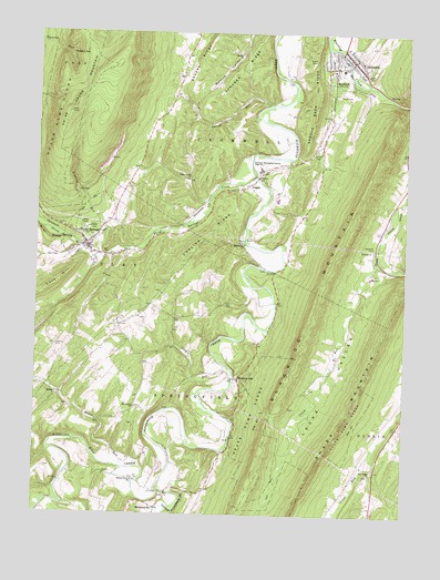
Orbisonia, PA USGS Topographic Map
Click on map above to begin viewing in our Map Viewer.

This topographic map contains these locations and features:
Feature Name Type Latitude Longitude GNIS ID View Map
Baker Family CemeteryCemeteryN40.1661°W77.9345°2026385View Map
Baptist Church CemeteryCemeteryN40.1763°W77.9647°1847170View Map
Beers Farm AirportAirportN40.2301°W77.9190°1193880View Map
Booth Family CemeteryCemeteryN40.1370°W77.9960°2026386View Map
Borough of OrbisoniaCivilN40.2429°W77.8930°1215275View Map
Borough of RockhillCivilN40.2411°W77.8995°1215277View Map
Borough of Three SpringsCivilN40.1970°W77.9819°1215281View Map
Chilcoat Family CemeteryCemeteryN40.2081°W77.9197°2026371View Map
Chilcote CornerLocaleN40.1662°W77.9625°1213040View Map
Craig RunStreamN40.1929°W77.8844°1172601View Map
Duffey Family CemeteryCemeteryN40.1849°W77.9183°2026384View Map
Elliot RunStreamN40.1373°W77.9692°1174148View Map
Fair Ridge ChurchChurchN40.1359°W77.8853°1174412View Map
Fair Ridge Church CemeteryCemeteryN40.1357°W77.8858°1847165View Map
Flasher Family CemeteryCemeteryN40.2157°W77.9390°2026383View Map
Frehn BridgeBridgeN40.1333°W77.9908°2709856View Map
Hill Valley Church (historical)ChurchN40.2473°W77.9478°1197013View Map
Hoopers GapGapN40.2442°W77.9894°1177364View Map
IBM Distribution Center HeliportAirportN40.2001°W77.9900°1213751View Map
Jefferson SchoolSchoolN40.2084°W77.9183°1197008View Map
Johnson RidgeRidgeN40.2404°W77.9317°1178119View Map
Jordan CemeteryCemeteryN40.2196°W77.9052°1178162View Map
Kyler Family CemeteryCemeteryN40.1969°W77.9577°2026372View Map
Laurel Grove SchoolSchoolN40.1920°W77.9739°1197005View Map
Laurel RunStreamN40.2315°W77.9214°1178979View Map
Lick RunStreamN40.1634°W77.9342°1198083View Map
Little Aughwick CreekStreamN40.1329°W77.9572°1179457View Map
Locke CemeteryCemeteryN40.1577°W77.9068°1847164View Map
Locke ValleyValleyN40.1889°W77.8859°1179759View Map
Madden SchoolSchoolN40.1645°W77.9731°1197003View Map
MaddensvillePopulated PlaceN40.1268°W77.9581°1180173View Map
Maddensville CemeteryCemeteryN40.1305°W77.9565°1847166View Map
McKendree ChurchChurchN40.1954°W77.9292°1180748View Map
McKendree Methodist Church CemeteryCemeteryN40.1959°W77.9300°1847163View Map
Meadow GapPopulated PlaceN40.1601°W77.9308°1180820View Map
Memmi AirportAirportN40.1686°W77.9926°1193856View Map
MentzerPopulated PlaceN40.1254°W77.8850°1197011View Map
Monroe ChurchChurchN40.2451°W77.9317°1181433View Map
Monroe Church CemeteryCemeteryN40.2454°W77.9321°1847173View Map
Mount Carmel ChurchChurchN40.1529°W77.9656°1181672View Map
North Spring BranchStreamN40.1929°W77.9842°1182637View Map
Old Baptist ChurchSchoolN40.1765°W77.9647°1197004View Map
Old Logan CemeteryCemeteryN40.2079°W77.8778°1988418View Map
OrbisoniaPopulated PlaceN40.2429°W77.8931°1183018View Map
Orbisonia / Rockhill Volunteer Fire Company Station 9BuildingN40.2434°W77.8927°2645441View Map
Orbisonia CemeteryCemeteryN40.2440°W77.8909°1847161View Map
Orbisonia Post OfficePost OfficeN40.2405°W77.8916°2772894View Map
Pleasant Bank School (historical)SchoolN40.1292°W77.9911°1197002View Map
Pleasant Hill SchoolSchoolN40.1484°W77.8767°1197010View Map
PoguePopulated PlaceN40.2106°W77.9281°1184167View Map
Price CemeteryCemeteryN40.2020°W77.9482°1847172View Map
Ramsey Family CemeteryCemeteryN40.1454°W77.9398°2026387View Map
RockhillPopulated PlaceN40.2417°W77.8997°1185308View Map
Rockhill Furnace Post OfficePost OfficeN40.2411°W77.8985°2773250View Map
Rockhill Independent Order of Odd Fellows CemeteryCemeteryN40.2344°W77.8981°1847162View Map
Saddle Back RidgeRidgeN40.2342°W77.9064°1185708View Map
Saint Mary's CemeteryCemeteryN40.2065°W77.8783°1988417View Map
Saint Mary's Covered BridgeBridgeN40.2058°W77.8778°2709858View Map
Saint Marys Church (historical)ChurchN40.2062°W77.8783°1197009View Map
SeleaPopulated PlaceN40.1559°W77.9917°1204609View Map
Shopes RidgeRidgeN40.2426°W77.9461°1187588View Map
Sideling Hill CreekStreamN40.1329°W77.9572°1193361View Map
Sinking RunStreamN40.1923°W77.9764°1187718View Map
Southern Huntingdon County High SchoolSchoolN40.2148°W77.9242°1188126View Map
Spring CreekStreamN40.1929°W77.9842°1188216View Map
State Game Lands Number 81ParkN40.1490°W77.9253°1193460View Map
State Game Lands Number 99ParkN40.2304°W77.9928°1188544View Map
Sugar Grove ChurchChurchN40.2120°W77.9489°1188935View Map
Sugar Grove SchoolSchoolN40.2123°W77.9511°1197006View Map
Three SpringsPopulated PlaceN40.1951°W77.9831°1189544View Map
Three Springs Area Ambulance Service 1200BuildingN40.1951°W77.9823°2719527View Map
Three Springs CemeteryCemeteryN40.1971°W77.9781°1847171View Map
Three Springs CreekStreamN40.2137°W77.9261°1189546View Map
Three Springs Post OfficePost OfficeN40.1941°W77.9825°2773001View Map
Three Springs Volunteer Fire Company Station 12BuildingN40.1938°W77.9828°2644993View Map
Township of CromwellCivilN40.2430°W77.9090°1216506View Map
Township of SpringfieldCivilN40.1477°W77.9479°1216521View Map
Walnut Grove ChurchChurchN40.1337°W77.9658°1190543View Map
Walnut Grove Church CemeteryCemeteryN40.1338°W77.9661°1847167View Map
Whitsel School (historical)SchoolN40.2498°W77.9464°1197012View Map
Wible CemeteryCemeteryN40.1478°W77.9679°1847169View Map
Wible CornerLocaleN40.1740°W77.9703°1213041View Map
Wood-Cutting SchoolSchoolN40.1767°W77.9442°1197007View Map

Note: Coordinates in the location and feature list above are referenced to NAD83 datum.


Copyright (C) 2008-2025 Ryan Niemi / Sunset Dynamics ... All Rights Reserved