TopoQuest Logo
Do you find TopoQuest useful?
Help keep TopoQuest running and adding new maps/features by donating!
Bitcoin:  19c7KJd3qBynnjoSw5npx9KScwjBe4ifkT
Litecoin:  LXs6TkuXGGXo1vDsWCkWVdjQX94eUKd6ui
Home View Maps Find Maps Find Places Resources & Links


Tazewell North, Virginia Topographic Map

USGS Map Title: Tazewell North, VA
USGS Map MRC: 37081B5
DRG (GeoTIFF) Download: o37081b5.tif


Neighboring USGS Topographic Map Quads:


  War, WV  
37081C6
 

  Gary, WV  
37081C5
 

  Anawalt, WV  
37081C4
 

  Amonate, VA  
37081B6
 

  Tazewell North, VA  
37081B5
 

  Tiptop, VA  
37081B4
 

  Pounding Mill, VA  
37081A6
 

  Tazewell South, VA  
37081A5
 

  Hutchinson Rock, VA  
37081A4


Map MRC Location:

N38°
W82°
N38°
W81°
H8 H7 H6 H5 H4 H3 H2 H1
G8 G7 G6 G5 G4 G3 G2 G1
F8 F7 F6 F5 F4 F3 F2 F1
E8 E7 E6 E5 E4 E3 E2 E1
D8 D7 D6 D5 D4 D3 D2 D1
C8 C7 C6 C5 C4 C3 C2 C1
B8 B7 B6 B5 B4 B3 B2 B1
A8 A7 A6 A5 A4 A3 A2 A1
N37°
W82°
N37°
W81°

Tazewell North, VA USGS 1:24K Topographic Map Preview:
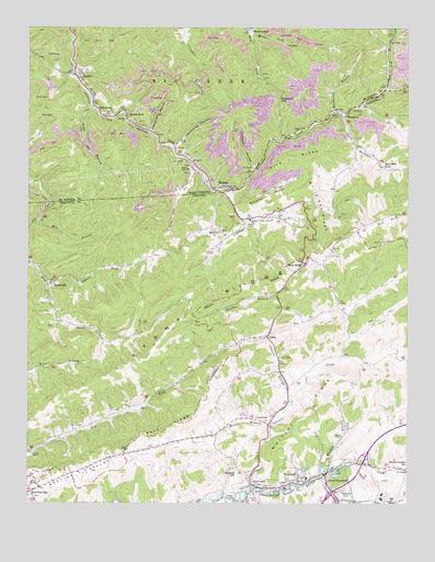
Tazewell North, VA USGS Topographic Map
Click on map above to begin viewing in our Map Viewer.

This topographic map contains these locations and features:
Feature Name Type Latitude Longitude GNIS ID View Map
AdriaPopulated PlaceN37.1687°W81.5459°1462375View Map
Baptist Valley Volunteer Fire DepartmentBuildingN37.1365°W81.5988°2085880View Map
Berwind Volunteer Fire Department Station 2BuildingN37.2395°W81.6092°2577828View Map
Big Stone RidgeRidgeN37.1787°W81.5807°1497605View Map
Billips School (historical)SchoolN37.2440°W81.5721°1689216View Map
BishopPopulated PlaceN37.2084°W81.5601°1553909View Map
Bishop Post OfficePost OfficeN37.2002°W81.5549°2766158View Map
Bishop Prep Plant Slurry ImpoundmentReservoirN37.1972°W81.5793°1558987View Map
Bishop SchoolSchoolN37.1998°W81.5518°1463465View Map
Bishop Volunteer Fire DepartmentBuildingN37.2067°W81.5599°2085879View Map
Bowman School (historical)SchoolN37.2404°W81.5068°1689218View Map
Brewster HollowValleyN37.2034°W81.5568°1463796View Map
BrewsterdalePopulated PlaceN37.2493°W81.5515°1553975View Map
Brown ChurchChurchN37.1912°W81.5243°1463906View Map
Burkes Garden StationLocaleN37.1346°W81.5021°1464113View Map
Cavitts CreekStreamN37.1293°W81.5509°1464577View Map
Crockett CoveBasinN37.1993°W81.5529°1465443View Map
Dailey ChapelChurchN37.1384°W81.5929°1495451View Map
Dalton Branch DamDamN37.2068°W81.5765°1558986View Map
Deadman HollowValleyN37.2237°W81.5851°1538090View Map
Dick Creek ChurchChurchN37.1698°W81.6009°1497629View Map
Dicks Creek - Amonate - Dry Fork Volunteer Fire DepartmentBuildingN37.1818°W81.6188°2085882View Map
Dix CreekStreamN37.1879°W81.6243°1491080View Map
Dogwood GapGapN37.2315°W81.5426°1538249View Map
Endwell ChurchChurchN37.2265°W81.5929°1538711View Map
Ferguson BranchStreamN37.2298°W81.5159°1483405View Map
Gap Store (historical)LocaleN37.1293°W81.6207°1497643View Map
Goose CreekStreamN37.2137°W81.5079°1483707View Map
Grassy Spur ChurchChurchN37.1968°W81.5632°1467376View Map
Harman Church (historical)ChurchN37.1646°W81.5204°1497653View Map
Healing Springs School (historical)SchoolN37.1779°W81.5223°1497654View Map
HorsepenPopulated PlaceN37.2282°W81.5198°1499578View Map
Horsepen CovePopulated PlaceN37.2137°W81.5079°1499579View Map
Horsepen CreekStreamN37.2087°W81.5579°1484226View Map
Horsepen CreekStreamN37.2082°W81.5584°1540504View Map
Horsepen Post OfficePost OfficeN37.2186°W81.5166°2766225View Map
Horsepen School (historical)SchoolN37.2204°W81.5168°1497659View Map
Hubble HillSummitN37.1332°W81.5562°1499583View Map
Jacobs ForkPopulated PlaceN37.2279°W81.5929°1554793View Map
Jailhouse HollowValleyN37.2190°W81.5768°1540795View Map
Johnson BranchStreamN37.1540°W81.5387°1468775View Map
Johnson HollowValleyN37.2131°W81.5507°1540983View Map
JohnstownPopulated PlaceN37.2271°W81.5987°1554823View Map
Laurel ForkStreamN37.1837°W81.6184°1469175View Map
Lincolnshire BranchStreamN37.1332°W81.5004°1484850View Map
Linkous ChapelChurchN37.1382°W81.6234°1469444View Map
Linkous School (historical)SchoolN37.1462°W81.6034°1497677View Map
Little Horsepen CreekStreamN37.2268°W81.5215°1469561View Map
Little Stone RidgeRidgeN37.1565°W81.6032°1497679View Map
Litz ChapelChurchN37.1637°W81.5418°1469704View Map
Low Gap BranchStreamN37.2340°W81.5076°1542501View Map
Low Gap BranchStreamN37.2343°W81.5076°1469896View Map
Maplewood CemeteryCemeteryN37.1268°W81.5209°1470083View Map
McCall PlacePopulated PlaceN37.1918°W81.5815°1497688View Map
Middle Fork Big CreekStreamN37.2490°W81.5529°1543171View Map
Mile BranchStreamN37.1996°W81.6204°1470454View Map
Mundy BranchStreamN37.1454°W81.5451°1471266View Map
North Fork Big CreekStreamN37.2490°W81.5529°1544201View Map
North TazewellPopulated PlaceN37.1329°W81.5271°1499807View Map
North Tazewell Elementary SchoolSchoolN37.1317°W81.5329°1497697View Map
North Tazewell Post OfficePost OfficeN37.1334°W81.5273°1497698View Map
Northern DistrictCivilN37.2075°W81.5278°1927429View Map
Pine RidgeRidgeN37.2162°W81.5384°1472366View Map
River JackPopulated PlaceN37.1301°W81.5507°1473263View Map
Road ForkStreamN37.2479°W81.5518°1545798View Map
Rockhouse BranchStreamN37.2279°W81.5246°1545962View Map
Rourkes GapPopulated PlaceN37.1279°W81.6232°1499997View Map
Sandy RidgeRidgeN37.1451°W81.5787°1474041View Map
SayersvillePopulated PlaceN37.1829°W81.6179°1500034View Map
ShradersPopulated PlaceN37.1996°W81.5543°1497733View Map
SquirePopulated PlaceN37.2384°W81.6098°1547294View Map
Squire Post OfficePost OfficeN37.2393°W81.6097°2774609View Map
Stony RidgePopulated PlaceN37.1884°W81.5337°1500172View Map
Tazewell Christian AcademySchoolN37.1344°W81.5057°2498420View Map
Tazewell County Career and Technical CenterSchoolN37.1276°W81.5082°2498454View Map
Tazewell Elementary SchoolSchoolN37.1267°W81.5088°2498418View Map
Tazewell High SchoolSchoolN37.1250°W81.5053°1497752View Map
Town of TazewellCivilN37.1270°W81.5130°2391440View Map
Trace BranchStreamN37.2298°W81.6040°1548186View Map
White Oak RidgeRidgeN37.2048°W81.5298°1476616View Map
Whitley BranchStreamN37.1346°W81.5248°1476683View Map
Whitley RidgeRidgeN37.1484°W81.5332°1476685View Map
Willow BridgeBridgeN37.1687°W81.5457°1497766View Map
WTZE-FM (Tazewell)TowerN37.1334°W81.5951°1502717View Map

Note: Coordinates in the location and feature list above are referenced to NAD83 datum.


Copyright (C) 2008-2024 Ryan Niemi / Sunset Dynamics ... All Rights Reserved