TopoQuest Logo
Do you find TopoQuest useful?
Help keep TopoQuest running and adding new maps/features by donating!
Bitcoin:  19c7KJd3qBynnjoSw5npx9KScwjBe4ifkT
Litecoin:  LXs6TkuXGGXo1vDsWCkWVdjQX94eUKd6ui
Home View Maps Find Maps Find Places Resources & Links


Huxley, Texas Topographic Map

USGS Map Title: Huxley, TX
USGS Map MRC: 31093G8
DRG (GeoTIFF) Download: o31093g8.tif


Neighboring USGS Topographic Map Quads:


  Logansport West, LA  
31094H1
 

  Logansport East, LA  
31093H8
 

  Hunter, LA  
31093H7
 

  Shelbyville, TX  
31094G1
 

  Huxley, TX  
31093G8
 

  Union Springs, LA  
31093G7
 

  Hurstown, TX  
31094F1
 

  Patroon North, TX  
31093F8
 

  Brushy Creek, TX  
31093F7


Map MRC Location:

N32°
W94°
N32°
W93°
H8 H7 H6 H5 H4 H3 H2 H1
G8 G7 G6 G5 G4 G3 G2 G1
F8 F7 F6 F5 F4 F3 F2 F1
E8 E7 E6 E5 E4 E3 E2 E1
D8 D7 D6 D5 D4 D3 D2 D1
C8 C7 C6 C5 C4 C3 C2 C1
B8 B7 B6 B5 B4 B3 B2 B1
A8 A7 A6 A5 A4 A3 A2 A1
N31°
W94°
N31°
W93°

Huxley, TX USGS 1:24K Topographic Map Preview:
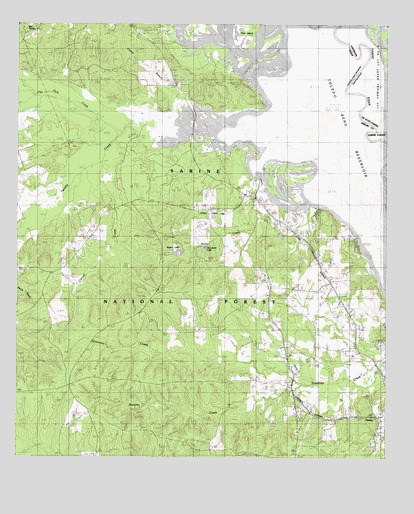
Huxley, TX USGS Topographic Map
Click on map above to begin viewing in our Map Viewer.

This topographic map contains these locations and features:
Feature Name Type Latitude Longitude GNIS ID View Map
Ashton CemeteryCemeteryN31.8735°W93.9980°1381339View Map
Boles FieldLocaleN31.7724°W93.9594°1381482View Map
Brawley CreekStreamN31.7707°W93.9035°1381505View Map
Caney BranchStreamN31.8488°W93.9432°1381577View Map
Carroll CemeteryCemeteryN31.8299°W93.9652°1381597View Map
Carroll CreekStreamN31.8418°W93.9671°1381598View Map
Carrolltown ChurchChurchN31.8046°W93.9966°1381599View Map
City of HuxleyCivilN31.7720°W93.9139°2410086View Map
Flat Fork CreekStreamN31.8496°W93.9555°1383094View Map
Goodsons LakeLakeN31.8103°W93.9367°1381927View Map
Holly Springs CemeteryCemeteryN31.7530°W93.9838°1384849View Map
Horseshoe LakeSwampN31.8674°W93.9199°1382034View Map
HuxleyPopulated PlaceN31.7624°W93.8771°1382055View Map
Lydia ChurchChurchN31.8004°W93.9135°1382211View Map
Mason LakeLakeN31.8093°W93.9458°1889975View Map
National Forest SpringSpringN31.7752°W93.9752°1998335View Map
Old River LakeLakeN31.8382°W93.8771°1382429View Map
Pauls CreekStreamN31.8410°W93.9202°1382465View Map
Pauls StoreLocaleN31.8246°W93.9180°1382466View Map
Rayborn ChurchChurchN31.8068°W93.8977°1382599View Map
Strong CemeteryCemeteryN31.7577°W93.9044°1382818View Map
Tenaha BayouStreamN31.8299°W93.8755°1382849View Map
Tenaha CreekStreamN31.8418°W93.9669°1382850View Map
Tenaha Lookout TowerTowerN31.8129°W93.9502°1384692View Map
Tuckers LakeLakeN31.8616°W93.9055°1382886View Map
Turkey CreekStreamN31.8696°W93.8838°548096View Map
Wildcat BendBendN31.8741°W93.9006°548148View Map
Wimberly CemeteryCemeteryN31.8063°W93.8982°1382982View Map

Note: Coordinates in the location and feature list above are referenced to NAD83 datum.


Copyright (C) 2008-2025 Ryan Niemi / Sunset Dynamics ... All Rights Reserved