TopoQuest Logo
Do you find TopoQuest useful?
Help keep TopoQuest running and adding new maps/features by donating!
Bitcoin:  19c7KJd3qBynnjoSw5npx9KScwjBe4ifkT
Litecoin:  LXs6TkuXGGXo1vDsWCkWVdjQX94eUKd6ui
Home View Maps Find Maps Find Places Resources & Links


Shelbyville, Texas Topographic Map

USGS Map Title: Shelbyville, TX
USGS Map MRC: 31094G1
DRG (GeoTIFF) Download: o31094g1.tif


Neighboring USGS Topographic Map Quads:


  Tenaha East, TX  
31094H2
 

  Logansport West, LA  
31094H1
 

  Logansport East, LA  
31093H8
 

  Center, TX  
31094G2
 

  Shelbyville, TX  
31094G1
 

  Huxley, TX  
31093G8
 

  Neuville, TX  
31094F2
 

  Hurstown, TX  
31094F1
 

  Patroon North, TX  
31093F8


Map MRC Location:

N32°
W95°
N32°
W94°
H8 H7 H6 H5 H4 H3 H2 H1
G8 G7 G6 G5 G4 G3 G2 G1
F8 F7 F6 F5 F4 F3 F2 F1
E8 E7 E6 E5 E4 E3 E2 E1
D8 D7 D6 D5 D4 D3 D2 D1
C8 C7 C6 C5 C4 C3 C2 C1
B8 B7 B6 B5 B4 B3 B2 B1
A8 A7 A6 A5 A4 A3 A2 A1
N31°
W95°
N31°
W94°

Shelbyville, TX USGS 1:24K Topographic Map Preview:
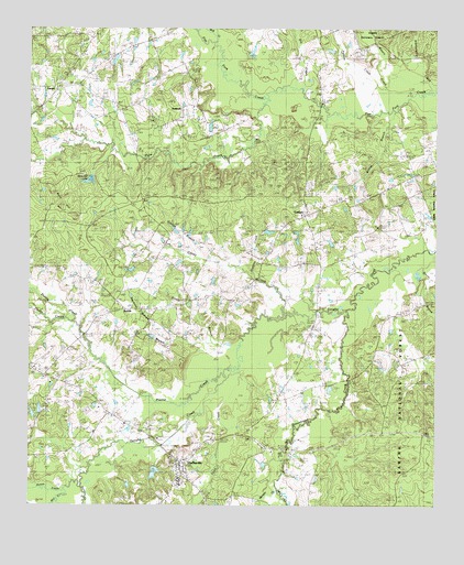
Shelbyville, TX USGS Topographic Map
Click on map above to begin viewing in our Map Viewer.

This topographic map contains these locations and features:
Feature Name Type Latitude Longitude GNIS ID View Map
AntiochPopulated PlaceN31.8543°W94.0771°1379353View Map
Antioch ChurchChurchN31.8554°W94.0916°1351202View Map
Beauchamp CreekStreamN31.8002°W94.0271°1351710View Map
Bell CreekStreamN31.7560°W94.0485°1351833View Map
Bivens BranchStreamN31.8157°W94.0069°1352269View Map
Blankenship CreekStreamN31.8593°W94.0019°1352403View Map
Bone HillSummitN31.8316°W94.1174°1352641View Map
Bone Hill LakeReservoirN31.8354°W94.1064°1352642View Map
Bone Hill Lake DamDamN31.8352°W94.1052°1854857View Map
CamptiPopulated PlaceN31.8263°W94.0402°1379497View Map
Caney CreekStreamN31.8007°W94.0457°1353729View Map
Carls ChapelChurchN31.7674°W94.0555°1353825View Map
Carlyle BranchStreamN31.8149°W94.0710°1353828View Map
Clark CreekStreamN31.7699°W94.0419°1381115View Map
Cooney CreekStreamN31.8102°W94.0546°1354939View Map
Cuba ChurchChurchN31.8368°W94.0077°1355458View Map
Dry CreekStreamN31.8557°W94.0366°1356333View Map
Good Hope ChurchChurchN31.7838°W94.1196°1358149View Map
Hawkeye Hunt ClubLocaleN31.7752°W94.1196°1384569View Map
Huana CreekStreamN31.7535°W94.1099°1374167View Map
JamesPopulated PlaceN31.8593°W94.1158°1379996View Map
Mill CreekStreamN31.7521°W94.1149°1374936View Map
Morrison CreekStreamN31.7560°W94.0488°1363167View Map
Plum CreekStreamN31.8552°W94.0516°1365472View Map
Porter CreekStreamN31.7535°W94.1099°1365602View Map
Prairie CreekStreamN31.7793°W94.0719°1365722View Map
Price CemeteryCemeteryN31.8116°W94.0232°1365770View Map
Price CemeteryCemeteryN31.8702°W94.0360°1365771View Map
SardisPopulated PlaceN31.8018°W94.0941°1380497View Map
Sardis BranchStreamN31.7899°W94.0591°1367774View Map
Seymour Watson BranchStreamN31.7916°W94.0663°1368009View Map
ShelbyvillePopulated PlaceN31.7616°W94.0785°1368105View Map
Shelbyville Post OfficePost OfficeN31.7591°W94.0789°2731166View Map
Shelbyville Volunteer Fire DepartmentBuildingN31.7582°W94.0785°2655627View Map
Smith CemeteryCemeteryN31.8704°W94.1085°1368473View Map
Talbert CreekStreamN31.8593°W94.0149°1369560View Map
Town CreekStreamN31.7849°W94.0602°1354563View Map
Watery CreekStreamN31.8554°W94.0116°1370928View Map
Willsie BranchStreamN31.8532°W94.0127°1371697View Map
Windham LakeReservoirN31.7586°W94.0865°1854860View Map
Windham Lake DamDamN31.7602°W94.0869°1854859View Map
Wolf CreekStreamN31.8724°W94.0688°1371838View Map

Note: Coordinates in the location and feature list above are referenced to NAD83 datum.


Copyright (C) 2008-2024 Ryan Niemi / Sunset Dynamics ... All Rights Reserved