TopoQuest Logo
Do you find TopoQuest useful?
Help keep TopoQuest running and adding new maps/features by donating!
Bitcoin:  19c7KJd3qBynnjoSw5npx9KScwjBe4ifkT
Litecoin:  LXs6TkuXGGXo1vDsWCkWVdjQX94eUKd6ui
Home View Maps Find Maps Find Places Resources & Links


Hurstown, Texas Topographic Map

USGS Map Title: Hurstown, TX
USGS Map MRC: 31094F1
DRG (GeoTIFF) Download: o31094f1.tif


Neighboring USGS Topographic Map Quads:


  Center, TX  
31094G2
 

  Shelbyville, TX  
31094G1
 

  Huxley, TX  
31093G8
 

  Neuville, TX  
31094F2
 

  Hurstown, TX  
31094F1
 

  Patroon North, TX  
31093F8
 

  San Augustine West, TX  
31094E2
 

  San Augustine East, TX  
31094E1
 

  Patroon South, TX  
31093E8


Map MRC Location:

N32°
W95°
N32°
W94°
H8 H7 H6 H5 H4 H3 H2 H1
G8 G7 G6 G5 G4 G3 G2 G1
F8 F7 F6 F5 F4 F3 F2 F1
E8 E7 E6 E5 E4 E3 E2 E1
D8 D7 D6 D5 D4 D3 D2 D1
C8 C7 C6 C5 C4 C3 C2 C1
B8 B7 B6 B5 B4 B3 B2 B1
A8 A7 A6 A5 A4 A3 A2 A1
N31°
W95°
N31°
W94°

Hurstown, TX USGS 1:24K Topographic Map Preview:
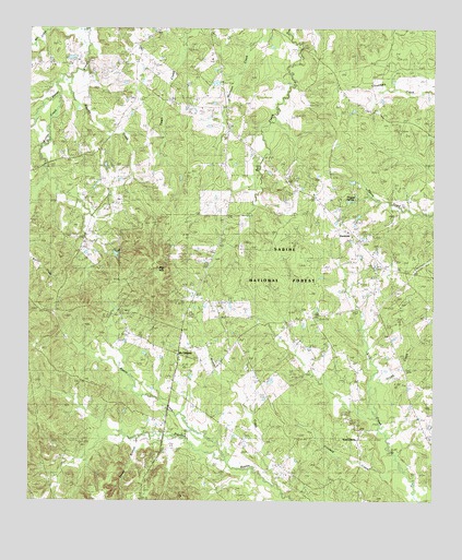
Hurstown, TX USGS Topographic Map
Click on map above to begin viewing in our Map Viewer.

This topographic map contains these locations and features:
Feature Name Type Latitude Longitude GNIS ID View Map
Adams CemeteryCemeteryN31.6843°W94.0730°1350868View Map
Big HillSummitN31.6866°W94.0846°1381427View Map
Biggers CemeteryCemeteryN31.7255°W94.0980°1381436View Map
Biggers CreekStreamN31.7366°W94.1108°1381437View Map
Butler CreekStreamN31.7016°W94.1241°1381562View Map
Cannon CemeteryCemeteryN31.7288°W94.0688°1381590View Map
Center Ridge CemeteryCemeteryN31.7164°W94.1067°1381618View Map
Creech CemeteryCemeteryN31.7094°W94.1066°1381715View Map
Crooked CreekStreamN31.6332°W94.0138°1381719View Map
Daugherty CemeteryCemeteryN31.7235°W94.0110°1381739View Map
Davis RanchLocaleN31.7071°W94.0060°1381743View Map
Doggett SpringSpringN31.7049°W94.0273°1356130View Map
East LibertyPopulated PlaceN31.6680°W94.0330°1381820View Map
East LibertyPopulated PlaceN31.6413°W94.0238°1889817View Map
East Liberty CemeteryCemeteryN31.6274°W94.0224°1381821View Map
East Liberty ChurchChurchN31.6396°W94.0232°1381822View Map
East Liberty SchoolSchoolN31.6749°W94.0394°1381823View Map
Ephesus ChurchChurchN31.6941°W94.0227°1381847View Map
Grubb CreekStreamN31.6502°W94.0191°1381951View Map
HurstownPopulated PlaceN31.6971°W94.0291°1382054View Map
McClellandPopulated PlaceN31.6635°W94.0780°1382253View Map
McWilliams CemeteryCemeteryN31.7066°W94.0591°1382272View Map
Neuville CemeteryCemeteryN31.6757°W94.1219°1382377View Map
Neuville SchoolSchoolN31.6255°W94.1219°1382378View Map
Neuvine CemeteryCemeteryN31.6752°W94.1246°1383777View Map
Palestine ChurchChurchN31.7071°W94.0996°1382448View Map
Rascal CreekStreamN31.6357°W94.0635°1382592View Map
Rather CemeteryCemeteryN31.6888°W94.0169°1382595View Map
Sample CemeteryCemeteryN31.7393°W94.0077°1382691View Map
Sandy BranchStreamN31.6416°W94.0802°1382706View Map
Todd Springs ChurchChurchN31.7177°W94.0646°1382869View Map
Wooten CreekStreamN31.6288°W94.0482°1382997View Map

Note: Coordinates in the location and feature list above are referenced to NAD83 datum.


Copyright (C) 2008-2024 Ryan Niemi / Sunset Dynamics ... All Rights Reserved