TopoQuest Logo
Do you find TopoQuest useful?
Help keep TopoQuest running and adding new maps/features by donating!
Bitcoin:  19c7KJd3qBynnjoSw5npx9KScwjBe4ifkT
Litecoin:  LXs6TkuXGGXo1vDsWCkWVdjQX94eUKd6ui
Home View Maps Find Maps Find Places Resources & Links


Hybart, Alabama Topographic Map

USGS Map Title: Hybart, AL
USGS Map MRC: 31087G4
DRG (GeoTIFF) Download: o31087g4.tif


Neighboring USGS Topographic Map Quads:


  Pine Hill, AL  
31087H5
 

  Coy, AL  
31087H4
 

  Camden South, AL  
31087H3
 

  Lower Peach Tree, AL  
31087G5
 

  Hybart, AL  
31087G4
 

  Vredenburgh, AL  
31087G3
 

  Chance, AL  
31087F5
 

  Franklin, AL  
31087F4
 

  Natchez, AL  
31087F3


Map MRC Location:

N32°
W88°
N32°
W87°
H8 H7 H6 H5 H4 H3 H2 H1
G8 G7 G6 G5 G4 G3 G2 G1
F8 F7 F6 F5 F4 F3 F2 F1
E8 E7 E6 E5 E4 E3 E2 E1
D8 D7 D6 D5 D4 D3 D2 D1
C8 C7 C6 C5 C4 C3 C2 C1
B8 B7 B6 B5 B4 B3 B2 B1
A8 A7 A6 A5 A4 A3 A2 A1
N31°
W88°
N31°
W87°

Hybart, AL USGS 1:24K Topographic Map Preview:
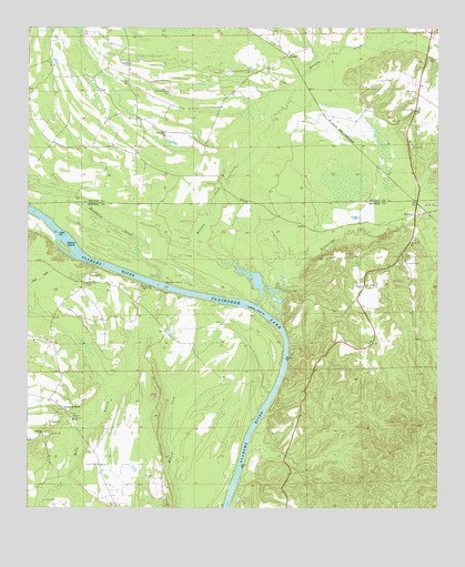
Hybart, AL USGS Topographic Map
Click on map above to begin viewing in our Map Viewer.

This topographic map contains these locations and features:
Feature Name Type Latitude Longitude GNIS ID View Map
Adams Store (historical)LocaleN31.7632°W87.4783°136475View Map
AsahelPopulated PlaceN31.8679°W87.4208°156004View Map
Backers LandingLocaleN31.8085°W87.4578°156010View Map
Belle Landing (historical)LocaleN31.7968°W87.4217°154124View Map
Bells Landing ChurchChurchN31.8057°W87.3989°154575View Map
Bells Landing ParkParkN31.8071°W87.4217°136485View Map
Bells Landing Presbyterian ChurchChurchN31.8079°W87.3969°154125View Map
Buckhorn CreekStreamN31.8099°W87.4622°115144View Map
Burntwood BranchStreamN31.8329°W87.4417°138441View Map
Greater Bells ChapelChurchN31.8088°W87.4825°155082View Map
Holly BranchStreamN31.7529°W87.4955°120267View Map
HybartPopulated PlaceN31.8265°W87.3819°151844View Map
Hybart CemeteryCemeteryN31.8135°W87.3847°120608View Map
Independent ChurchChurchN31.7738°W87.4867°154574View Map
Jones ChapelChurchN31.7615°W87.4783°120999View Map
Kings Log LandingLocaleN31.8079°W87.4617°156559View Map
Lambert LandingLocaleN31.8052°W87.4519°136549View Map
Little Zion Number 1 Baptist ChurchChurchN31.8089°W87.3874°2580394View Map
McCalls CreekStreamN31.8029°W87.4294°152261View Map
McCarty CemeteryCemeteryN31.8576°W87.3836°122467View Map
Monroe Senior High SchoolSchoolN31.7729°W87.4861°165610View Map
Morrisette LandingLocaleN31.7704°W87.4328°136578View Map
Morrisons Ferry (historical)CrossingN31.8007°W87.4264°136579View Map
Mount Gilead ChurchChurchN31.8468°W87.4583°123194View Map
Mount Sinai ChurchChurchN31.7690°W87.4953°123390View Map
Nettles Chapel (historical)ChurchN31.8513°W87.4675°138534View Map
New Providence CemeteryCemeteryN31.8588°W87.4561°152670View Map
Packards BendPopulated PlaceN31.7760°W87.4894°156851View Map
Packards Bend School (historical)SchoolN31.7774°W87.4905°136598View Map
Pine Flat Baptist ChurchChurchN31.8196°W87.3828°124766View Map
Pine Flat CemeteryCemeteryN31.8199°W87.3825°1805552View Map
Powell CemeteryCemeteryN31.7582°W87.4617°125221View Map
Saint James BarBarN31.8040°W87.4333°136621View Map
Saint James LandingLocaleN31.8021°W87.4280°136622View Map
Saint Peter Church (historical)ChurchN31.8535°W87.4911°138578View Map
Steins IslandIslandN31.8179°W87.4889°153565View Map
Tallatchee CreekStreamN31.7985°W87.4228°153644View Map
TinelaPopulated PlaceN31.8085°W87.3972°157161View Map
Tinela CemeteryCemeteryN31.8076°W87.3961°1805553View Map

Note: Coordinates in the location and feature list above are referenced to NAD83 datum.


Copyright (C) 2008-2025 Ryan Niemi / Sunset Dynamics ... All Rights Reserved