TopoQuest Logo
Do you find TopoQuest useful?
Help keep TopoQuest running and adding new maps/features by donating!
Bitcoin:  19c7KJd3qBynnjoSw5npx9KScwjBe4ifkT
Litecoin:  LXs6TkuXGGXo1vDsWCkWVdjQX94eUKd6ui
Home View Maps Find Maps Find Places Resources & Links


Pine Hill, Alabama Topographic Map

USGS Map Title: Pine Hill, AL
USGS Map MRC: 31087H5
DRG (GeoTIFF) Download: o31087h5.tif


Neighboring USGS Topographic Map Quads:


  Surginer, AL  
32087A6
 

  Kimbrough, AL  
32087A5
 

  Lee Long Bridge, AL  
32087A4
 

  Thomasville, AL  
31087H6
 

  Pine Hill, AL  
31087H5
 

  Coy, AL  
31087H4
 

  Fulton East, AL  
31087G6
 

  Lower Peach Tree, AL  
31087G5
 

  Hybart, AL  
31087G4


Map MRC Location:

N32°
W88°
N32°
W87°
H8 H7 H6 H5 H4 H3 H2 H1
G8 G7 G6 G5 G4 G3 G2 G1
F8 F7 F6 F5 F4 F3 F2 F1
E8 E7 E6 E5 E4 E3 E2 E1
D8 D7 D6 D5 D4 D3 D2 D1
C8 C7 C6 C5 C4 C3 C2 C1
B8 B7 B6 B5 B4 B3 B2 B1
A8 A7 A6 A5 A4 A3 A2 A1
N31°
W88°
N31°
W87°

Pine Hill, AL USGS 1:24K Topographic Map Preview:
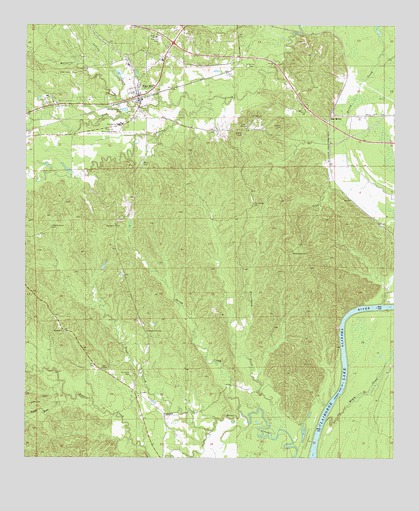
Pine Hill, AL USGS Topographic Map
Click on map above to begin viewing in our Map Viewer.

This topographic map contains these locations and features:
Feature Name Type Latitude Longitude GNIS ID View Map
Bethel CemeteryCemeteryN31.9710°W87.5511°114014View Map
Bethel Church (historical)ChurchN31.9676°W87.5511°138432View Map
Black CreekStreamN31.8857°W87.5231°114416View Map
Burntwood CreekStreamN31.8832°W87.5383°115271View Map
Caney CreekStreamN31.8885°W87.5522°115574View Map
Caney Creek School (historical)SchoolN31.9438°W87.5922°138446View Map
Cub CreekStreamN31.9760°W87.5672°116944View Map
CulpeperPopulated PlaceN31.8871°W87.5775°156238View Map
Enon CemeteryCemeteryN31.9865°W87.6103°117999View Map
Enon CemeteryCemeteryN31.9885°W87.5497°158386View Map
Enon Church (historical)ChurchN31.9868°W87.6089°138463View Map
Etta LandingLocaleN31.8882°W87.5244°138465View Map
Independence CemeteryCemeteryN31.9415°W87.6169°120624View Map
Independence Church (historical)ChurchN31.9149°W87.6161°138494View Map
Indian CreekStreamN31.9790°W87.5936°120645View Map
Kelly CemeteryCemeteryN31.9601°W87.5864°121116View Map
Lane CemeteryCemeteryN31.9110°W87.6078°158388View Map
Lane ChapelChurchN31.9007°W87.5992°121373View Map
Liberty ChurchChurchN31.9115°W87.6119°152037View Map
Little Bear CreekStreamN31.8929°W87.6111°121697View Map
MacMillanPopulated PlaceN31.9729°W87.5225°156644View Map
Moccasin CreekStreamN31.9765°W87.5894°122929View Map
Montgomery Institute (historical)SchoolN31.9410°W87.6131°138524View Map
Mount Andrew CemeteryCemeteryN31.9346°W87.5350°123139View Map
Mount Andrew Church (historical)ChurchN31.9352°W87.5344°138527View Map
Pine HillPopulated PlaceN31.9796°W87.5881°155204View Map
Pine Hill CemeteryCemeteryN31.9960°W87.5808°124810View Map
Pine Hill DivisionCivilN31.9741°W87.5600°166000View Map
Pine Hill Municipal Airport (historical)AirportN31.9688°W87.5923°129415View Map
Pine Hill Post OfficePost OfficeN31.9806°W87.5877°167583View Map
Pine Hill SchoolSchoolN31.9715°W87.5939°124818View Map
Pine Hill Volunteer Fire DepartmentBuildingN31.9883°W87.5901°2691290View Map
Pine Level School (historical)SchoolN31.9440°W87.5606°138553View Map
Pleasant View ChurchChurchN31.9118°W87.5839°125057View Map
Pleasant View Church (historical)ChurchN31.9371°W87.5519°138555View Map
Saint Johns CemeteryCemeteryN31.8996°W87.5892°126116View Map
Saint Johns ChurchChurchN31.8929°W87.5864°158917View Map
Saint Paul ChurchChurchN31.9882°W87.5517°126176View Map
Shamburger CemeteryCemeteryN31.9485°W87.5483°126624View Map
Sheffield LakeLakeN31.9863°W87.5894°138583View Map
Sheffield Mill (historical)LocaleN31.9815°W87.5453°138584View Map
Shields CemeteryCemeteryN31.9707°W87.5392°126709View Map
Stokes SchoolSchoolN31.9965°W87.5822°127426View Map
Tiger CreekStreamN31.8827°W87.5617°127976View Map
Town of Pine HillCivilN31.9859°W87.5875°2407115View Map
Yellow BluffCliffN31.9182°W87.5153°138618View Map
Yellow Bluff Ferry (historical)CrossingN31.9154°W87.5167°138619View Map
Yellow Bluff LandingLocaleN31.9138°W87.5181°138620View Map
Zion ChurchChurchN31.9710°W87.5511°158964View Map

Note: Coordinates in the location and feature list above are referenced to NAD83 datum.


Copyright (C) 2008-2025 Ryan Niemi / Sunset Dynamics ... All Rights Reserved