TopoQuest Logo
Do you find TopoQuest useful?
Help keep TopoQuest running and adding new maps/features by donating!
Bitcoin:  19c7KJd3qBynnjoSw5npx9KScwjBe4ifkT
Litecoin:  LXs6TkuXGGXo1vDsWCkWVdjQX94eUKd6ui
Home View Maps Find Maps Find Places Resources & Links


Camden South, Alabama Topographic Map

USGS Map Title: Camden South, AL
USGS Map MRC: 31087H3
DRG (GeoTIFF) Download: o31087h3.tif


Neighboring USGS Topographic Map Quads:


  Lee Long Bridge, AL  
32087A4
 

  Camden North, AL  
32087A3
 

  Tilden, AL  
32087A2
 

  Coy, AL  
31087H4
 

  Camden South, AL  
31087H3
 

  Rosebud, AL  
31087H2
 

  Hybart, AL  
31087G4
 

  Vredenburgh, AL  
31087G3
 

  Nadawah, AL  
31087G2


Map MRC Location:

N32°
W88°
N32°
W87°
H8 H7 H6 H5 H4 H3 H2 H1
G8 G7 G6 G5 G4 G3 G2 G1
F8 F7 F6 F5 F4 F3 F2 F1
E8 E7 E6 E5 E4 E3 E2 E1
D8 D7 D6 D5 D4 D3 D2 D1
C8 C7 C6 C5 C4 C3 C2 C1
B8 B7 B6 B5 B4 B3 B2 B1
A8 A7 A6 A5 A4 A3 A2 A1
N31°
W88°
N31°
W87°

Camden South, AL USGS 1:24K Topographic Map Preview:
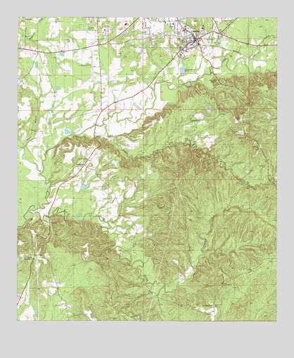
Camden South, AL USGS Topographic Map
Click on map above to begin viewing in our Map Viewer.

This topographic map contains these locations and features:
Feature Name Type Latitude Longitude GNIS ID View Map
Bones BranchStreamN31.9357°W87.3642°114722View Map
CamdenPopulated PlaceN31.9910°W87.2905°115426View Map
Camden Baptist ChurchChurchN31.9954°W87.2942°138443View Map
Camden ChurchChurchN31.9926°W87.2744°163229View Map
Camden Methodist ChurchChurchN31.9932°W87.2908°138444View Map
Camden Municipal AirportAirportN31.9798°W87.3379°129417View Map
Camden Police DepartmentBuildingN31.9914°W87.2884°2751916View Map
Camden Post OfficePost OfficeN31.9969°W87.2783°167579View Map
Camden Presbyterian ChurchChurchN31.9943°W87.2936°138445View Map
Camden Sewage LagoonReservoirN31.9768°W87.2967°130041View Map
Camden Sewage Lagoon DamDamN31.9768°W87.2967°130040View Map
Camden Volunteer Fire Department Station 1BuildingN31.9909°W87.2871°2691111View Map
Camp Camden State PrisonBuildingN31.9943°W87.3336°164299View Map
Capell CemeteryCemeteryN31.9301°W87.3330°115601View Map
Chestnut Grove Church (historical)ChurchN31.9229°W87.2853°138450View Map
Coy-Fatama DivisionCivilN31.8891°W87.3299°165998View Map
Dry Fork PlantationLocaleN31.9019°W87.3608°2702059View Map
Dry ForksPopulated PlaceN31.9015°W87.3667°156281View Map
Ernest L Dyess DamDamN31.9301°W87.3450°130025View Map
Ernest L Dyess PondReservoirN31.9303°W87.3427°130026View Map
First Episcopal ChurchChurchN31.9918°W87.2928°138469View Map
Gate Church (historical)ChurchN31.8865°W87.3108°138474View Map
Gravel CreekStreamN31.9207°W87.3680°119256View Map
Gravel Creek ChurchChurchN31.9415°W87.3419°119257View Map
Gravel Hill CemeteryCemeteryN31.8818°W87.2800°119260View Map
Gravel Hill ChurchChurchN31.8902°W87.2755°119265View Map
Grumpton HillsSummitN31.9524°W87.2672°138477View Map
Gulletts Bluff ChurchChurchN31.9007°W87.3675°119466View Map
J Paul Jones HospitalHospitalN31.9982°W87.2998°138496View Map
Little Gravel CreekStreamN31.8899°W87.3044°155135View Map
Little Rock ChurchChurchN31.9463°W87.2589°121866View Map
Lotties CreekStreamN31.9815°W87.2664°122042View Map
Magnolia CemeteryCemeteryN31.9532°W87.3655°122208View Map
McCaskill CemeteryCemeteryN31.9390°W87.2555°122468View Map
McIntosh CemeteryCemeteryN31.9829°W87.2975°122561View Map
Mount Carmel CemeteryCemeteryN31.8813°W87.2808°123165View Map
Mount Carmel Church (historical)ChurchN31.8810°W87.2808°138529View Map
Munden ParkParkN31.9957°W87.3433°123588View Map
O'lea (historical)LocaleN31.8790°W87.2800°138544View Map
Old School Presbyterian ChurchChurchN31.9938°W87.2928°138543View Map
Pebble HillPopulated PlaceN31.9390°W87.3433°156867View Map
Powell CemeteryCemeteryN31.9985°W87.3719°158391View Map
Rock West ChurchChurchN31.9996°W87.3728°138565View Map
RockwestPopulated PlaceN31.9999°W87.3717°156984View Map
Rosenwald School (historical)SchoolN31.9424°W87.2550°138570View Map
Saint James ChurchChurchN31.9507°W87.2650°126101View Map
Saint Pauls African Methodist Episcopal ChurchChurchN31.9882°W87.2939°150890View Map
Shoal CreekStreamN31.9560°W87.3347°126784View Map
Sunny School (historical)SchoolN31.8785°W87.3483°138596View Map
WCOX-AM (Camden)TowerN31.9860°W87.2880°160951View Map
West Gate Church of ChristChurchN31.9988°W87.2989°138608View Map
Wheeler Quarter CemeteryCemeteryN31.9568°W87.2908°128839View Map
Wilcox CountyCivilN31.9892°W87.3082°161591View Map
Wilcox County CourthouseBuildingN31.9913°W87.2889°138611View Map
Wilcox County High SchoolSchoolN31.9949°W87.2950°138612View Map
Wilcox County Sheriff's OfficeBuildingN31.9907°W87.2881°2752028View Map
Womens Board of United Presbyterian Church School (historical)SchoolN31.9957°W87.2861°138617View Map

Note: Coordinates in the location and feature list above are referenced to NAD83 datum.


Copyright (C) 2008-2025 Ryan Niemi / Sunset Dynamics ... All Rights Reserved