TopoQuest Logo
Do you find TopoQuest useful?
Help keep TopoQuest running and adding new maps/features by donating!
Bitcoin:  19c7KJd3qBynnjoSw5npx9KScwjBe4ifkT
Litecoin:  LXs6TkuXGGXo1vDsWCkWVdjQX94eUKd6ui
Home View Maps Find Maps Find Places Resources & Links


Lower Peach Tree, Alabama Topographic Map

USGS Map Title: Lower Peach Tree, AL
USGS Map MRC: 31087G5
DRG (GeoTIFF) Download: o31087g5.tif


Neighboring USGS Topographic Map Quads:


  Thomasville, AL  
31087H6
 

  Pine Hill, AL  
31087H5
 

  Coy, AL  
31087H4
 

  Fulton East, AL  
31087G6
 

  Lower Peach Tree, AL  
31087G5
 

  Hybart, AL  
31087G4
 

  Whatley, AL  
31087F6
 

  Chance, AL  
31087F5
 

  Franklin, AL  
31087F4


Map MRC Location:

N32°
W88°
N32°
W87°
H8 H7 H6 H5 H4 H3 H2 H1
G8 G7 G6 G5 G4 G3 G2 G1
F8 F7 F6 F5 F4 F3 F2 F1
E8 E7 E6 E5 E4 E3 E2 E1
D8 D7 D6 D5 D4 D3 D2 D1
C8 C7 C6 C5 C4 C3 C2 C1
B8 B7 B6 B5 B4 B3 B2 B1
A8 A7 A6 A5 A4 A3 A2 A1
N31°
W88°
N31°
W87°

Lower Peach Tree, AL USGS 1:24K Topographic Map Preview:
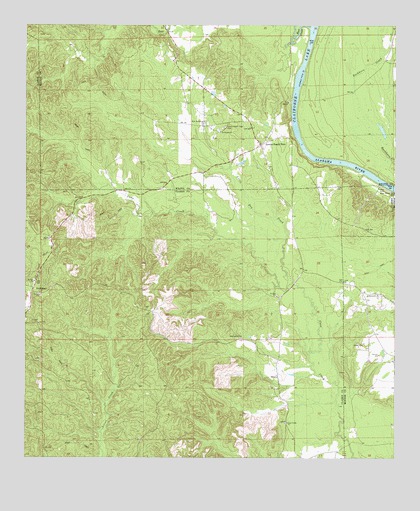
Lower Peach Tree, AL USGS Topographic Map
Click on map above to begin viewing in our Map Viewer.

This topographic map contains these locations and features:
Feature Name Type Latitude Longitude GNIS ID View Map
A O H ChurchChurchN31.8010°W87.5175°112877View Map
All Saints ChurchChurchN31.7971°W87.5058°112990View Map
Bear CreekStreamN31.8743°W87.5289°113659View Map
Botts Ferry (historical)CrossingN31.8702°W87.5283°138438View Map
Cane Creek ChurchChurchN31.7604°W87.5364°115553View Map
Cane School (historical)SchoolN31.7599°W87.5369°133592View Map
Center School (historical)SchoolN31.8496°W87.5861°138449View Map
Damon (historical)LocaleN31.7988°W87.5528°133608View Map
Henry LandingLocaleN31.8315°W87.5058°138483View Map
Jones BranchStreamN31.8715°W87.5333°138497View Map
Kennedy CemeteryCemeteryN31.7849°W87.5522°121149View Map
Kennedy LandingLocaleN31.8529°W87.5167°138500View Map
Little Dry CreekStreamN31.8010°W87.5344°152092View Map
Lower Peach TreePopulated PlaceN31.8407°W87.5453°122080View Map
Lower Peach Tree CemeteryCemeteryN31.8457°W87.5580°122081View Map
Lower Peach Tree Ferry (historical)CrossingN31.8529°W87.5350°138508View Map
Lower Peach Tree Post OfficePost OfficeN31.8407°W87.5449°167565View Map
Lower Peach Tree SchoolSchoolN31.8632°W87.5756°138506View Map
Lower Peach Tree Volunteer Fire DepartmentBuildingN31.8466°W87.5647°2691604View Map
Lower Peachtree LandingLocaleN31.8407°W87.5325°138507View Map
McClouds LandingLocaleN31.8460°W87.5350°138511View Map
Montgomery BarBarN31.8746°W87.5264°138523View Map
NettleboroPopulated PlaceN31.7990°W87.6222°156777View Map
New Mount Moriah ChurchChurchN31.8474°W87.5644°152663View Map
Ohio BarBarN31.8577°W87.5333°138541View Map
Ohio Island (historical)IslandN31.8585°W87.5333°138542View Map
Packers Bend Volunteer Fire DepartmentBuildingN31.7966°W87.5105°2691587View Map
Poe LandingLocaleN31.8682°W87.5283°138556View Map
Saint Thomas ChurchChurchN31.8443°W87.5592°126217View Map
Sakti Nakni OntalaCliffN31.8257°W87.5078°158270View Map
Webb LandingLocaleN31.8518°W87.5353°159010View Map

Note: Coordinates in the location and feature list above are referenced to NAD83 datum.


Copyright (C) 2008-2024 Ryan Niemi / Sunset Dynamics ... All Rights Reserved