TopoQuest Logo
Do you find TopoQuest useful?
Help keep TopoQuest running and adding new maps/features by donating!
Bitcoin:  19c7KJd3qBynnjoSw5npx9KScwjBe4ifkT
Litecoin:  LXs6TkuXGGXo1vDsWCkWVdjQX94eUKd6ui
Home View Maps Find Maps Find Places Resources & Links


Big Creek, Kentucky Topographic Map

USGS Map Title: Big Creek, KY
USGS Map MRC: 37083B5
DRG (GeoTIFF) Download: o37083b5.tif


Neighboring USGS Topographic Map Quads:


  Oneida, KY  
37083C6
 

  Mistletoe, KY  
37083C5
 

  Buckhorn, KY  
37083C4
 

  Barcreek, KY  
37083B6
 

  Big Creek, KY  
37083B5
 

  Hyden West, KY  
37083B4
 

  Ogle, KY  
37083A6
 

  Creekville, KY  
37083A5
 

  Hoskinston, KY  
37083A4


Map MRC Location:

N38°
W84°
N38°
W83°
H8 H7 H6 H5 H4 H3 H2 H1
G8 G7 G6 G5 G4 G3 G2 G1
F8 F7 F6 F5 F4 F3 F2 F1
E8 E7 E6 E5 E4 E3 E2 E1
D8 D7 D6 D5 D4 D3 D2 D1
C8 C7 C6 C5 C4 C3 C2 C1
B8 B7 B6 B5 B4 B3 B2 B1
A8 A7 A6 A5 A4 A3 A2 A1
N37°
W84°
N37°
W83°

Big Creek, KY USGS 1:24K Topographic Map Preview:
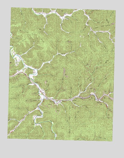
Big Creek, KY USGS Topographic Map
Click on map above to begin viewing in our Map Viewer.

This topographic map contains these locations and features:
Feature Name Type Latitude Longitude GNIS ID View Map
Aaron BranchStreamN37.1715°W83.5035°510194View Map
Barger BranchStreamN37.2439°W83.5539°510390View Map
Barger BranchStreamN37.2479°W83.5477°510391View Map
Bear BranchPopulated PlaceN37.1634°W83.5488°510440View Map
Bear BranchStreamN37.1640°W83.5482°510451View Map
Bear Branch Post OfficePost OfficeN37.1637°W83.5488°2363107View Map
Bear Branch SchoolSchoolN37.1668°W83.5421°510460View Map
Big Briar BranchStreamN37.2351°W83.5330°510631View Map
Big CreekPopulated PlaceN37.1623°W83.5688°510640View Map
Big CreekStreamN37.1668°W83.5821°510641View Map
Big Creek DivisionCivilN37.1554°W83.6231°1936876View Map
Big Creek Elementary SchoolSchoolN37.1640°W83.5155°517553View Map
Big Creek Fire and RescueBuildingN37.1582°W83.5868°2636262View Map
Big Creek Institute (historical)SchoolN37.1616°W83.5694°2543035View Map
Big Creek Post OfficePost OfficeN37.1624°W83.5700°2543036View Map
Big Creek SchoolSchoolN37.1698°W83.5841°516808View Map
Big Double CreekStreamN37.1401°W83.5874°510650View Map
Big Lick BranchStreamN37.2146°W83.5410°2543038View Map
Bobs ForkPopulated PlaceN37.1639°W83.5186°2091389View Map
Bobs ForkStreamN37.1640°W83.5182°510827View Map
Bobs Fork SchoolSchoolN37.1712°W83.5030°510828View Map
Britton BranchStreamN37.1712°W83.5882°510931View Map
BrutusPopulated PlaceN37.2473°W83.5769°510986View Map
Brutus ChurchChurchN37.2462°W83.5946°510987View Map
Brutus Post Office (historical)Post OfficeN37.2449°W83.5822°2543047View Map
Chandler BranchStreamN37.1687°W83.5235°511311View Map
Charley Fork Dry BranchStreamN37.2169°W83.5965°2543135View Map
Cold Spring BranchStreamN37.1640°W83.5482°511457View Map
Collins ForkStreamN37.2059°W83.5596°511473View Map
Couch ForkStreamN37.1687°W83.5071°511575View Map
Crane BranchStreamN37.2429°W83.5827°511618View Map
Crib BranchStreamN37.1990°W83.5782°511636View Map
Culton Post Office (historical)Post OfficeN37.1401°W83.6113°2543062View Map
Danger BranchStreamN37.2426°W83.5632°511709View Map
Daniel Boone National Forest Redbird Ranger DistrictBuildingN37.1388°W83.5901°2637448View Map
Dry BranchStreamN37.2020°W83.6113°511907View Map
Dry BranchStreamN37.2443°W83.5877°511912View Map
Elk CreekStreamN37.1545°W83.5880°512036View Map
ErilinePopulated PlaceN37.1887°W83.5930°512082View Map
Erline Post Office (historical)Post OfficeN37.1880°W83.5934°2543066View Map
Fairview SchoolSchoolN37.2456°W83.5594°512114View Map
Fish Trap BranchStreamN37.1790°W83.5944°512165View Map
Flat WoodsFlatN37.2187°W83.5869°512198View Map
Flat WoodsAreaN37.2251°W83.5991°512199View Map
Grannys BranchStreamN37.1640°W83.5730°512369View Map
Hals ForkStreamN37.1643°W83.5180°512528View Map
Head of Bullskin School (historical)SchoolN37.2339°W83.5308°2543086View Map
Hector BranchStreamN37.1943°W83.6063°512629View Map
Henry ForkStreamN37.1565°W83.5057°512658View Map
Jacks CreekPopulated PlaceN37.2070°W83.5566°512956View Map
Jacks CreekStreamN37.1912°W83.5913°512958View Map
Jacks Creek Post Office (historical)Post OfficeN37.2075°W83.5576°2543101View Map
Jacks Creek SchoolSchoolN37.2073°W83.5671°512960View Map
Left Fork Bear BranchStreamN37.1573°W83.5407°513301View Map
Left Fork Ulysses CreekStreamN37.1698°W83.5388°513330View Map
Lip BranchStreamN37.1970°W83.5835°513444View Map
Little Double CreekStreamN37.1401°W83.5919°513477View Map
Little Fish Trap BranchStreamN37.1751°W83.6041°513481View Map
Lost BranchStreamN37.1495°W83.5996°513638View Map
Lower Jacks BranchStreamN37.1868°W83.5932°513698View Map
Lucey BranchStreamN37.2453°W83.5764°2543110View Map
Lynn BranchStreamN37.2029°W83.6199°513735View Map
Martin BranchStreamN37.2426°W83.5619°513801View Map
Mouth of Hector (historical)Populated PlaceN37.1939°W83.6070°2543158View Map
New Berry SchoolSchoolN37.1881°W83.6074°514232View Map
New Hector ChurchChurchN37.1906°W83.6146°516782View Map
Newberry HillSummitN37.1684°W83.6015°2543164View Map
Otter BranchStreamN37.2498°W83.5407°514383View Map
PancoPopulated PlaceN37.2373°W83.5335°514425View Map
Panco BranchStreamN37.2431°W83.5332°514426View Map
Panco Post Office (historical)Post OfficeN37.2442°W83.5327°2543172View Map
PeabodyPopulated PlaceN37.1390°W83.5907°514465View Map
Peabody Base Radio TowerTowerN37.1298°W83.5663°517554View Map
Peabody SchoolSchoolN37.1426°W83.5927°514466View Map
Polly Marcum BranchStreamN37.1626°W83.5835°501015View Map
Red Star (historical)Populated PlaceN37.1391°W83.6156°2336185View Map
Redbird Ranger District OfficeBuildingN37.1395°W83.5907°517552View Map
Rices ForkStreamN37.1406°W83.6099°514907View Map
Right Fork Bear BranchStreamN37.1565°W83.5410°514927View Map
Roberts CemeteryCemeteryN37.1656°W83.5507°515002View Map
Sams BranchStreamN37.1500°W83.5849°2543189View Map
Sizerock Post Office (historical)Post OfficeN37.2225°W83.5052°2362771View Map
Sizerock SchoolSchoolN37.2220°W83.5044°515449View Map
Smithern ForkStreamN37.2090°W83.5507°515516View Map
Sourwood BranchStreamN37.2287°W83.5227°515537View Map
Spencers BranchStreamN37.1626°W83.5641°515585View Map
Spurlock ForkStreamN37.2068°W83.5666°515637View Map
Sugar Camp BranchStreamN37.2493°W83.5438°515785View Map
Trace BranchStreamN37.2315°W83.5288°515999View Map
Ulysses CreekStreamN37.1662°W83.5416°516095View Map
Ulysses Creek SchoolSchoolN37.1887°W83.5249°516096View Map
Wiles BranchStreamN37.2451°W83.5710°516374View Map
Wolf BranchStreamN37.2415°W83.5321°516429View Map

Note: Coordinates in the location and feature list above are referenced to NAD83 datum.


Copyright (C) 2008-2024 Ryan Niemi / Sunset Dynamics ... All Rights Reserved