TopoQuest Logo
Do you find TopoQuest useful?
Help keep TopoQuest running and adding new maps/features by donating!
Bitcoin:  19c7KJd3qBynnjoSw5npx9KScwjBe4ifkT
Litecoin:  LXs6TkuXGGXo1vDsWCkWVdjQX94eUKd6ui
Home View Maps Find Maps Find Places Resources & Links


Indian Mound, Tennessee Topographic Map

USGS Map Title: Indian Mound, TN
USGS Map MRC: 36087E6
DRG (GeoTIFF) Download: o36087e6.tif


Neighboring USGS Topographic Map Quads:


  Johnson Hollow, KY  
36087F7
 

  Roaring Spring, KY  
36087F6
 

  Herndon, KY  
36087F5
 

  Bumpus Mills, TN  
36087E7
 

  Indian Mound, TN  
36087E6
 

  Woodlawn, TN  
36087E5
 

  Dover, TN  
36087D7
 

  Cumberland City, TN  
36087D6
 

  Needmore, TN  
36087D5


Map MRC Location:

N37°
W88°
N37°
W87°
H8 H7 H6 H5 H4 H3 H2 H1
G8 G7 G6 G5 G4 G3 G2 G1
F8 F7 F6 F5 F4 F3 F2 F1
E8 E7 E6 E5 E4 E3 E2 E1
D8 D7 D6 D5 D4 D3 D2 D1
C8 C7 C6 C5 C4 C3 C2 C1
B8 B7 B6 B5 B4 B3 B2 B1
A8 A7 A6 A5 A4 A3 A2 A1
N36°
W88°
N36°
W87°

Indian Mound, TN USGS 1:24K Topographic Map Preview:
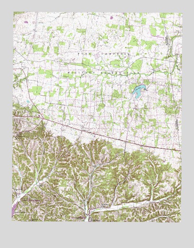
Indian Mound, TN USGS Topographic Map
Click on map above to begin viewing in our Map Viewer.

This topographic map contains these locations and features:
Feature Name Type Latitude Longitude GNIS ID View Map
Ardee (historical)Populated PlaceN36.5431°W87.6264°1308772View Map
AtkinsPopulated PlaceN36.5237°W87.7306°1647079View Map
Atkins SchoolSchoolN36.5214°W87.7295°1275968View Map
Austin CemeteryCemeteryN36.5156°W87.7172°1275998View Map
Big A SchoolSchoolN36.5509°W87.7456°1277222View Map
Buckhart HollowValleyN36.5220°W87.7305°1647081View Map
Buhler School (historical)SchoolN36.5792°W87.6670°1308799View Map
Cherry BranchStreamN36.5070°W87.6792°1280334View Map
Commissary Hollow Access PointParkN36.5092°W87.7492°1642932View Map
Commissary SchoolSchoolN36.5009°W87.7359°1281043View Map
Commissioner District 2CivilN36.5862°W87.7229°2463974View Map
Cross Creek ChurchChurchN36.5092°W87.6825°1306192View Map
Dicks Fork CreekStreamN36.5020°W87.6953°1282451View Map
Elk Fork CreekStreamN36.5942°W87.6297°1283637View Map
Gillum HollowValleyN36.5038°W87.6928°1647086View Map
Givins CemeteryCemeteryN36.5334°W87.6889°1285465View Map
Green HollowValleyN36.5379°W87.6921°1308858View Map
Greer HollowValleyN36.5282°W87.6921°1308859View Map
Guinn School (historical)SchoolN36.6245°W87.7417°1308861View Map
Hall CemeteryCemeteryN36.5403°W87.7281°1286583View Map
Indian MoundPopulated PlaceN36.5009°W87.6936°1306608View Map
Indian Mound Post OfficePost OfficeN36.5021°W87.6926°1649769View Map
Indian Mound SchoolSchoolN36.5075°W87.6934°1308876View Map
Joiner CemeteryCemeteryN36.5528°W87.7442°1289676View Map
Keats HollowValleyN36.5328°W87.6890°1308880View Map
Kyle Lake DamDamN36.5810°W87.6579°1307210View Map
Lake KyleReservoirN36.5787°W87.6569°1290425View Map
LegatePopulated PlaceN36.5545°W87.6986°1290998View Map
Legate School (historical)SchoolN36.5542°W87.6986°1325375View Map
Lewis BranchStreamN36.5231°W87.7320°1291061View Map
Lewis HollowValleyN36.5293°W87.7309°1308888View Map
Lineberry CemeteryCemeteryN36.5548°W87.7145°1291335View Map
Little Cub CreekStreamN36.5228°W87.7322°1308890View Map
McNichols HollowValleyN36.5135°W87.6473°1308900View Map
Meadow School (historical)SchoolN36.6103°W87.6545°1308901View Map
Mont Zion Church (historical)SchoolN36.6237°W87.7106°1308913View Map
North Fork North Cross CreekStreamN36.5145°W87.6370°1308926View Map
North Stewart Elementary SchoolSchoolN36.5631°W87.7303°1308927View Map
O K School (historical)SchoolN36.6031°W87.7078°1308928View Map
Parker Town (historical)Populated PlaceN36.6000°W87.6978°1308933View Map
Piney Fork BranchStreamN36.5884°W87.6792°1308940View Map
Pool FourReservoirN36.5017°W87.6550°1302645View Map
Pool Four DamDamN36.5017°W87.6550°1302646View Map
Red TopPopulated PlaceN36.5481°W87.6659°1308949View Map
Rorie HollowValleyN36.5033°W87.6949°1647102View Map
Rose Valley ChurchChurchN36.5192°W87.7475°1306970View Map
Seay SpringSpringN36.5128°W87.6964°1649784View Map
Shepherd HollowValleyN36.5234°W87.7301°1647103View Map
Smith CemeteryCemeteryN36.5489°W87.6456°1647105View Map
Smith HollowValleyN36.5364°W87.7169°1308975View Map
Smiths Grove School (historical)SchoolN36.5617°W87.6497°1308976View Map
South Fork North Cross CreekStreamN36.5145°W87.6370°1308978View Map
Stampers Chapel (historical)ChurchN36.5709°W87.6625°1308979View Map
Stewart County Volunteer Fire Service Station 10 Indian MoundBuildingN36.5015°W87.6927°2654286View Map
Stewart County Volunteer Fire Service Station 2 Red TopBuildingN36.5388°W87.6686°2654202View Map
Terrell HollowValleyN36.5343°W87.6867°1308991View Map
Weakley Horn HollowValleyN36.5506°W87.7299°1309013View Map
Wilson HollowValleyN36.5291°W87.6630°1309020View Map
Wyatts ChapelPopulated PlaceN36.5512°W87.7461°1647112View Map
Wyatts ChurchChurchN36.5506°W87.7472°1304692View Map

Note: Coordinates in the location and feature list above are referenced to NAD83 datum.


Copyright (C) 2008-2025 Ryan Niemi / Sunset Dynamics ... All Rights Reserved