TopoQuest Logo
Do you find TopoQuest useful?
Help keep TopoQuest running and adding new maps/features by donating!
Bitcoin:  19c7KJd3qBynnjoSw5npx9KScwjBe4ifkT
Litecoin:  LXs6TkuXGGXo1vDsWCkWVdjQX94eUKd6ui
Home View Maps Find Maps Find Places Resources & Links


Bumpus Mills, Tennessee Topographic Map

USGS Map Title: Bumpus Mills, TN
USGS Map MRC: 36087E7
DRG (GeoTIFF) Download: o36087e7.tif


Neighboring USGS Topographic Map Quads:


  Linton, KY  
36087F8
 

  Johnson Hollow, KY  
36087F7
 

  Roaring Spring, KY  
36087F6
 

  Tharpe, TN  
36087E8
 

  Bumpus Mills, TN  
36087E7
 

  Indian Mound, TN  
36087E6
 

  Standing Rock, TN  
36087D8
 

  Dover, TN  
36087D7
 

  Cumberland City, TN  
36087D6


Map MRC Location:

N37°
W88°
N37°
W87°
H8 H7 H6 H5 H4 H3 H2 H1
G8 G7 G6 G5 G4 G3 G2 G1
F8 F7 F6 F5 F4 F3 F2 F1
E8 E7 E6 E5 E4 E3 E2 E1
D8 D7 D6 D5 D4 D3 D2 D1
C8 C7 C6 C5 C4 C3 C2 C1
B8 B7 B6 B5 B4 B3 B2 B1
A8 A7 A6 A5 A4 A3 A2 A1
N36°
W88°
N36°
W87°

Bumpus Mills, TN USGS 1:24K Topographic Map Preview:
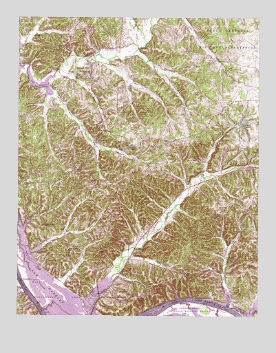
Bumpus Mills, TN USGS Topographic Map
Click on map above to begin viewing in our Map Viewer.

This topographic map contains these locations and features:
Feature Name Type Latitude Longitude GNIS ID View Map
Athens School (historical)SchoolN36.6198°W87.7834°1308774View Map
Bellwood BranchStreamN36.5039°W87.7653°1305098View Map
Bellwood Furnace (historical)LocaleN36.5103°W87.7645°1308780View Map
Bellwood HollowValleyN36.5053°W87.7652°1647080View Map
Bellwood Landing (historical)LocaleN36.5034°W87.7650°1642923View Map
Bellwood SchoolSchoolN36.5245°W87.7667°1276975View Map
Bethel ChurchChurchN36.5606°W87.8450°1305153View Map
Big RockPopulated PlaceN36.5806°W87.7600°1305229View Map
Big Rock Post OfficePost OfficeN36.5813°W87.7595°1649744View Map
Big Rock SchoolSchoolN36.5748°W87.7592°1308783View Map
Biggs BranchStreamN36.6092°W87.8159°1277449View Map
Biggs HollowValleyN36.6103°W87.8136°1308782View Map
Blue Creek Recreation AreaParkN36.5256°W87.8661°1642926View Map
Bumpus MillsPopulated PlaceN36.6048°W87.8375°1278984View Map
Bumpus Mills Post OfficePost OfficeN36.6003°W87.8380°1649750View Map
Bumpus Mills SchoolSchoolN36.6053°W87.8339°1308802View Map
Camp Antioch School (historical)SchoolN36.5845°W87.8686°1308807View Map
Carney Landing (historical)LocaleN36.5076°W87.7850°1642930View Map
Center Point SchoolSchoolN36.5278°W87.8484°1280145View Map
Chestnut GrovePopulated PlaceN36.5576°W87.8689°1647082View Map
Chestnut Grove SchoolSchoolN36.5553°W87.8717°1280392View Map
Church of the NazareneChurchN36.5737°W87.8097°1308813View Map
Commissioner District 3CivilN36.6037°W87.8529°2464198View Map
Crow CemeteryCemeteryN36.6120°W87.8267°1281739View Map
Cub CreekStreamN36.5031°W87.7639°1269509View Map
Cub Creek CoveBayN36.5056°W87.7506°1647085View Map
Dover IslandIslandN36.5026°W87.8014°1282755View Map
Dryers Creek Recreational AreaParkN36.5014°W87.8334°1642937View Map
Ellis School (historical)SchoolN36.6245°W87.8139°1308840View Map
Ezell CemeteryCemeteryN36.6229°W87.8211°1283952View Map
George Wallace CemeteryCemeteryN36.5964°W87.8581°1273681View Map
Glasgow Landing (historical)LocaleN36.5062°W87.7864°1642939View Map
Green Hill CemeteryCemeteryN36.6023°W87.8456°1286096View Map
Hargis HollowValleyN36.6187°W87.8651°1308864View Map
Harrison RidgeRidgeN36.5578°W87.8100°1647088View Map
Hayes Fork CreekStreamN36.5956°W87.8606°1287220View Map
Hayes Fork SchoolSchoolN36.5723°W87.8342°1287221View Map
Heflin CemeteryCemeteryN36.5153°W87.7917°1287328View Map
Indian BranchStreamN36.5928°W87.8595°1308875View Map
Indian Mound-Bumpus Mills Division (historical)CensusN36.5398°W87.7692°1648964View Map
Jackson CemeteryCemeteryN36.5564°W87.8711°1289212View Map
Joiner HollowValleyN36.5545°W87.7875°1647091View Map
Keatts CemeteryCemeteryN36.5423°W87.7731°1289926View Map
Keel HollowValleyN36.5246°W87.8161°1647093View Map
Lees ChapelChurchN36.5387°W87.8261°1308887View Map
Line Wallace CemeteryCemeteryN36.5733°W87.8348°2776598View Map
Lottie Wallace CemeteryCemeteryN36.5889°W87.8497°1273680View Map
Melton SpringSpringN36.5707°W87.8246°1647096View Map
Morgan BranchStreamN36.6023°W87.8542°1294354View Map
Morgan CemeteryCemeteryN36.5996°W87.8421°1294363View Map
Morris CreekStreamN36.5584°W87.7811°1647098View Map
Mossy Run CreekStreamN36.5378°W87.8747°1294519View Map
Mount Olivet ChurchChurchN36.6017°W87.8397°1294730View Map
Mount Storm Church (historical)ChurchN36.6228°W87.7859°1308911View Map
Mud CreekStreamN36.5314°W87.8736°1308915View Map
Nelums CemeteryCemeteryN36.5109°W87.8167°1295392View Map
New HavenPopulated PlaceN36.5078°W87.8159°1647099View Map
New Haven SchoolSchoolN36.5073°W87.8181°1295491View Map
New Haven Union ChurchChurchN36.5073°W87.8122°1295492View Map
Oak Hill School (historical)SchoolN36.6220°W87.8720°1308929View Map
Phillips Church (historical)ChurchN36.5559°W87.7817°1308937View Map
Pleasant Hill ChurchChurchN36.5373°W87.8609°1297889View Map
Pool TwoReservoirN36.5002°W87.7935°1302644View Map
Pool Two DamDamN36.5001°W87.7984°1302643View Map
Ralls CemeteryCemeteryN36.5050°W87.8703°1298861View Map
Robinson HillSummitN36.5345°W87.8261°1647101View Map
Saline Furnace (historical)LocaleN36.6181°W87.8661°1308963View Map
Scott BranchStreamN36.6120°W87.8134°1300927View Map
Sextons Landing (historical)LocaleN36.5062°W87.7753°1642960View Map
Sharper BranchStreamN36.5714°W87.8347°1308970View Map
Smith CemeteryCemeteryN36.5881°W87.7572°1270652View Map
Spring BranchStreamN36.5426°W87.7972°1647106View Map
Stewart CountyCivilN36.5011°W87.8385°1639792View Map
Stewart County Volunteer Fire Service Station 1 Big RockBuildingN36.5815°W87.7595°2653739View Map
Stewart County Volunteer Fire Service Station 3 New HavenBuildingN36.5083°W87.8114°2654201View Map
Stewart County Volunteer Fire Service Station 7 Bumpus MillsBuildingN36.5992°W87.8370°2653837View Map
Sugar Camp HollowValleyN36.5137°W87.8517°1308986View Map
Taylor BranchStreamN36.5981°W87.8192°1304016View Map
Taylor CemeteryCemeteryN36.5259°W87.8650°1272219View Map
Taylor CemeteryCemeteryN36.5570°W87.8525°1272221View Map
Taylors ChapelChurchN36.5712°W87.8172°1304028View Map
Taylors Chapel CemeteryCemeteryN36.5714°W87.8172°1325379View Map
Wagners Landing (historical)LocaleN36.5098°W87.8692°1642969View Map
Walker RidgeRidgeN36.6075°W87.7875°1647107View Map
Wall CreekStreamN36.6067°W87.8356°1304345View Map
Wall HollowValleyN36.5978°W87.8172°1647108View Map
Wallace RidgeRidgeN36.5526°W87.8339°1309010View Map
Wiley Spring BranchStreamN36.5095°W87.8709°1652594View Map
Williams CemeteryCemeteryN36.5753°W87.8281°1274685View Map
Wyatt HollowValleyN36.6002°W87.7986°1647111View Map
Yarborough HollowValleyN36.5407°W87.7946°1647113View Map

Note: Coordinates in the location and feature list above are referenced to NAD83 datum.


Copyright (C) 2008-2024 Ryan Niemi / Sunset Dynamics ... All Rights Reserved