TopoQuest Logo
Do you find TopoQuest useful?
Help keep TopoQuest running and adding new maps/features by donating!
Bitcoin:  19c7KJd3qBynnjoSw5npx9KScwjBe4ifkT
Litecoin:  LXs6TkuXGGXo1vDsWCkWVdjQX94eUKd6ui
Home View Maps Find Maps Find Places Resources & Links


Baker Springs, Arkansas Topographic Map

USGS Map Title: Baker Springs, AR
USGS Map MRC: 34094C2
DRG (GeoTIFF) Download: o34094c2.tif


Neighboring USGS Topographic Map Quads:


  Vandervoort, AR  
34094D3
 

  Eagle Mountain, AR  
34094D2
 

  Nichols Mountain, AR  
34094D1
 

  Wickes, AR  
34094C3
 

  Baker Springs, AR  
34094C2
 

  Umpire, AR  
34094C1
 

  Gillham, AR  
34094B3
 

  Gillham Dam, AR  
34094B2
 

  Dierks Dam, AR  
34094B1


Map MRC Location:

N35°
W95°
N35°
W94°
H8 H7 H6 H5 H4 H3 H2 H1
G8 G7 G6 G5 G4 G3 G2 G1
F8 F7 F6 F5 F4 F3 F2 F1
E8 E7 E6 E5 E4 E3 E2 E1
D8 D7 D6 D5 D4 D3 D2 D1
C8 C7 C6 C5 C4 C3 C2 C1
B8 B7 B6 B5 B4 B3 B2 B1
A8 A7 A6 A5 A4 A3 A2 A1
N34°
W95°
N34°
W94°

Baker Springs, AR USGS 1:24K Topographic Map Preview:
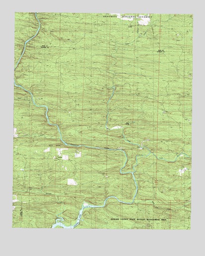
Baker Springs, AR USGS Topographic Map
Click on map above to begin viewing in our Map Viewer.

This topographic map contains these locations and features:
Feature Name Type Latitude Longitude GNIS ID View Map
Baker CreekStreamN34.2943°W94.1544°76224View Map
Baker FordCrossingN34.2959°W94.1777°62526View Map
Baker SpringsPopulated PlaceN34.3126°W94.1677°76225View Map
Center CemeteryCemeteryN34.3590°W94.1358°63170View Map
Center ChurchChurchN34.3632°W94.1358°71097View Map
Center School (historical)SchoolN34.3637°W94.1363°81946View Map
Church FordCrossingN34.2704°W94.1641°62557View Map
Cow CreekStreamN34.3026°W94.2171°71257View Map
Cow Creek FordCrossingN34.3071°W94.2185°62564View Map
Devils HollowValleyN34.2987°W94.2146°71379View Map
DuckettPopulated PlaceN34.2904°W94.2199°62575View Map
Duckett CemeteryCemeteryN34.2976°W94.2485°71464View Map
Duckett FordPopulated PlaceN34.2632°W94.1935°71465View Map
Faulkner BranchStreamN34.3626°W94.1627°71601View Map
Happy Hill School (historical)SchoolN34.3684°W94.1941°81933View Map
Harris CreekStreamN34.2829°W94.1669°71922View Map
HartleyPopulated PlaceN34.3684°W94.1708°71926View Map
Mineral Branch School (historical)SchoolN34.2512°W94.2310°62619View Map
Opossum CreekStreamN34.2534°W94.2191°72956View Map
Planner FordCrossingN34.3543°W94.2430°62654View Map
Pryor CreekStreamN34.3234°W94.2366°73212View Map
Pryor FordCrossingN34.3223°W94.2360°62657View Map
Pryor Ridge (historical)Populated PlaceN34.3346°W94.2169°62658View Map
Pryor Ridge School (historical)SchoolN34.3284°W94.2133°62659View Map
Rankin FordCrossingN34.2565°W94.2030°62661View Map
Scrougeout School (historical)SchoolN34.2798°W94.2077°62677View Map
Shiloh School (historical)SchoolN34.3151°W94.1496°62680View Map
Township of Baker (historical)CivilN34.3251°W94.1585°66237View Map
Township of DuckettCivilN34.2770°W94.2232°66681View Map
Township of UmpireCivilN34.2807°W94.1300°66691View Map
White Oak CreekStreamN34.2659°W94.1666°74118View Map

Note: Coordinates in the location and feature list above are referenced to NAD83 datum.


Copyright (C) 2008-2025 Ryan Niemi / Sunset Dynamics ... All Rights Reserved