TopoQuest Logo
Do you find TopoQuest useful?
Help keep TopoQuest running and adding new maps/features by donating!
Bitcoin:  19c7KJd3qBynnjoSw5npx9KScwjBe4ifkT
Litecoin:  LXs6TkuXGGXo1vDsWCkWVdjQX94eUKd6ui
Home View Maps Find Maps Find Places Resources & Links


Table Mountain, New Mexico Topographic Map

USGS Map Title: Table Mountain, NM
USGS Map MRC: 34107D5
DRG (GeoTIFF) Download: o34107d5.tif


Neighboring USGS Topographic Map Quads:


  Wiley Mesa, NM  
34107E6
 

  Pueblo Viejo Mesa, NM  
34107E5
 

  Field Ranch, NM  
34107E4
 

  D Cross Mountain, NM  
34107D6
 

  Table Mountain, NM  
34107D5
 

  Puertecito, NM  
34107D4
 

  Dog Springs, NM  
34107C6
 

  Indian Mesa, NM  
34107C5
 

  Indian Spring Canyon, NM  
34107C4


Map MRC Location:

N35°
W108°
N35°
W107°
H8 H7 H6 H5 H4 H3 H2 H1
G8 G7 G6 G5 G4 G3 G2 G1
F8 F7 F6 F5 F4 F3 F2 F1
E8 E7 E6 E5 E4 E3 E2 E1
D8 D7 D6 D5 D4 D3 D2 D1
C8 C7 C6 C5 C4 C3 C2 C1
B8 B7 B6 B5 B4 B3 B2 B1
A8 A7 A6 A5 A4 A3 A2 A1
N34°
W108°
N34°
W107°

Table Mountain, NM USGS 1:24K Topographic Map Preview:
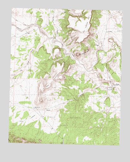
Table Mountain, NM USGS Topographic Map
Click on map above to begin viewing in our Map Viewer.

This topographic map contains these locations and features:
Feature Name Type Latitude Longitude GNIS ID View Map
26-7-1 Water WellWellN34.4189°W107.5120°925839View Map
27-1-1 Water WellWellN34.4337°W107.5314°925833View Map
27-1-1A Water WellWellN34.4337°W107.5314°925801View Map
27-12-1 Water WellWellN34.4117°W107.5167°925837View Map
27-13-9 Water WellWellN34.4045°W107.5178°925544View Map
A-3 Water WellWellN34.4839°W107.5206°925561View Map
A-7 Water WellWellN34.4673°W107.5256°925826View Map
AlamoPopulated PlaceN34.4209°W107.5109°1852622View Map
Alamo Census Designated PlaceCensusN34.4184°W107.5125°2407708View Map
Alamo ChapterCivilN34.4108°W107.5222°2419296View Map
Alamo Day SchoolSchoolN34.4312°W107.5089°903046View Map
Alamo MissionChurchN34.4281°W107.5137°903047View Map
Alamocita CreekStreamN34.4839°W107.6020°903052View Map
Apashito WellWellN34.3981°W107.5195°925543View Map
Benevites TankReservoirN34.4084°W107.5965°903747View Map
Blue WindmillLocaleN34.4376°W107.6231°903956View Map
Blue Windmill Water WellWellN34.4376°W107.6231°925554View Map
Bugger WellWellN34.3951°W107.6092°904167View Map
Casimero SpringSpringN34.3753°W107.5634°904825View Map
Dog Springs CanyonValleyN34.4734°W107.5837°905804View Map
Gallegos CreekStreamN34.4709°W107.5731°906442View Map
Headquaters Water WellWellN34.4726°W107.6073°925827View Map
Jaramillo CanyonValleyN34.4337°W107.5170°907315View Map
KABR-AM (Alamo Community)TowerN34.4170°W107.5017°938570View Map
Martin WellWellN34.3767°W107.5600°925670View Map
Number 10 Water WellWellN34.4967°W107.5659°925563View Map
PM-2 Water WellWellN34.4112°W107.5062°925836View Map
Red Lake RanchLocaleN34.4773°W107.6067°910070View Map
Table MountainSummitN34.4142°W107.5895°911524View Map
Tres Hermanos PeaksSummitN34.4589°W107.5484°911805View Map
Tres Hermanos RanchLocaleN34.4670°W107.5262°911806View Map
UP-1 Water WellWellN34.4317°W107.5095°925832View Map
UP-2 Water WellWellN34.4312°W107.5106°925831View Map
Water Well BWellN34.4726°W107.6073°925828View Map
Windmill Number 10LocaleN34.4970°W107.5662°912458View Map

Note: Coordinates in the location and feature list above are referenced to NAD83 datum.


Copyright (C) 2008-2025 Ryan Niemi / Sunset Dynamics ... All Rights Reserved