TopoQuest Logo
Do you find TopoQuest useful?
Help keep TopoQuest running and adding new maps/features by donating!
Bitcoin:  19c7KJd3qBynnjoSw5npx9KScwjBe4ifkT
Litecoin:  LXs6TkuXGGXo1vDsWCkWVdjQX94eUKd6ui
Home View Maps Find Maps Find Places Resources & Links


Iron Mountain, South Dakota Topographic Map

USGS Map Title: Iron Mountain, SD
USGS Map MRC: 43103G4
DRG (GeoTIFF) Download: o43103g4.tif


Neighboring USGS Topographic Map Quads:


  Hill City, SD  
43103H5
 

  Mount Rushmore, SD  
43103H4
 

  Rockerville, SD  
43103H3
 

  Custer, SD  
43103G5
 

  Iron Mountain, SD  
43103G4
 

  Hayward, SD  
43103G3
 

  Cicero Peak, SD  
43103F5
 

  Mount Coolidge, SD  
43103F4
 

  Butcher Hill, SD  
43103F3


Map MRC Location:

N44°
W104°
N44°
W103°
H8 H7 H6 H5 H4 H3 H2 H1
G8 G7 G6 G5 G4 G3 G2 G1
F8 F7 F6 F5 F4 F3 F2 F1
E8 E7 E6 E5 E4 E3 E2 E1
D8 D7 D6 D5 D4 D3 D2 D1
C8 C7 C6 C5 C4 C3 C2 C1
B8 B7 B6 B5 B4 B3 B2 B1
A8 A7 A6 A5 A4 A3 A2 A1
N43°
W104°
N43°
W103°

Iron Mountain, SD USGS 1:24K Topographic Map Preview:
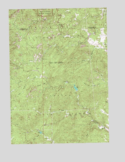
Iron Mountain, SD USGS Topographic Map
Click on map above to begin viewing in our Map Viewer.

This topographic map contains these locations and features:
Feature Name Type Latitude Longitude GNIS ID View Map
Badger Clark CreekStreamN43.7786°W103.4027°1261977View Map
Beryl Feldspar MineMineN43.8542°W103.3766°1265027View Map
Big Chief MineMineN43.8650°W103.3819°1265023View Map
Big Smoke MineMineN43.8583°W103.3782°1264848View Map
Bismuth (historical)LocaleN43.8500°W103.3980°1264164View Map
Black Elk WildernessReserveN43.8577°W103.4931°1263018View Map
Black Hills PlayhouseLocaleN43.8067°W103.4280°1261285View Map
Blackberry TrailTrailN43.8633°W103.4716°1263133View Map
C.C. Gideon TunnelTunnelN43.8620°W103.4377°2772088View Map
Camp Galena (historical)LocaleN43.7750°W103.3963°1264619View Map
Camp Ivanhoe (historical)LocaleN43.7933°W103.4152°1264637View Map
Camp RemingtonLocaleN43.8283°W103.4582°1261402View Map
Center LakeReservoirN43.8009°W103.4168°1261432View Map
Center Lake CampgroundsLocaleN43.8117°W103.4210°1263124View Map
Center Lake DamDamN43.8033°W103.4188°1262768View Map
Champion MineMineN43.8739°W103.4082°1265024View Map
Clark ParkFlatN43.7786°W103.3821°1261450View Map
Coolidge InnLocaleN43.7655°W103.3888°1263127View Map
Custer State Park Fire DepartmentBuildingN43.7795°W103.4293°2580819View Map
Custer State Park HeadquartersLocaleN43.7708°W103.3960°1261523View Map
Cuyahogo MineMineN43.8505°W103.4244°1261526View Map
Dike MineMineN43.8619°W103.4127°1265591View Map
Doane Robinson TunnelTunnelN43.8682°W103.4348°2772089View Map
Eclipse Group MineMineN43.8653°W103.3952°1265015View Map
Eureka MineMineN43.8694°W103.3894°1265022View Map
Fern Cliff Prospect MineMineN43.8528°W103.3799°1265025View Map
Formosa MineMineN43.8417°W103.4732°1265014View Map
Glendale (historical)LocaleN43.8736°W103.3935°1264592View Map
Glendale MineMineN43.8686°W103.3757°1264847View Map
Greyhound GulchValleyN43.8750°W103.3844°1261748View Map
Grizzly Bear FallsFallsN43.8636°W103.4635°1261754View Map
Grizzly Bear Picnic GroundLocaleN43.8686°W103.4396°1263129View Map
Grizzly Creek TrailTrailN43.8572°W103.4880°1263015View Map
Hugo MineMineN43.8711°W103.4255°1261852View Map
Iron Creek Horse CampLocaleN43.8297°W103.4710°1263128View Map
Iron Creek Summer Home GroupLocaleN43.8369°W103.4321°1262977View Map
Iron Creek TrailTrailN43.8433°W103.4124°1263130View Map
Iron Creek TunnelTunnelN43.8202°W103.4908°2772084View Map
Iron MountainSummitN43.8586°W103.4335°1261874View Map
Iron Mountain Picnic AreaLocaleN43.8553°W103.4382°1263136View Map
Iron Mountain TrailTrailN43.8405°W103.4402°1263132View Map
Josie MineMineN43.8361°W103.3860°1265017View Map
Jumbo Lode MineMineN43.8378°W103.3899°1265016View Map
King Lithia Prospect MineMineN43.8694°W103.3963°1265019View Map
Lakota DamDamN43.8500°W103.3971°1262873View Map
Lakota LakeReservoirN43.8498°W103.3979°1262945View Map
Legion LakeReservoirN43.7604°W103.4627°1261943View Map
Legion Lake DamDamN43.8033°W103.4188°1262767View Map
Maryland Lode MineMineN43.8289°W103.4630°1265590View Map
New England MineMineN43.8514°W103.3921°1265018View Map
Norbeck DrawValleyN43.8057°W103.4525°1262132View Map
Norbeck Memorial OverlookLocaleN43.8572°W103.4346°1263134View Map
Norbeck Memorial Overlook Recreation SiteLocaleN43.8542°W103.4049°1263131View Map
Norbeck TrailTrailN43.8278°W103.4710°1263016View Map
Norbeck Wildlife PreserveParkN43.8472°W103.4805°1267041View Map
North Fork Bear GulchValleyN43.8052°W103.3781°1262142View Map
Otlershagen Prospect MineMineN43.8717°W103.3791°1264883View Map
Pink Elephant Beryl Prospect MineMineN43.8717°W103.3963°1265020View Map
Potato GulchValleyN43.8252°W103.4114°1262232View Map
Put MineMineN43.8542°W103.3788°1265026View Map
Queen Claim MineMineN43.8694°W103.3824°1265021View Map
Scovel Johnson TunnelTunnelN43.8599°W103.4313°2772087View Map
Sheep DrawValleyN43.7587°W103.4600°1262395View Map
Soda Spar MineMineN43.8583°W103.3816°1265592View Map
South Fork Bear GulchValleyN43.8049°W103.3782°1262457View Map
SpokanePopulated PlaceN43.8414°W103.3799°1262481View Map
Spokane MineMineN43.8400°W103.3771°1262483View Map
State Game LodgePopulated PlaceN43.7711°W103.3838°1264614View Map
State Park SchoolSchoolN43.7642°W103.3832°1262508View Map
Toll Gate CreekStreamN43.8469°W103.4024°1262596View Map
Woodpecker RidgeRidgeN43.8330°W103.4182°1263125View Map
Yamboya (historical)LocaleN43.7778°W103.4441°1264163View Map

Note: Coordinates in the location and feature list above are referenced to NAD83 datum.


Copyright (C) 2008-2024 Ryan Niemi / Sunset Dynamics ... All Rights Reserved