TopoQuest Logo
Do you find TopoQuest useful?
Help keep TopoQuest running and adding new maps/features by donating!
Bitcoin:  19c7KJd3qBynnjoSw5npx9KScwjBe4ifkT
Litecoin:  LXs6TkuXGGXo1vDsWCkWVdjQX94eUKd6ui
Home View Maps Find Maps Find Places Resources & Links


Jackson, North Carolina Topographic Map

USGS Map Title: Jackson, NC
USGS Map MRC: 36077D4
DRG (GeoTIFF) Download: o36077d4.tif


Neighboring USGS Topographic Map Quads:


  Skippers, VA  
36077E5
 

  Claresville, VA  
36077E4
 

  Margarettsville, NC  
36077E3
 

  Weldon, NC  
36077D5
 

  Jackson, NC  
36077D4
 

  Galatia, NC  
36077D3
 

  Halifax, NC  
36077C5
 

  Boones Crossroads, NC  
36077C4
 

  Rich Square, NC  
36077C3


Map MRC Location:

N37°
W78°
N37°
W77°
H8 H7 H6 H5 H4 H3 H2 H1
G8 G7 G6 G5 G4 G3 G2 G1
F8 F7 F6 F5 F4 F3 F2 F1
E8 E7 E6 E5 E4 E3 E2 E1
D8 D7 D6 D5 D4 D3 D2 D1
C8 C7 C6 C5 C4 C3 C2 C1
B8 B7 B6 B5 B4 B3 B2 B1
A8 A7 A6 A5 A4 A3 A2 A1
N36°
W78°
N36°
W77°

Jackson, NC USGS 1:24K Topographic Map Preview:
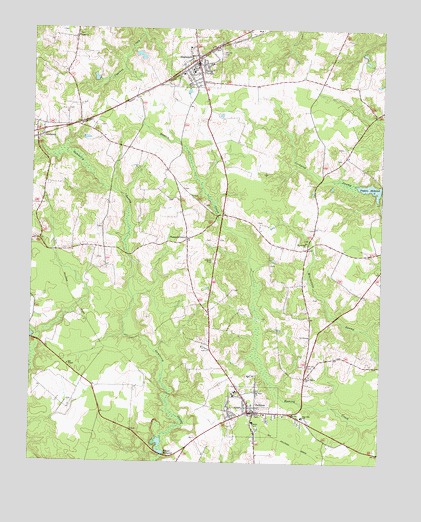
Jackson, NC USGS Topographic Map
Click on map above to begin viewing in our Map Viewer.

This topographic map contains these locations and features:
Feature Name Type Latitude Longitude GNIS ID View Map
Bethel ChurchChurchN36.4979°W77.4841°981176View Map
Boones Mill Pond DamDamN36.3779°W77.4528°1000565View Map
Boones MillpondReservoirN36.3781°W77.4526°981742View Map
GumberryPopulated PlaceN36.4704°W77.4958°1020580View Map
Gumberry SwampStreamN36.4668°W77.4997°986256View Map
Hill ChapelChurchN36.4029°W77.4864°986796View Map
JacksonPopulated PlaceN36.3896°W77.4214°1020920View Map
Jackson Post OfficePost OfficeN36.3902°W77.4185°2774175View Map
Jackson Rescue SquadBuildingN36.3902°W77.4220°2720517View Map
Jackson Volunteer Fire DepartmentBuildingN36.3893°W77.4193°2638773View Map
Jackson-Eastside Elementary SchoolSchoolN36.3882°W77.4022°1024822View Map
Mount Carmel ChurchChurchN36.4388°W77.4016°990367View Map
Mount Hope ChurchChurchN36.3960°W77.4186°990419View Map
Northampton CountyCivilN36.4177°W77.3968°1008575View Map
Northampton County Ambulance ServiceBuildingN36.4094°W77.4366°2720594View Map
Northampton County Sheriff's OfficeBuildingN36.3895°W77.4198°2130966View Map
Phillips CemeteryCemeteryN36.4932°W77.4333°992143View Map
Piney Grove ChurchChurchN36.4002°W77.3997°992366View Map
Pleasant GrovePopulated PlaceN36.4393°W77.4444°1022002View Map
SeaboardPopulated PlaceN36.4902°W77.4414°994451View Map
Seaboard Fire DepartmentBuildingN36.4900°W77.4418°2638514View Map
Seaboard Police DepartmentBuildingN36.4898°W77.4413°2130936View Map
Seaboard Post OfficePost OfficeN36.4902°W77.4409°2773912View Map
Seaboard-Coates Elementary SchoolSchoolN36.4877°W77.4433°1024816View Map
Taylors MillpondReservoirN36.4543°W77.3787°995904View Map
Town of JacksonCivilN36.3901°W77.4193°2405900View Map
Town of SeaboardCivilN36.4907°W77.4420°2407302View Map
Township of JacksonCivilN36.3858°W77.4300°1026998View Map
Township of SeaboardCivilN36.4869°W77.4429°1027004View Map

Note: Coordinates in the location and feature list above are referenced to NAD83 datum.


Copyright (C) 2008-2025 Ryan Niemi / Sunset Dynamics ... All Rights Reserved