TopoQuest Logo
Do you find TopoQuest useful?
Help keep TopoQuest running and adding new maps/features by donating!
Bitcoin:  19c7KJd3qBynnjoSw5npx9KScwjBe4ifkT
Litecoin:  LXs6TkuXGGXo1vDsWCkWVdjQX94eUKd6ui
Home View Maps Find Maps Find Places Resources & Links


Skippers, Virginia Topographic Map

USGS Map Title: Skippers, VA
USGS Map MRC: 36077E5
DRG (GeoTIFF) Download: o36077e5.tif


Neighboring USGS Topographic Map Quads:


  Ante, VA  
36077F6
 

  Emporia, VA  
36077F5
 

  Adams Grove, VA  
36077F4
 

  Barley, VA  
36077E6
 

  Skippers, VA  
36077E5
 

  Claresville, VA  
36077E4
 

  Roanoke Rapids, NC  
36077D6
 

  Weldon, NC  
36077D5
 

  Jackson, NC  
36077D4


Map MRC Location:

N37°
W78°
N37°
W77°
H8 H7 H6 H5 H4 H3 H2 H1
G8 G7 G6 G5 G4 G3 G2 G1
F8 F7 F6 F5 F4 F3 F2 F1
E8 E7 E6 E5 E4 E3 E2 E1
D8 D7 D6 D5 D4 D3 D2 D1
C8 C7 C6 C5 C4 C3 C2 C1
B8 B7 B6 B5 B4 B3 B2 B1
A8 A7 A6 A5 A4 A3 A2 A1
N36°
W78°
N36°
W77°

Skippers, VA USGS 1:24K Topographic Map Preview:
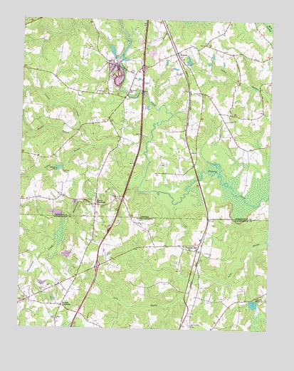
Skippers, VA USGS Topographic Map
Click on map above to begin viewing in our Map Viewer.

This topographic map contains these locations and features:
Feature Name Type Latitude Longitude GNIS ID View Map
Antioch ChurchChurchN36.5843°W77.5197°1462491View Map
Beaverpond CreekStreamN36.5574°W77.5658°980871View Map
Brewers CrossroadsPopulated PlaceN36.5090°W77.6030°981855View Map
Cattail CreekStreamN36.5638°W77.5614°1464560View Map
Cattail Creek CampgroundLocaleN36.5732°W77.5808°1500966View Map
Collier BranchStreamN36.5738°W77.5866°1465114View Map
Corinth ChurchChurchN36.5957°W77.5353°1465250View Map
Corwells MillpondReservoirN36.5118°W77.5061°983587View Map
DahliaPopulated PlaceN36.5699°W77.5389°1499319View Map
Diamond Grove Baptist ChurchChurchN36.5952°W77.5836°1465756View Map
Faithful Band ChurchChurchN36.5013°W77.5375°984969View Map
Gaston Fire Department SubstationBuildingN36.5174°W77.6041°2639359View Map
Hitchcock Mill (historical)LocaleN36.6065°W77.5783°1500993View Map
Hitchcock QuarryMineN36.6065°W77.5772°1500994View Map
Interchange 4CrossingN36.6057°W77.5641°1500996View Map
Jetts School (historical)SchoolN36.5513°W77.6241°1501001View Map
Lebanon ChurchChurchN36.5040°W77.6061°988272View Map
Massie BranchStreamN36.5732°W77.5919°1470177View Map
Mitchells MillPopulated PlaceN36.5954°W77.5714°1499752View Map
Pleasant HillPopulated PlaceN36.5321°W77.5355°992510View Map
Pleasant Hill Post OfficePost OfficeN36.5347°W77.5337°2774139View Map
Robinson CemeteryCemeteryN36.5624°W77.6033°1473339View Map
Robinson DamDamN36.5652°W77.6036°1489961View Map
Robinson PondReservoirN36.5652°W77.6036°1502112View Map
SkippersPopulated PlaceN36.6118°W77.5466°1500116View Map
Skippers Post OfficePost OfficeN36.6115°W77.5477°2766500View Map
Skippers QuarryMineN36.6017°W77.5767°1491281View Map
Skippers QuarryMineN36.6031°W77.5772°2724880View Map
Spring ChurchChurchN36.5532°W77.5761°1474982View Map
Thomas CemeteryCemeteryN36.5121°W77.6211°996031View Map
Township of Pleasant HillCivilN36.5127°W77.5484°1027001View Map
Turners CrossroadsPopulated PlaceN36.5504°W77.5864°1477826View Map
Vincent CemeteryCemeteryN36.5496°W77.5872°1476193View Map
Wings of Faith ChurchChurchN36.6168°W77.5586°1501044View Map
Wyche CemeteryCemeteryN36.5496°W77.5847°1474315View Map
Zion ChurchChurchN36.6154°W77.5333°1474382View Map

Note: Coordinates in the location and feature list above are referenced to NAD83 datum.


Copyright (C) 2008-2025 Ryan Niemi / Sunset Dynamics ... All Rights Reserved