TopoQuest Logo
Do you find TopoQuest useful?
Help keep TopoQuest running and adding new maps/features by donating!
Bitcoin:  19c7KJd3qBynnjoSw5npx9KScwjBe4ifkT
Litecoin:  LXs6TkuXGGXo1vDsWCkWVdjQX94eUKd6ui
Home View Maps Find Maps Find Places Resources & Links


Weldon, North Carolina Topographic Map

USGS Map Title: Weldon, NC
USGS Map MRC: 36077D5
DRG (GeoTIFF) Download: o36077d5.tif


Neighboring USGS Topographic Map Quads:


  Barley, VA  
36077E6
 

  Skippers, VA  
36077E5
 

  Claresville, VA  
36077E4
 

  Roanoke Rapids, NC  
36077D6
 

  Weldon, NC  
36077D5
 

  Jackson, NC  
36077D4
 

  Darlington, NC  
36077C6
 

  Halifax, NC  
36077C5
 

  Boones Crossroads, NC  
36077C4


Map MRC Location:

N37°
W78°
N37°
W77°
H8 H7 H6 H5 H4 H3 H2 H1
G8 G7 G6 G5 G4 G3 G2 G1
F8 F7 F6 F5 F4 F3 F2 F1
E8 E7 E6 E5 E4 E3 E2 E1
D8 D7 D6 D5 D4 D3 D2 D1
C8 C7 C6 C5 C4 C3 C2 C1
B8 B7 B6 B5 B4 B3 B2 B1
A8 A7 A6 A5 A4 A3 A2 A1
N36°
W78°
N36°
W77°

Weldon, NC USGS 1:24K Topographic Map Preview:
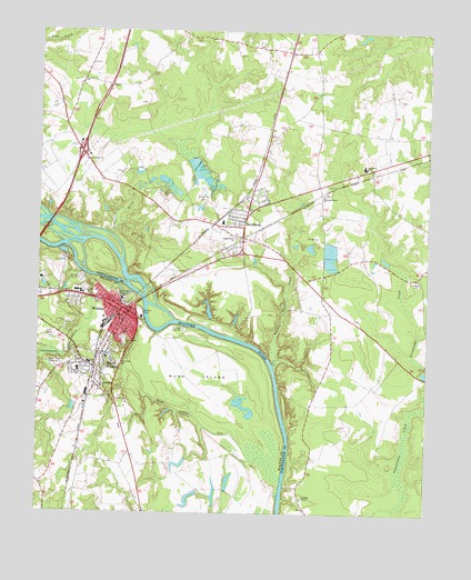
Weldon, NC USGS Topographic Map
Click on map above to begin viewing in our Map Viewer.

This topographic map contains these locations and features:
Feature Name Type Latitude Longitude GNIS ID View Map
Arthurs CreekStreamN36.4479°W77.6039°980298View Map
Cedarwood CemeteryCemeteryN36.4185°W77.5971°982907View Map
Chapel Grove ChurchChurchN36.4463°W77.5619°983011View Map
Chockoyotte CreekStreamN36.4367°W77.6093°983159View Map
GarysburgPopulated PlaceN36.4510°W77.5589°1020402View Map
Garysburg Elementary SchoolSchoolN36.4500°W77.5757°1006742View Map
Garysburg Fire DepartmentBuildingN36.4492°W77.5662°2638503View Map
Garysburg Police DepartmentBuildingN36.4490°W77.5656°2130887View Map
Garysburg Post OfficePost OfficeN36.4461°W77.5582°2774140View Map
Grace ChurchChurchN36.4252°W77.5983°985899View Map
Gumberry SchoolSchoolN36.4652°W77.5205°986255View Map
Mush IslandIslandN36.4102°W77.5739°990816View Map
Mush Island GutStreamN36.3754°W77.5464°990817View Map
Oak Grove ChurchChurchN36.4665°W77.6100°991405View Map
Oak Ridge CemeteryCemeteryN36.4139°W77.5986°991436View Map
Pearce Pond DamDamN36.3802°W77.5730°1000569View Map
Pearces PondReservoirN36.3775°W77.5756°1000568View Map
Roanoke ChapelChurchN36.3790°W77.5391°993410View Map
Roanoke-Salem ChurchChurchN36.4577°W77.5336°993425View Map
Saint Johns ChurchChurchN36.4354°W77.5025°993970View Map
South WeldonPopulated PlaceN36.4160°W77.6030°1022719View Map
South Weldon Census Designated PlaceCensusN36.4136°W77.6024°2402882View Map
Town of GarysburgCivilN36.4479°W77.5604°2406548View Map
Town of WeldonCivilN36.4210°W77.6135°2406855View Map
Township of OconeecheeCivilN36.3932°W77.5212°1027000View Map
Trouble Field CreekStreamN36.4138°W77.5489°996265View Map
WeldonPopulated PlaceN36.4271°W77.5955°1023152View Map
Weldon Elementary SchoolSchoolN36.4220°W77.5998°1006642View Map
Weldon Fire Department Station 1 HeadquartersBuildingN36.4267°W77.5954°2638169View Map
Weldon Fire Department Station 2BuildingN36.4318°W77.6178°2638402View Map
Weldon High SchoolSchoolN36.4124°W77.6126°996945View Map
Weldon Police DepartmentBuildingN36.4280°W77.5959°2130948View Map
Weldon Post OfficePost OfficeN36.4254°W77.5976°2773813View Map
WSMY-AM (Weldon)TowerN36.4121°W77.6180°1018568View Map

Note: Coordinates in the location and feature list above are referenced to NAD83 datum.


Copyright (C) 2008-2025 Ryan Niemi / Sunset Dynamics ... All Rights Reserved