TopoQuest Logo
Do you find TopoQuest useful?
Help keep TopoQuest running and adding new maps/features by donating!
Bitcoin:  19c7KJd3qBynnjoSw5npx9KScwjBe4ifkT
Litecoin:  LXs6TkuXGGXo1vDsWCkWVdjQX94eUKd6ui
Home View Maps Find Maps Find Places Resources & Links


Jackson Mountain, Arizona Topographic Map

USGS Map Title: Jackson Mountain, AZ
USGS Map MRC: 32110H2
DRG (GeoTIFF) Download: o32110h2.tif


Neighboring USGS Topographic Map Quads:


  Mount Turnbull, AZ  
33110A3
 

  Beargrass Basin, AZ  
33110A2
 

  Geronimo, AZ  
33110A1
 

  Cobre Grande Mountain, AZ  
32110H3
 

  Jackson Mountain, AZ  
32110H2
 

  Telegraph Wash, AZ  
32110H1
 

  Klondyke, AZ  
32110G3
 

  Buford Hill, AZ  
32110G2
 

  Tripp Canyon, AZ  
32110G1


Map MRC Location:

N33°
W111°
N33°
W110°
H8 H7 H6 H5 H4 H3 H2 H1
G8 G7 G6 G5 G4 G3 G2 G1
F8 F7 F6 F5 F4 F3 F2 F1
E8 E7 E6 E5 E4 E3 E2 E1
D8 D7 D6 D5 D4 D3 D2 D1
C8 C7 C6 C5 C4 C3 C2 C1
B8 B7 B6 B5 B4 B3 B2 B1
A8 A7 A6 A5 A4 A3 A2 A1
N32°
W111°
N32°
W110°

Jackson Mountain, AZ USGS 1:24K Topographic Map Preview:
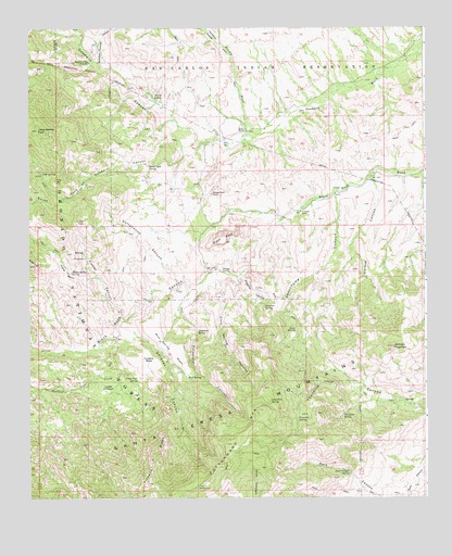
Jackson Mountain, AZ USGS Topographic Map
Click on map above to begin viewing in our Map Viewer.

This topographic map contains these locations and features:
Feature Name Type Latitude Longitude GNIS ID View Map
Beauchamp CanyonValleyN32.9545°W110.1531°1159View Map
Black RockSummitN32.9431°W110.1884°1588View Map
Black Rock CanyonValleyN32.9487°W110.1712°1596View Map
Black Rock Dam TankReservoirN32.9134°W110.2465°22415View Map
Black Rock Trail Two Hundred Ninety TwoTrailN32.9223°W110.2195°22416View Map
Brushy WashStreamN32.9712°W110.1815°2049View Map
Calf SpringSpringN32.9614°W110.2463°2373View Map
Cobre Grande PeakSummitN32.9731°W110.2473°3065View Map
Cold Spring CanyonValleyN32.9331°W110.1901°3107View Map
Cottonwood CanyonValleyN32.9317°W110.2031°3309View Map
Cottonwood MountainSummitN32.8778°W110.1970°3348View Map
Crows Nest SpringSpringN32.9063°W110.2161°3611View Map
Dark Canyon SpringSpringN32.8825°W110.1502°3705View Map
Fisher BasinBasinN32.9337°W110.2381°4625View Map
Fisher Basin SpringSpringN32.9344°W110.2370°4626View Map
Fisher Basin Trail Sixty fourTrailN32.9373°W110.2195°22488View Map
Fisher CanyonValleyN32.9231°W110.2206°4628View Map
Fourmile SpringSpringN32.8957°W110.1657°4790View Map
Gardner CanyonValleyN32.9215°W110.2212°4945View Map
Gardner Canyon Sixty seven TrailTrailN32.9167°W110.2006°22500View Map
Goodwin CanyonValleyN32.9695°W110.1956°5168View Map
Hackberry CanyonValleyN32.9959°W110.1901°5470View Map
Hinton RanchLocaleN32.9728°W110.1818°5839View Map
Holdout CreekStreamN32.9176°W110.2226°5875View Map
Holdout MesaSummitN32.9109°W110.2120°5876View Map
Holdup CanyonValleyN32.9578°W110.1406°5879View Map
Holladay RanchLocaleN32.9359°W110.1895°5889View Map
Jackson MountainSummitN32.9151°W110.1356°6327View Map
Kane SpringSpringN32.9202°W110.1663°6608View Map
Lone Pine SpringSpringN32.9007°W110.1749°7302View Map
Lower HoldoutBasinN32.9040°W110.2259°7471View Map
Mud SpringSpringN32.9071°W110.2006°8356View Map
Mud Spring MesaSummitN32.9140°W110.2048°8375View Map
North Santa Teresa WildernessReserveN32.9376°W110.1740°2035233View Map
Preacher CanyonValleyN32.9340°W110.1826°9754View Map
Preacher SpringSpringN32.9257°W110.1761°9755View Map
Rocky TopSummitN32.9370°W110.2481°10467View Map
Roundup Grounds CanyonValleyN32.9909°W110.2284°10559View Map
Santa Teresa MountainsRangeN32.8945°W110.1931°42895View Map
Santa Teresa WildernessReserveN32.9022°W110.2329°1955527View Map
South Fork Goodwin CanyonValleyN32.9695°W110.1956°11597View Map
South Fork SpringSpringN32.9639°W110.2125°11605View Map
South Goodwin SpringSpringN32.9557°W110.2352°22664View Map
Spar MineMineN32.9423°W110.1381°22668View Map
Sycamore CanyonValleyN32.9306°W110.1998°12073View Map
Sycamore SpringSpringN32.8972°W110.1513°12085View Map
Sycamore SpringSpringN32.9193°W110.1972°12086View Map
T Hinton RanchLocaleN32.9512°W110.1645°12097View Map
The BoxBasinN32.9581°W110.2329°12292View Map
White SpringSpringN32.9812°W110.2082°13668View Map

Note: Coordinates in the location and feature list above are referenced to NAD83 datum.


Copyright (C) 2008-2025 Ryan Niemi / Sunset Dynamics ... All Rights Reserved