TopoQuest Logo
Do you find TopoQuest useful?
Help keep TopoQuest running and adding new maps/features by donating!
Bitcoin:  19c7KJd3qBynnjoSw5npx9KScwjBe4ifkT
Litecoin:  LXs6TkuXGGXo1vDsWCkWVdjQX94eUKd6ui
Home View Maps Find Maps Find Places Resources & Links


Jacksonville East, Texas Topographic Map

USGS Map Title: Jacksonville East, TX
USGS Map MRC: 31095H2
DRG (GeoTIFF) Download: o31095h2.tif


Neighboring USGS Topographic Map Quads:


  Mount Selman, TX  
32095A3
 

  Tecula, TX  
32095A2
 

  Griffin, TX  
32095A1
 

  Jacksonville West, TX  
31095H3
 

  Jacksonville East, TX  
31095H2
 

  New Summerfield, TX  
31095H1
 

  Maydelle, TX  
31095G3
 

  Rusk, TX  
31095G2
 

  Atoy, TX  
31095G1


Map MRC Location:

N32°
W96°
N32°
W95°
H8 H7 H6 H5 H4 H3 H2 H1
G8 G7 G6 G5 G4 G3 G2 G1
F8 F7 F6 F5 F4 F3 F2 F1
E8 E7 E6 E5 E4 E3 E2 E1
D8 D7 D6 D5 D4 D3 D2 D1
C8 C7 C6 C5 C4 C3 C2 C1
B8 B7 B6 B5 B4 B3 B2 B1
A8 A7 A6 A5 A4 A3 A2 A1
N31°
W96°
N31°
W95°

Jacksonville East, TX USGS 1:24K Topographic Map Preview:
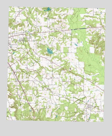
Jacksonville East, TX USGS Topographic Map
Click on map above to begin viewing in our Map Viewer.

This topographic map contains these locations and features:
Feature Name Type Latitude Longitude GNIS ID View Map
Afton Grove ChurchChurchN31.9774°W95.1966°1329244View Map
Barber BranchStreamN31.9782°W95.2102°1330024View Map
Bolton AirportAirportN31.9174°W95.2072°1386949View Map
Bridge CreekStreamN31.9849°W95.1622°1331257View Map
Caney CreekStreamN31.9918°W95.1605°1332082View Map
Cherokee Country ClubLocaleN31.9746°W95.2113°1384335View Map
Cherokee County Constable's Office Precinct 1BuildingN31.9662°W95.2315°2751423View Map
CHRISTUS Mother Frances Hospital - JacksonvilleHospitalN31.9385°W95.2478°2718933View Map
City of GallatinCivilN31.8969°W95.1521°2410561View Map
Coon CreekStreamN31.9324°W95.1319°1333284View Map
Corinth ChurchChurchN31.9227°W95.1922°1333360View Map
CraftPopulated PlaceN31.9182°W95.2355°1378176View Map
Drip Rock CreekStreamN31.9504°W95.2266°1334614View Map
Dry CreekStreamN31.9093°W95.1374°1334677View Map
First Baptist ChurchChurchN31.9660°W95.2497°2016658View Map
GallatinPopulated PlaceN31.8910°W95.1455°1336348View Map
Gallatin Post OfficePost OfficeN31.8942°W95.1450°2732091View Map
Gallatin Volunteer Fire DepartmentBuildingN31.8936°W95.1452°2655522View Map
Jacksonville Club LakeReservoirN31.9980°W95.1991°1338609View Map
Jacksonville Club Lake DamDamN31.9985°W95.1969°1855392View Map
Jacksonville Fire Department Station 2BuildingN31.9661°W95.2262°2655306View Map
Jarrett CemeteryCemeteryN31.9124°W95.2127°1338646View Map
Little Turnpike CreekStreamN31.8993°W95.1555°1340206View Map
MittiePopulated PlaceN31.9718°W95.2291°1378692View Map
Old Piney Grove CemeteryCemeteryN31.8754°W95.1597°1343195View Map
Pine Crest LakeReservoirN31.9518°W95.1966°1344042View Map
Pine Crest Lake DamDamN31.9502°W95.1919°1855394View Map
Piney Grove CemeteryCemeteryN31.8788°W95.1683°1344094View Map
Providence CemeteryCemeteryN31.8891°W95.2465°1344595View Map
Providence ChurchChurchN31.8841°W95.2469°1344600View Map
Ragsdale CreekStreamN31.9404°W95.1724°1375613View Map
Simmer LakeReservoirN31.9618°W95.1569°1855391View Map
Simmer Lake DamDamN31.9618°W95.1569°1855390View Map
Staton CemeteryCemeteryN31.9302°W95.1777°1347839View Map
Taylor CemeteryCemeteryN31.8760°W95.1458°1348287View Map
Texas Forest Service Jacksonville OfficeBuildingN31.9379°W95.2402°2655616View Map
Tilley CemeteryCemeteryN31.9766°W95.1886°1348566View Map
Turnbow LakeLakeN31.9376°W95.1473°1348900View Map
TurneyPopulated PlaceN31.9091°W95.1952°1379184View Map

Note: Coordinates in the location and feature list above are referenced to NAD83 datum.


Copyright (C) 2008-2025 Ryan Niemi / Sunset Dynamics ... All Rights Reserved