TopoQuest Logo
Do you find TopoQuest useful?
Help keep TopoQuest running and adding new maps/features by donating!
Bitcoin:  19c7KJd3qBynnjoSw5npx9KScwjBe4ifkT
Litecoin:  LXs6TkuXGGXo1vDsWCkWVdjQX94eUKd6ui
Home View Maps Find Maps Find Places Resources & Links


Tecula, Texas Topographic Map

USGS Map Title: Tecula, TX
USGS Map MRC: 32095A2
DRG (GeoTIFF) Download: o32095a2.tif


Neighboring USGS Topographic Map Quads:


  Bullard, TX  
32095B3
 

  Troup West, TX  
32095B2
 

  Troup East, TX  
32095B1
 

  Mount Selman, TX  
32095A3
 

  Tecula, TX  
32095A2
 

  Griffin, TX  
32095A1
 

  Jacksonville West, TX  
31095H3
 

  Jacksonville East, TX  
31095H2
 

  New Summerfield, TX  
31095H1


Map MRC Location:

N33°
W96°
N33°
W95°
H8 H7 H6 H5 H4 H3 H2 H1
G8 G7 G6 G5 G4 G3 G2 G1
F8 F7 F6 F5 F4 F3 F2 F1
E8 E7 E6 E5 E4 E3 E2 E1
D8 D7 D6 D5 D4 D3 D2 D1
C8 C7 C6 C5 C4 C3 C2 C1
B8 B7 B6 B5 B4 B3 B2 B1
A8 A7 A6 A5 A4 A3 A2 A1
N32°
W96°
N32°
W95°

Tecula, TX USGS 1:24K Topographic Map Preview:
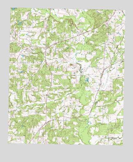
Tecula, TX USGS Topographic Map
Click on map above to begin viewing in our Map Viewer.

This topographic map contains these locations and features:
Feature Name Type Latitude Longitude GNIS ID View Map
Bear CreekStreamN32.0746°W95.1755°1330218View Map
Bell BranchStreamN32.0068°W95.1444°1330366View Map
Birches CreekStreamN32.0435°W95.1733°1330697View Map
Brock LakeReservoirN32.0661°W95.2379°1331295View Map
BrushyPopulated PlaceN32.0929°W95.1466°1378060View Map
Brushy CreekStreamN32.0354°W95.2474°1331434View Map
Bullard Club Lake DamDamN32.1118°W95.2369°1855402View Map
Caney CreekStreamN32.0229°W95.1644°1332083View Map
Club Lake BranchStreamN32.0002°W95.1708°1333016View Map
Dickey BranchStreamN32.0338°W95.1569°1334342View Map
Double BranchStreamN32.1240°W95.2191°1334522View Map
Goldy LakeLakeN32.0772°W95.1751°1336660View Map
GouldPopulated PlaceN32.0557°W95.1508°1378372View Map
Greenhead LakeReservoirN32.1109°W95.2391°1336967View Map
Hetty BranchStreamN32.0349°W95.2313°1337661View Map
Lavender BranchStreamN32.0521°W95.1713°1339723View Map
Miles LakeReservoirN32.1218°W95.2436°1855401View Map
Miles Lake DamDamN32.1218°W95.2436°1855400View Map
MixonPopulated PlaceN32.0888°W95.2102°1378693View Map
Mount Zion ChurchChurchN32.0510°W95.1369°1342143View Map
North Cherokee County Volunteer Fire Department Station 1BuildingN32.0909°W95.2062°2655700View Map
North Cherokee County Volunteer Fire Department Station 2BuildingN32.0192°W95.2103°2655343View Map
North Jacksonville Oil FieldOilfieldN32.0813°W95.2272°1342758View Map
Pine LakeLakeN32.0319°W95.1667°1344064View Map
Piney BranchStreamN32.0688°W95.1405°1344088View Map
Rocky PointSummitN32.0071°W95.2338°1345487View Map
Smith LakeReservoirN32.0161°W95.2347°1347279View Map
Stockton LakeLakeN32.0353°W95.1718°1347950View Map
Taylors ChapelChurchN32.0452°W95.2091°1348307View Map
TeculaPopulated PlaceN32.0199°W95.2094°1379143View Map
Tecula CemeteryCemeteryN32.0282°W95.1986°1348322View Map
Twin LakesLakeN32.0596°W95.1647°1348950View Map
Wallace BranchStreamN32.0354°W95.2474°1349389View Map
West Mud CreekStreamN32.1168°W95.1663°1376713View Map

Note: Coordinates in the location and feature list above are referenced to NAD83 datum.


Copyright (C) 2008-2025 Ryan Niemi / Sunset Dynamics ... All Rights Reserved