TopoQuest Logo
Do you find TopoQuest useful?
Help keep TopoQuest running and adding new maps/features by donating!
Bitcoin:  19c7KJd3qBynnjoSw5npx9KScwjBe4ifkT
Litecoin:  LXs6TkuXGGXo1vDsWCkWVdjQX94eUKd6ui
Home View Maps Find Maps Find Places Resources & Links


Jaybird, Ohio Topographic Map

USGS Map Title: Jaybird, OH
USGS Map MRC: 38083H3
DRG (GeoTIFF) Download: o38083h3.tif


Neighboring USGS Topographic Map Quads:


  Sinking Spring, OH  
39083A4
 

  Byington, OH  
39083A3
 

  Latham, OH  
39083A2
 

  Peebles, OH  
38083H4
 

  Jaybird, OH  
38083H3
 

  Rarden, OH  
38083H2
 

  Lynx, OH  
38083G4
 

  Blue Creek, OH  
38083G3
 

  Otway, OH  
38083G2


Map MRC Location:

N39°
W84°
N39°
W83°
H8 H7 H6 H5 H4 H3 H2 H1
G8 G7 G6 G5 G4 G3 G2 G1
F8 F7 F6 F5 F4 F3 F2 F1
E8 E7 E6 E5 E4 E3 E2 E1
D8 D7 D6 D5 D4 D3 D2 D1
C8 C7 C6 C5 C4 C3 C2 C1
B8 B7 B6 B5 B4 B3 B2 B1
A8 A7 A6 A5 A4 A3 A2 A1
N38°
W84°
N38°
W83°

Jaybird, OH USGS 1:24K Topographic Map Preview:
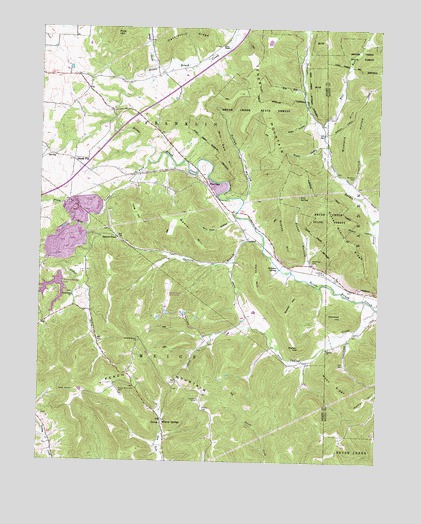
Jaybird, OH USGS Topographic Map
Click on map above to begin viewing in our Map Viewer.

This topographic map contains these locations and features:
Feature Name Type Latitude Longitude GNIS ID View Map
Adams QuarryMineN38.9542°W83.3100°2703611View Map
Aikens CemeteryCemeteryN38.8901°W83.3141°1037335View Map
Bacon FlatPopulated PlaceN38.9617°W83.3627°1062639View Map
Bacon Flat School (historical)SchoolN38.9617°W83.3627°1055811View Map
Beaver PondPopulated PlaceN38.9395°W83.3463°1062645View Map
Beaverpond Post Office (historical)Post OfficeN38.9395°W83.3463°1956154View Map
Bettys CreekStreamN38.9887°W83.3344°1037973View Map
Big RunStreamN38.9787°W83.2774°1038016View Map
Bull RunStreamN38.9690°W83.2710°1038514View Map
Burns ChapelChurchN38.9953°W83.3071°1038540View Map
Carey HillSummitN38.9290°W83.2946°1038811View Map
Cedar ForkStreamN38.9615°W83.3355°1038894View Map
Cedar Fork CemeteryCemeteryN38.9234°W83.3627°1731178View Map
Cedar Fork ChurchChurchN38.9226°W83.3624°1038893View Map
Claylick HollowValleyN38.9553°W83.2588°1039150View Map
Coffee HollowValleyN38.9509°W83.2985°1039224View Map
Davis Memorial Nature PreserveParkN38.9390°W83.3566°1731181View Map
Dry ForkStreamN38.9445°W83.2519°1039795View Map
Dunlap ChurchChurchN38.9076°W83.2685°1039882View Map
Dunlap CreekStreamN38.9192°W83.2505°1039883View Map
Dunlap School (historical)SchoolN38.9078°W83.2680°1049490View Map
Elder HollowValleyN38.9728°W83.2774°1040107View Map
General Electric Airport (historical)AirportN38.9220°W83.3277°1082948View Map
Grassy HillSummitN38.9176°W83.2838°1041069View Map
Graves HillRidgeN38.9437°W83.2852°1041083View Map
Iron SpringSpringN38.9518°W83.2793°1041997View Map
JaybirdPopulated PlaceN38.9395°W83.2982°1064902View Map
Jaybird BranchStreamN38.9367°W83.2924°1042056View Map
Jaybird CemeteryCemeteryN38.9392°W83.3013°1731191View Map
Jaybird Post Office (historical)Post OfficeN38.9395°W83.2982°1956648View Map
Mill Dam HillRidgeN38.9645°W83.3077°1043331View Map
Mineral SpringsPopulated PlaceN38.8870°W83.3294°1065033View Map
Mineral Springs LakeReservoirN38.9204°W83.3691°1078062View Map
Mineral Springs Lake DamDamN38.9284°W83.3682°1078061View Map
Mineral Springs Post Office (historical)Post OfficeN38.8870°W83.3294°1956619View Map
Mineral Springs Station (historical)LocaleN38.9417°W83.2999°1055884View Map
Moon RidgeRidgeN38.8984°W83.2660°1048345View Map
Mustard CemeteryCemeteryN38.9567°W83.2596°1043747View Map
Mustard HillSummitN38.9678°W83.2627°1043749View Map
Newman CemeteryCemeteryN38.9334°W83.2743°1043860View Map
Newman HillSummitN38.9173°W83.2630°1043863View Map
O'Bryant School (historical)SchoolN38.9862°W83.2627°1049491View Map
Peach MountainSummitN38.8953°W83.3619°1049365View Map
Peach Mountain CemeteryCemeteryN38.8953°W83.3449°1044344View Map
Peach Mountain ChurchChurchN38.9098°W83.3377°1044345View Map
Peach Mountain School (historical)SchoolN38.9098°W83.3374°1055903View Map
Pine GapPopulated PlaceN38.9567°W83.3141°1062940View Map
Pine HillSummitN38.9995°W83.3488°1049083View Map
Pleasant ValleyValleyN38.9895°W83.3335°1044592View Map
Plum RunStreamN38.9426°W83.3577°1044647View Map
Poker HollowValleyN38.9320°W83.2763°1044661View Map
Rarden CreekStreamN38.9209°W83.2513°1066919View Map
Sink Hole HollowValleyN38.9442°W83.3044°1046301View Map
Snake HollowValleyN38.9662°W83.2727°1046395View Map
Stone BranchStreamN38.9495°W83.3732°1048424View Map
Stone Quarry RidgeRidgeN38.9442°W83.2660°1046712View Map
Straight ForkStreamN38.9690°W83.2710°1070956View Map
Sulphur SpringSpringN38.9312°W83.2872°1048378View Map
Tener MountainSummitN38.9798°W83.2955°1049243View Map
Tolle HillSummitN38.9467°W83.3405°1047087View Map
Township of FranklinCivilN38.9862°W83.3312°1085676View Map
Turkey Creek ChurchChurchN38.8878°W83.3749°1047196View Map
Walker HillSummitN38.9081°W83.2785°1047504View Map
Weaver HillSummitN38.9467°W83.3305°1047645View Map
Wildcat HollowValleyN38.9417°W83.2524°1048387View Map

Note: Coordinates in the location and feature list above are referenced to NAD83 datum.


Copyright (C) 2008-2025 Ryan Niemi / Sunset Dynamics ... All Rights Reserved