TopoQuest Logo
Do you find TopoQuest useful?
Help keep TopoQuest running and adding new maps/features by donating!
Bitcoin:  19c7KJd3qBynnjoSw5npx9KScwjBe4ifkT
Litecoin:  LXs6TkuXGGXo1vDsWCkWVdjQX94eUKd6ui
Home View Maps Find Maps Find Places Resources & Links


Rarden, Ohio Topographic Map

USGS Map Title: Rarden, OH
USGS Map MRC: 38083H2
DRG (GeoTIFF) Download: o38083h2.tif


Neighboring USGS Topographic Map Quads:


  Byington, OH  
39083A3
 

  Latham, OH  
39083A2
 

  Piketon, OH  
39083A1
 

  Jaybird, OH  
38083H3
 

  Rarden, OH  
38083H2
 

  Wakefield, OH  
38083H1
 

  Blue Creek, OH  
38083G3
 

  Otway, OH  
38083G2
 

  West Portsmouth, OH  
38083G1


Map MRC Location:

N39°
W84°
N39°
W83°
H8 H7 H6 H5 H4 H3 H2 H1
G8 G7 G6 G5 G4 G3 G2 G1
F8 F7 F6 F5 F4 F3 F2 F1
E8 E7 E6 E5 E4 E3 E2 E1
D8 D7 D6 D5 D4 D3 D2 D1
C8 C7 C6 C5 C4 C3 C2 C1
B8 B7 B6 B5 B4 B3 B2 B1
A8 A7 A6 A5 A4 A3 A2 A1
N38°
W84°
N38°
W83°

Rarden, OH USGS 1:24K Topographic Map Preview:
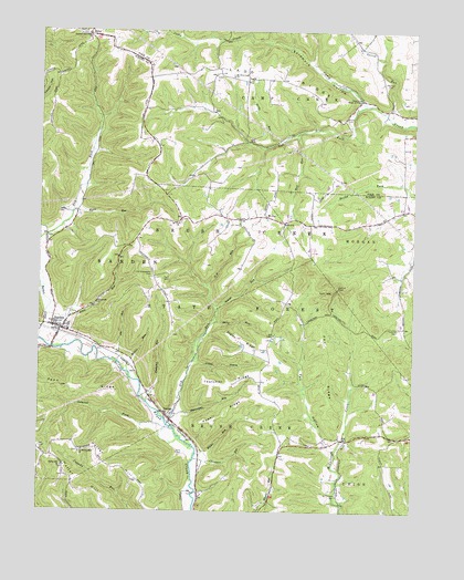
Rarden, OH USGS Topographic Map
Click on map above to begin viewing in our Map Viewer.

This topographic map contains these locations and features:
Feature Name Type Latitude Longitude GNIS ID View Map
Abe RunStreamN38.9142°W83.2235°1037302View Map
Brown CemeteryCemeteryN38.9776°W83.1480°1038367View Map
Brush Creek State ForestParkN38.8834°W83.1332°1062579View Map
Camp Creek House of PrayerChurchN38.9823°W83.1427°1038689View Map
Chambers RunStreamN38.8884°W83.1968°1038977View Map
Copasville ChurchChurchN38.9295°W83.2305°1039359View Map
Crabtree CemeteryCemeteryN38.9230°W83.1300°1039434View Map
Crabtree School (historical)SchoolN38.9215°W83.1282°1049486View Map
Drake RunStreamN38.9712°W83.1702°1039781View Map
Dry RunStreamN38.8973°W83.2052°1039808View Map
DukePopulated PlaceN38.9990°W83.2335°1062736View Map
Duke Post Office (historical)Post OfficeN38.9987°W83.2332°2044005View Map
Early CemeteryCemeteryN38.8901°W83.2032°1039930View Map
Fen HollowValleyN38.8948°W83.1541°1040413View Map
Fen RidgeRidgeN38.9120°W83.1521°1040414View Map
Hackworth Hill School (historical)SchoolN38.9328°W83.2085°1049488View Map
Harmon CemeteryCemeteryN38.9987°W83.2346°1041322View Map
Harmon-salt Creek ChurchChurchN38.9987°W83.2338°1041333View Map
Hoffer HillSummitN38.8845°W83.2235°1041641View Map
Hoffer Hill CemeteryCemeteryN38.8903°W83.2363°1964229View Map
Hoffer Hill ChurchChurchN38.8865°W83.2419°1041642View Map
Jessie RunStreamN38.9176°W83.2452°1042094View Map
Kizzie RunStreamN38.9526°W83.2388°1042311View Map
LaddPopulated PlaceN38.9873°W83.1807°1080499View Map
Ladd Post Office (historical)Post OfficeN38.9876°W83.1805°2042464View Map
Ladd RidgeRidgeN38.9890°W83.1730°1042366View Map
Laurel ForkStreamN38.8973°W83.2068°1042438View Map
Left Fork Camp CreekStreamN38.9809°W83.1396°1063462View Map
McBridge School (historical)SchoolN38.9501°W83.2135°1049489View Map
Mechlin CemeteryCemeteryN38.9870°W83.1355°1043202View Map
Mount Hope School (historical)SchoolN38.9140°W83.1724°1049487View Map
Mount JoyPopulated PlaceN38.9515°W83.1735°1061135View Map
Mount Joy CemeteryCemeteryN38.9503°W83.2030°1964234View Map
Mount Joy Post Office (historical)Post OfficeN38.9515°W83.1735°2044047View Map
Mount Olive CemeteryCemeteryN38.9884°W83.1863°1963414View Map
Mount Olive-Ladd ChurchChurchN38.9881°W83.1852°1043528View Map
Mullen RunStreamN38.9115°W83.2196°1043728View Map
Old Hackworth CemeteryCemeteryN38.9362°W83.2121°1044108View Map
Old Hoffer Hill ChurchChurchN38.8901°W83.2360°1044110View Map
Penn RidgeRidgeN38.9073°W83.2424°1044368View Map
Powell RidgeRidgeN38.9009°W83.1868°1044735View Map
RardenPopulated PlaceN38.9223°W83.2424°1061585View Map
Rarden Post OfficePost OfficeN38.9223°W83.2424°2044070View Map
Rarden Volunteer Fire DepartmentBuildingN38.9227°W83.2454°2550368View Map
Rock RunStreamN38.9734°W83.1635°1045117View Map
Saint Patricks CemeteryCemeteryN38.8798°W83.1496°1045726View Map
Salome RunStreamN38.9270°W83.1902°1045906View Map
Scioto Ambulance District Squad 4BuildingN38.9226°W83.2448°2550894View Map
Skidmore HollowValleyN38.9834°W83.1435°1046317View Map
Spunk RunStreamN38.9770°W83.1324°1046608View Map
Staley RidgeRidgeN38.9167°W83.1752°1046622View Map
Staley RunStreamN38.9242°W83.1902°1046623View Map
Sugarcamp RunStreamN38.9001°W83.2041°1046838View Map
Thatcher RidgeRidgeN38.9084°W83.1852°1046999View Map
Thompson RunStreamN38.9034°W83.2132°1047041View Map
Toms HollowValleyN38.9134°W83.1963°1047090View Map
Township of Camp CreekCivilN38.9798°W83.1329°1086809View Map
Township of RardenCivilN38.9439°W83.2329°1086934View Map
Up CemeteryCemeteryN38.9498°W83.1824°1047364View Map
Up RunStreamN38.9340°W83.1932°1047365View Map
Village of RardenCivilN38.9233°W83.2424°2399044View Map
Whites RunStreamN38.8904°W83.1935°1047883View Map
Young CemeteryCemeteryN38.8973°W83.2041°1964240View Map
Young Post Office (historical)Post OfficeN38.9004°W83.2055°2043942View Map
YoungsPopulated PlaceN38.8987°W83.2060°1049358View Map

Note: Coordinates in the location and feature list above are referenced to NAD83 datum.


Copyright (C) 2008-2024 Ryan Niemi / Sunset Dynamics ... All Rights Reserved