TopoQuest Logo
Do you find TopoQuest useful?
Help keep TopoQuest running and adding new maps/features by donating!
Bitcoin:  19c7KJd3qBynnjoSw5npx9KScwjBe4ifkT
Litecoin:  LXs6TkuXGGXo1vDsWCkWVdjQX94eUKd6ui
Home View Maps Find Maps Find Places Resources & Links


Peebles, Ohio Topographic Map

USGS Map Title: Peebles, OH
USGS Map MRC: 38083H4
DRG (GeoTIFF) Download: o38083h4.tif


Neighboring USGS Topographic Map Quads:


  Belfast, OH  
39083A5
 

  Sinking Spring, OH  
39083A4
 

  Byington, OH  
39083A3
 

  Seaman, OH  
38083H5
 

  Peebles, OH  
38083H4
 

  Jaybird, OH  
38083H3
 

  West Union, OH  
38083G5
 

  Lynx, OH  
38083G4
 

  Blue Creek, OH  
38083G3


Map MRC Location:

N39°
W84°
N39°
W83°
H8 H7 H6 H5 H4 H3 H2 H1
G8 G7 G6 G5 G4 G3 G2 G1
F8 F7 F6 F5 F4 F3 F2 F1
E8 E7 E6 E5 E4 E3 E2 E1
D8 D7 D6 D5 D4 D3 D2 D1
C8 C7 C6 C5 C4 C3 C2 C1
B8 B7 B6 B5 B4 B3 B2 B1
A8 A7 A6 A5 A4 A3 A2 A1
N38°
W84°
N38°
W83°

Peebles, OH USGS 1:24K Topographic Map Preview:
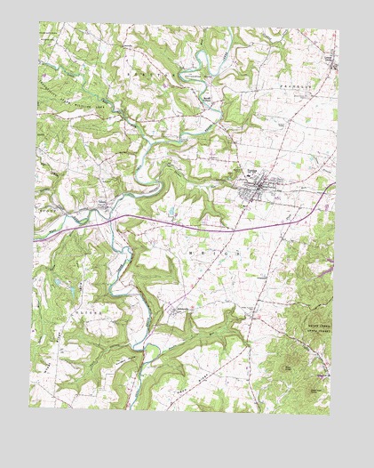
Peebles, OH USGS Topographic Map
Click on map above to begin viewing in our Map Viewer.

This topographic map contains these locations and features:
Feature Name Type Latitude Longitude GNIS ID View Map
Big RunStreamN38.9445°W83.4921°1038024View Map
Bundle RunStreamN38.8934°W83.4457°1038517View Map
Deer Lick KnobSummitN38.8826°W83.3838°1048654View Map
Evergreen CemeteryCemeteryN38.9195°W83.4013°1731183View Map
Evergreen ChurchChurchN38.9192°W83.4024°1040281View Map
Franklin Township Fire DepartmentBuildingN38.9885°W83.3776°2550209View Map
Georges CreekStreamN38.9376°W83.4866°1065793View Map
Holy Trinity Catholic ChurchChurchN38.9526°W83.4074°1731221View Map
Hoop RidgeRidgeN38.8820°W83.4419°1041749View Map
Hoop Ridge School (historical)SchoolN38.8809°W83.4341°1055857View Map
Horseshoe BendBendN38.9842°W83.4299°1041805View Map
JacksonvillePopulated PlaceN38.9081°W83.4399°1064897View Map
Jacksonville CemeteryCemeteryN38.9112°W83.4360°1731190View Map
Jacksonville Post Office (historical)Post OfficeN38.9081°W83.4399°1956647View Map
LawshePopulated PlaceN38.9406°W83.4696°1048909View Map
Lawshe CemeteryCemeteryN38.9426°W83.4674°1731192View Map
Lawshe Post Office (historical)Post OfficeN38.9406°W83.4696°1956645View Map
Laycocks Farm Pond Dam Number OneDamN38.9134°W83.4832°1078063View Map
Laycocks Farm Pond Dam Number TwoDamN38.9167°W83.4899°1078065View Map
Laycocks Farm Pond Number OneReservoirN38.9130°W83.4830°1078064View Map
Laycocks Farm Pond Number TwoReservoirN38.9158°W83.4896°1078066View Map
Lewis AirportAirportN38.9339°W83.3965°1082949View Map
Little East Fork Ohio Brush CreekStreamN38.9612°W83.4519°1042660View Map
Locust GrovePopulated PlaceN38.9884°W83.3780°1057814View Map
Locust Grove CemeteryCemeteryN38.9784°W83.3869°1042708View Map
Locust Grove Wesleyan ChurchChurchN38.9931°W83.3769°1731222View Map
Locustgrove Post Office (historical)Post OfficeN38.9884°W83.3780°1956650View Map
Locustgrove Post Office (historical)Post OfficeN38.9890°W83.3777°1956750View Map
LouisvillePopulated PlaceN38.9928°W83.4644°1062859View Map
Louisville CemeteryCemeteryN38.9917°W83.4627°1731194View Map
Marble FurnacePopulated PlaceN38.9751°W83.4274°1065722View Map
Marble Furnace CemeteryCemeteryN38.9745°W83.4321°1731197View Map
Marble Furnace Post Office (historical)Post OfficeN38.9751°W83.4274°1956751View Map
Measley School (historical)SchoolN38.9340°W83.4432°1055882View Map
Murphin PointCliffN38.8915°W83.4566°1043739View Map
Palestine School (historical)SchoolN38.9734°W83.3916°1055901View Map
PeeblesPopulated PlaceN38.9490°W83.4057°1044358View Map
Peebles Fire DepartmentBuildingN38.9485°W83.4009°2550179View Map
Peebles High SchoolSchoolN38.9520°W83.4116°1055904View Map
Peebles Life Squad - Adams City Emergency Medical ServicesBuildingN38.9510°W83.4118°2550856View Map
Peebles Police DepartmentBuildingN38.9512°W83.4104°2732718View Map
Peebles Post OfficePost OfficeN38.9501°W83.4041°1958748View Map
Polk HollowValleyN38.8965°W83.4588°1044669View Map
Praise and Worship ChurchChurchN38.9490°W83.4030°1731223View Map
Rose Hill SchoolSchoolN38.9565°W83.4699°1055911View Map
Shimer RunStreamN38.9492°W83.4496°1066199View Map
Spoon RiverStreamN38.9345°W83.4799°1046534View Map
Steam FurnacePopulated PlaceN38.9059°W83.4082°1068994View Map
Steam Furnace CemeteryCemeteryN38.9090°W83.4077°1046661View Map
Steam Furnace School (historical)SchoolN38.9087°W83.4074°1055924View Map
Tater RidgeRidgeN38.9181°W83.4774°1046958View Map
Tater Ridge School (historical)SchoolN38.9051°W83.4832°1055931View Map
Township of MeigsCivilN38.9055°W83.3800°1085681View Map
Tranquility State Wildlife AreaParkN38.9840°W83.4955°1047131View Map
Village of PeeblesCivilN38.9463°W83.4094°2399644View Map
West Fork Ohio Brush CreekStreamN38.9367°W83.4685°1047724View Map
Wheat RidgeRidgeN38.8870°W83.4905°1047842View Map
Wolf CreekStreamN38.9920°W83.4305°1048034View Map

Note: Coordinates in the location and feature list above are referenced to NAD83 datum.


Copyright (C) 2008-2024 Ryan Niemi / Sunset Dynamics ... All Rights Reserved