TopoQuest Logo
Do you find TopoQuest useful?
Help keep TopoQuest running and adding new maps/features by donating!
Bitcoin:  19c7KJd3qBynnjoSw5npx9KScwjBe4ifkT
Litecoin:  LXs6TkuXGGXo1vDsWCkWVdjQX94eUKd6ui
Home View Maps Find Maps Find Places Resources & Links


Baldy Mountain, Arizona Topographic Map

USGS Map Title: Baldy Mountain, AZ
USGS Map MRC: 33112G3
DRG (GeoTIFF) Download: o33112g3.tif


Neighboring USGS Topographic Map Quads:


  Garfias Mountain, AZ  
33112H4
 

  Governors Peak, AZ  
33112H3
 

  New River, AZ  
33112H2
 

  Hieroglyphic Mountains SW, AZ  
33112G4
 

  Baldy Mountain, AZ  
33112G3
 

  Biscuit Flat, AZ  
33112G2
 

  McMicken Dam, AZ  
33112F4
 

  Calderwood Butte, AZ  
33112F3
 

  Hedgpeth Hills, AZ  
33112F2


Map MRC Location:

N34°
W113°
N34°
W112°
H8 H7 H6 H5 H4 H3 H2 H1
G8 G7 G6 G5 G4 G3 G2 G1
F8 F7 F6 F5 F4 F3 F2 F1
E8 E7 E6 E5 E4 E3 E2 E1
D8 D7 D6 D5 D4 D3 D2 D1
C8 C7 C6 C5 C4 C3 C2 C1
B8 B7 B6 B5 B4 B3 B2 B1
A8 A7 A6 A5 A4 A3 A2 A1
N33°
W113°
N33°
W112°

Baldy Mountain, AZ USGS 1:24K Topographic Map Preview:
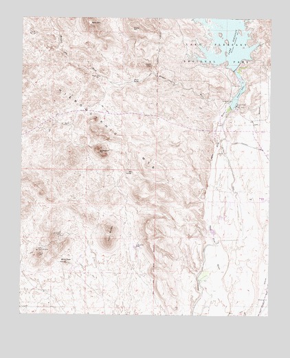
Baldy Mountain, AZ USGS Topographic Map
Click on map above to begin viewing in our Map Viewer.

This topographic map contains these locations and features:
Feature Name Type Latitude Longitude GNIS ID View Map
Baldy MountainSummitN33.8725°W112.3413°984View Map
Big SpringSpringN33.8106°W112.3201°1371View Map
Blackstone Country ClubLocaleN33.7622°W112.3234°2670244View Map
Burro SpringSpringN33.8479°W112.3174°2261View Map
Camp Dyer Diversion DamDamN33.8384°W112.2707°14274View Map
Carl Pleasant DamDamN33.8534°W112.2693°23880View Map
Caterpillar TankReservoirN33.7787°W112.3183°2563View Map
Chalky SpringSpringN33.8548°W112.3111°2737View Map
Cholla MountainSummitN33.8709°W112.3204°2885View Map
City of PeoriaCivilN33.7844°W112.2989°2411401View Map
Clementine Mine Airport (historical)AirportN33.7803°W112.3446°45514View Map
Coyote SpringsSpringN33.8692°W112.3691°3504View Map
East Garambullo WashStreamN33.7623°W112.3241°25466View Map
Garambullo WashStreamN33.7603°W112.3241°25464View Map
Lake Carl PleasantLocaleN33.8386°W112.2668°23897View Map
Lake PleasantReservoirN33.8534°W112.2693°9580View Map
Lake Pleasant (historical)LocaleN33.8667°W112.2674°23933View Map
Lake Pleasant InnLocaleN33.8386°W112.2668°6844View Map
Lake Pleasant Landing Field (historical)AirportN33.8264°W112.2690°14663View Map
Lower LakeReservoirN33.8412°W112.2680°7482View Map
Morgan City WashStreamN33.8214°W112.2763°8286View Map
Morgan City WellWellN33.8503°W112.3368°8287View Map
New Waddell Dam HeliportAirportN33.8450°W112.2704°45441View Map
Peoria Fire Department Station 199 Pleasant Harbor MarinaBuildingN33.8501°W112.2501°2672619View Map
Pleasant Harbor MarinaHarborN33.8504°W112.2601°2670000View Map
Pleasant Harbor Recreational Vehicle ResortLocaleN33.8460°W112.2510°2670447View Map
Prince MineMineN33.7773°W112.3657°9782View Map
Saddleback MountainSummitN33.8189°W112.3366°10655View Map
Twin ButtesSummitN33.7861°W112.3310°12931View Map
VistanciaPopulated PlaceN33.7528°W112.3281°2740608View Map
Vistancia Elementary SchoolSchoolN33.7556°W112.3324°2517864View Map
West Fork White Peak WashStreamN33.7634°W112.3396°25462View Map
West Garambullo WashStreamN33.7623°W112.3241°25463View Map
White PeakSummitN33.7723°W112.3524°13643View Map
White Peak MineMineN33.7839°W112.3543°13644View Map
Windy WellWellN33.8298°W112.3543°13923View Map

Note: Coordinates in the location and feature list above are referenced to NAD83 datum.


Copyright (C) 2008-2025 Ryan Niemi / Sunset Dynamics ... All Rights Reserved