TopoQuest Logo
Do you find TopoQuest useful?
Help keep TopoQuest running and adding new maps/features by donating!
Bitcoin:  19c7KJd3qBynnjoSw5npx9KScwjBe4ifkT
Litecoin:  LXs6TkuXGGXo1vDsWCkWVdjQX94eUKd6ui
Home View Maps Find Maps Find Places Resources & Links


Collins, Arkansas Topographic Map

USGS Map Title: Collins, AR
USGS Map MRC: 33091E5
DRG (GeoTIFF) Download: o33091e5.tif


Neighboring USGS Topographic Map Quads:


  Collins NW, AR  
33091F6
 

  Selma, AR  
33091F5
 

  McGehee North, AR  
33091F4
 

  Cominto, AR  
33091E6
 

  Collins, AR  
33091E5
 

  McGehee South, AR  
33091E4
 

  Mist NW, AR  
33091D6
 

  Line, AR  
33091D5
 

  Jerome, AR  
33091D4


Map MRC Location:

N34°
W92°
N34°
W91°
H8 H7 H6 H5 H4 H3 H2 H1
G8 G7 G6 G5 G4 G3 G2 G1
F8 F7 F6 F5 F4 F3 F2 F1
E8 E7 E6 E5 E4 E3 E2 E1
D8 D7 D6 D5 D4 D3 D2 D1
C8 C7 C6 C5 C4 C3 C2 C1
B8 B7 B6 B5 B4 B3 B2 B1
A8 A7 A6 A5 A4 A3 A2 A1
N33°
W92°
N33°
W91°

Collins, AR USGS 1:24K Topographic Map Preview:
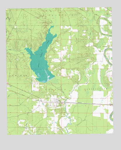
Collins, AR USGS Topographic Map
Click on map above to begin viewing in our Map Viewer.

This topographic map contains these locations and features:
Feature Name Type Latitude Longitude GNIS ID View Map
Big LakeLakeN33.5810°W91.6050°74668View Map
Bowden CemeteryCemeteryN33.5640°W91.5485°46850View Map
Bynum LakeReservoirN33.5056°W91.5656°80475View Map
Bynum Lake DamDamN33.5051°W91.5651°80474View Map
Chinquapin CreekStreamN33.5829°W91.6240°47755View Map
CollinsPopulated PlaceN33.5315°W91.5654°76653View Map
Collins CemeteryCemeteryN33.5287°W91.5623°78985View Map
Collins Cominto Fire Station 1BuildingN33.5322°W91.5655°2116289View Map
Collins Cominto Fire Station 2BuildingN33.5473°W91.6157°2116290View Map
Collins Missionary Baptist ChurchChurchN33.5329°W91.5687°78986View Map
Collins School (historical)SchoolN33.5301°W91.5671°78987View Map
Dry BayouStreamN33.5359°W91.5532°48617View Map
Gethsemane ChurchChurchN33.5490°W91.6212°49386View Map
KXSA-FM (Dermott)TowerN33.5323°W91.5746°85174View Map
Little Cutoff CreekStreamN33.5846°W91.6226°51250View Map
Little Zion ChurchChurchN33.5862°W91.5060°51345View Map
Mills CreekStreamN33.6234°W91.5229°52080View Map
Mount Olive CemeteryCemeteryN33.5648°W91.5507°52328View Map
Northern BrakeSwampN33.6124°W91.5061°52844View Map
Ruby School (historical)SchoolN33.5418°W91.5996°79087View Map
Sandy CreekStreamN33.5846°W91.6035°78296View Map
Seven Devils LakeReservoirN33.5687°W91.5838°78314View Map
Seven Devils Swamp DamDamN33.5534°W91.5751°81273View Map
Solomon Allen CemeteryCemeteryN33.5815°W91.5140°54999View Map

Note: Coordinates in the location and feature list above are referenced to NAD83 datum.


Copyright (C) 2008-2025 Ryan Niemi / Sunset Dynamics ... All Rights Reserved