TopoQuest Logo
Do you find TopoQuest useful?
Help keep TopoQuest running and adding new maps/features by donating!
Bitcoin:  19c7KJd3qBynnjoSw5npx9KScwjBe4ifkT
Litecoin:  LXs6TkuXGGXo1vDsWCkWVdjQX94eUKd6ui
Home View Maps Find Maps Find Places Resources & Links


Johns Peak, Utah Topographic Map

USGS Map Title: Johns Peak, UT
USGS Map MRC: 38111F4
DRG (GeoTIFF) Download: o38111f4.tif


Neighboring USGS Topographic Map Quads:


  Yogo Creek, UT  
38111G5
 

  Old Woman Plateau, UT  
38111G4
 

  Walker Flat, UT  
38111G3
 

  Hilgard Mountain, UT  
38111F5
 

  Johns Peak, UT  
38111F4
 

  Willow Springs, UT  
38111F3
 

  Forsyth Reservoir, UT  
38111E5
 

  Geyser Peak, UT  
38111E4
 

  Solomons Temple, UT  
38111E3


Map MRC Location:

N39°
W112°
N39°
W111°
H8 H7 H6 H5 H4 H3 H2 H1
G8 G7 G6 G5 G4 G3 G2 G1
F8 F7 F6 F5 F4 F3 F2 F1
E8 E7 E6 E5 E4 E3 E2 E1
D8 D7 D6 D5 D4 D3 D2 D1
C8 C7 C6 C5 C4 C3 C2 C1
B8 B7 B6 B5 B4 B3 B2 B1
A8 A7 A6 A5 A4 A3 A2 A1
N38°
W112°
N38°
W111°

Johns Peak, UT USGS 1:24K Topographic Map Preview:
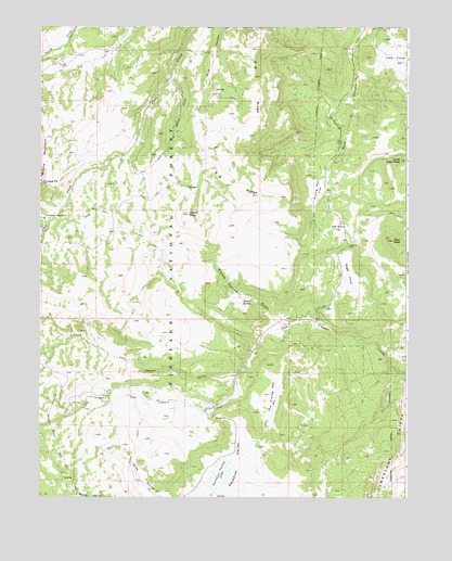
Johns Peak, UT USGS Topographic Map
Click on map above to begin viewing in our Map Viewer.

This topographic map contains these locations and features:
Feature Name Type Latitude Longitude GNIS ID View Map
Alice MountSummitN38.7466°W111.4624°1455165View Map
Deer PeakSummitN38.6933°W111.3805°1440391View Map
Elk CampgroundLocaleN38.6519°W111.4771°1440898View Map
Frying Pan FlatFlatN38.7066°W111.4057°1441252View Map
Horse ForkStreamN38.7369°W111.4555°1441873View Map
Jims FarmFlatN38.7411°W111.3791°1442148View Map
Johns PeakSummitN38.7005°W111.4496°1442172View Map
Kinneys MeadowFlatN38.6986°W111.4952°1442338View Map
Kinneys PeakSummitN38.7086°W111.4996°1442339View Map
Little Deer PeakSummitN38.7144°W111.3777°1442699View Map
Middle MountainSummitN38.7086°W111.4993°1443363View Map
North Fork Clear CreekStreamN38.6989°W111.4971°1443894View Map
North Last Chance CreekStreamN38.6578°W111.4327°1443955View Map
Paradise ValleyBasinN38.6294°W111.4363°1444197View Map
Paradise Valley LakeLakeN38.6308°W111.4386°1444198View Map
Poverty FlatFlatN38.6903°W111.4274°1454974View Map
Round SpringSpringN38.6775°W111.4284°1445176View Map
Round Spring DrawValleyN38.6730°W111.4216°1445177View Map
S B RidgeRidgeN38.7219°W111.4307°1445216View Map
Sage HoleBasinN38.6803°W111.3985°1445246View Map
Sign Board FlatFlatN38.6966°W111.3980°1445579View Map
South Last Chance CreekStreamN38.6578°W111.4324°1445900View Map
The Frying PanFlatN38.6522°W111.4221°1446448View Map
WhipupPopulated PlaceN38.6916°W111.3941°1447224View Map

Note: Coordinates in the location and feature list above are referenced to NAD83 datum.


Copyright (C) 2008-2025 Ryan Niemi / Sunset Dynamics ... All Rights Reserved