TopoQuest Logo
Do you find TopoQuest useful?
Help keep TopoQuest running and adding new maps/features by donating!
Bitcoin:  19c7KJd3qBynnjoSw5npx9KScwjBe4ifkT
Litecoin:  LXs6TkuXGGXo1vDsWCkWVdjQX94eUKd6ui
Home View Maps Find Maps Find Places Resources & Links


Forsyth Reservoir, Utah Topographic Map

USGS Map Title: Forsyth Reservoir, UT
USGS Map MRC: 38111E5
DRG (GeoTIFF) Download: o38111e5.tif


Neighboring USGS Topographic Map Quads:


  Mount Terrill, UT  
38111F6
 

  Hilgard Mountain, UT  
38111F5
 

  Johns Peak, UT  
38111F4
 

  Fish Lake, UT  
38111E6
 

  Forsyth Reservoir, UT  
38111E5
 

  Geyser Peak, UT  
38111E4
 

  Loa, UT  
38111D6
 

  Lyman, UT  
38111D5
 

  Flat Top, UT  
38111D4


Map MRC Location:

N39°
W112°
N39°
W111°
H8 H7 H6 H5 H4 H3 H2 H1
G8 G7 G6 G5 G4 G3 G2 G1
F8 F7 F6 F5 F4 F3 F2 F1
E8 E7 E6 E5 E4 E3 E2 E1
D8 D7 D6 D5 D4 D3 D2 D1
C8 C7 C6 C5 C4 C3 C2 C1
B8 B7 B6 B5 B4 B3 B2 B1
A8 A7 A6 A5 A4 A3 A2 A1
N38°
W112°
N38°
W111°

Forsyth Reservoir, UT USGS 1:24K Topographic Map Preview:
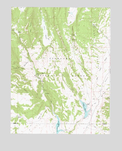
Forsyth Reservoir, UT USGS Topographic Map
Click on map above to begin viewing in our Map Viewer.

This topographic map contains these locations and features:
Feature Name Type Latitude Longitude GNIS ID View Map
Cedarless FlatFlatN38.5180°W111.5877°1439598View Map
Danish MeadowsFlatN38.5994°W111.5824°1440264View Map
Deer SpringSpringN38.5366°W111.5020°1440398View Map
Deer Spring DrawValleyN38.5322°W111.5180°1440401View Map
East Tidwell CanyonValleyN38.5439°W111.5216°1440849View Map
East Tidwell SpringSpringN38.6080°W111.5227°1440850View Map
Forsyth DamDamN38.5166°W111.5324°1447720View Map
Forsyth ReservoirReservoirN38.5251°W111.5317°1441182View Map
Forsyth SpringsSpringN38.5283°W111.5286°1441183View Map
Foy BenchBenchN38.5591°W111.5018°1441204View Map
Ivie CanyonValleyN38.5536°W111.5891°1442073View Map
Mamoits SpringSpringN38.5590°W111.5932°1443120View Map
Mill Meadow ReservoirReservoirN38.5058°W111.5659°1447714View Map
Pah Ga Ne A CampgroundLocaleN38.5397°W111.5813°1444159View Map
Paraboo CampgroundLocaleN38.5519°W111.5877°1444176View Map
Pole CampgroundLocaleN38.5433°W111.5846°1444510View Map
Pole CanyonValleyN38.5389°W111.5855°1444528View Map
Post HollowValleyN38.5225°W111.5716°1449934View Map
Salt GulchValleyN38.5099°W111.5426°1445283View Map
Short CreekStreamN38.5244°W111.5246°1445553View Map
Snow Fence PondLakeN38.5977°W111.5444°1445742View Map
Splatter CanyonValleyN38.5639°W111.5960°1445967View Map
Splatter Drip CanyonValleyN38.5714°W111.6007°1445968View Map
Spring ReservoirReservoirN38.5166°W111.6165°1446053View Map
Tidwell PondLakeN38.6194°W111.5495°1446589View Map
Tidwell SlopesSlopeN38.5925°W111.5143°1446591View Map
Toats CampgroundLocaleN38.5553°W111.5910°1446624View Map
Toats SpringSpringN38.5594°W111.5869°1446625View Map
U M CreekStreamN38.5019°W111.5571°1446824View Map
West Tidwell CanyonValleyN38.5322°W111.5180°1447180View Map
West Tidwell SpringSpringN38.5930°W111.5488°1447181View Map
Zedds CampgroundLocaleN38.6019°W111.6210°1447580View Map
Zedds MeadowsFlatN38.6003°W111.6180°1447581View Map
Zedds MountainSummitN38.6061°W111.6032°1447582View Map

Note: Coordinates in the location and feature list above are referenced to NAD83 datum.


Copyright (C) 2008-2025 Ryan Niemi / Sunset Dynamics ... All Rights Reserved