TopoQuest Logo
Do you find TopoQuest useful?
Help keep TopoQuest running and adding new maps/features by donating!
Bitcoin:  19c7KJd3qBynnjoSw5npx9KScwjBe4ifkT
Litecoin:  LXs6TkuXGGXo1vDsWCkWVdjQX94eUKd6ui
Home View Maps Find Maps Find Places Resources & Links


Ballston, Oregon Topographic Map

USGS Map Title: Ballston, OR
USGS Map MRC: 45123A3
DRG (GeoTIFF) Download: o45123a3.tif


Neighboring USGS Topographic Map Quads:


  Stony Mountain, OR  
45123B4
 

  Muddy Valley, OR  
45123B3
 

  McMinnville, OR  
45123B2
 

  Sheridan, OR  
45123A4
 

  Ballston, OR  
45123A3
 

  Amity, OR  
45123A2
 

  Socialist Valley, OR  
44123H4
 

  Dallas, OR  
44123H3
 

  Rickreall, OR  
44123H2


Map MRC Location:

N46°
W124°
N46°
W123°
H8 H7 H6 H5 H4 H3 H2 H1
G8 G7 G6 G5 G4 G3 G2 G1
F8 F7 F6 F5 F4 F3 F2 F1
E8 E7 E6 E5 E4 E3 E2 E1
D8 D7 D6 D5 D4 D3 D2 D1
C8 C7 C6 C5 C4 C3 C2 C1
B8 B7 B6 B5 B4 B3 B2 B1
A8 A7 A6 A5 A4 A3 A2 A1
N45°
W124°
N45°
W123°

Ballston, OR USGS 1:24K Topographic Map Preview:
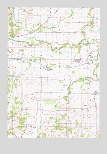
Ballston, OR USGS Topographic Map
Click on map above to begin viewing in our Map Viewer.

This topographic map contains these locations and features:
Feature Name Type Latitude Longitude GNIS ID View Map
Amity Fire District Station 50BuildingN45.0421°W123.2516°2577031View Map
Ball CemeteryCemeteryN45.0722°W123.3280°1162824View Map
BallstonPopulated PlaceN45.0668°W123.3209°1162825View Map
Ballston County ParkParkN45.0675°W123.3226°1157887View Map
Ballston Post Office (historical)Post OfficeN45.0668°W123.3209°1164875View Map
BellevuePopulated PlaceN45.1154°W123.3162°1162838View Map
Bellevue Post Office (historical)Post OfficeN45.1154°W123.3162°1164905View Map
Berkey CreekStreamN45.1207°W123.3679°1163409View Map
Brigittine MonasteryChurchN45.0901°W123.2693°1157888View Map
BroadmeadPopulated PlaceN45.0729°W123.2695°1166622View Map
Broadmead Post Office (historical)Post OfficeN45.0729°W123.2695°1164963View Map
Bruinsma ReservoirReservoirN45.0518°W123.2679°1160789View Map
Buhler ReservoirReservoirN45.0105°W123.3432°1163437View Map
Byerley CornerLocaleN45.0429°W123.3276°1163436View Map
Campbell ReservoirReservoirN45.0533°W123.2857°1163433View Map
Chandler LakeLakeN45.0841°W123.3572°1162891View Map
Deer Creek CemeteryCemeteryN45.1052°W123.3169°1162936View Map
Dejong DamDamN45.0565°W123.3479°1163606View Map
Dejong ReservoirReservoirN45.0574°W123.3491°1130162View Map
Dupee CreekStreamN45.1234°W123.3687°1162953View Map
Eola Hills Charter SchoolSchoolN45.0656°W123.3194°2486905View Map
Fast Reservoir (historical)ReservoirN45.0221°W123.3282°1160785View Map
Green Acres ReservoirReservoirN45.0438°W123.2915°1163435View Map
Harrison (historical)LocaleN45.0915°W123.2540°1163410View Map
Harrison LakeLakeN45.1026°W123.2648°1163412View Map
Hidden Lake ReservoirReservoirN45.0092°W123.2880°1163411View Map
Hoekstre SloughStreamN45.0021°W123.3340°1163052View Map
Ingebrand DamDamN45.0548°W123.2829°1163601View Map
Larson ReservoirReservoirN45.0096°W123.2817°1163438View Map
Lawn Arbor Post Office (historical)Post OfficeN45.0707°W123.2851°1164463View Map
Lillie Walker Irrigation PondReservoirN45.0738°W123.2789°1131587View Map
Lillie Walker Irrigation Pond DamDamN45.0765°W123.2779°1131586View Map
Marvin Fast ReservoirReservoirN45.0121°W123.3477°1639200View Map
Morgan's AirportAirportN45.0662°W123.3277°2770600View Map
Muller ReservoirReservoirN45.0243°W123.3284°1130163View Map
Neighbors ReservoirReservoirN45.0290°W123.3112°1160784View Map
Neuschwanger ReservoirReservoirN45.0483°W123.3736°1163431View Map
PerrydalePopulated PlaceN45.0426°W123.2557°1125312View Map
Perrydale Post Office (historical)Post OfficeN45.0426°W123.2557°1165780View Map
Perrydale SchoolSchoolN45.0417°W123.2572°1166792View Map
Phoenix ReservoirReservoirN45.0296°W123.2993°1160787View Map
Pleasant Hill CemeteryCemeteryN45.0590°W123.3715°1163207View Map
Rossner ReservoirReservoirN45.1042°W123.3064°1130122View Map
Scharf ReservoirReservoirN45.0438°W123.2915°1163434View Map
Sheridan Fire District Substation BallstonBuildingN45.0679°W123.3219°2576750View Map
Sheridan Junction (historical)LocaleN45.0712°W123.2720°1166234View Map
South Yamhill (historical)LocaleN45.0721°W123.2665°1158068View Map
South Yamhill Post Office (historical)Post OfficeN45.0722°W123.2653°1165966View Map
Stapleton ReservoirReservoirN45.0294°W123.2634°1160788View Map
Swearingen ReservoirReservoirN45.0248°W123.2982°1130164View Map
Tellin ReservoirReservoirN45.0083°W123.2799°1163439View Map
Tucker (historical)Populated PlaceN45.0665°W123.2929°1163414View Map
United Brethren CemeteryCemeteryN45.1243°W123.3270°1163368View Map
Wabash (historical)LocaleN45.0762°W123.3568°1163413View Map
Walker DamDamN45.0798°W123.2545°1131583View Map
Walker Dam Number TwoDamN45.0748°W123.2812°1133705View Map
Walker ReservoirReservoirN45.0779°W123.2524°1160790View Map
Walker Reservoir Number TwoReservoirN45.0735°W123.2817°1133706View Map
Washington Post Office (historical)Post OfficeN45.1243°W123.3682°1164771View Map
WinchLocaleN45.0790°W123.2659°1163359View Map

Note: Coordinates in the location and feature list above are referenced to NAD83 datum.


Copyright (C) 2008-2024 Ryan Niemi / Sunset Dynamics ... All Rights Reserved