TopoQuest Logo
Do you find TopoQuest useful?
Help keep TopoQuest running and adding new maps/features by donating!
Bitcoin:  19c7KJd3qBynnjoSw5npx9KScwjBe4ifkT
Litecoin:  LXs6TkuXGGXo1vDsWCkWVdjQX94eUKd6ui
Home View Maps Find Maps Find Places Resources & Links


Ballsville, Virginia Topographic Map

USGS Map Title: Ballsville, VA
USGS Map MRC: 37078D1
DRG (GeoTIFF) Download: o37078d1.tif


Neighboring USGS Topographic Map Quads:


  Whiteville, VA  
37078E2
 

  Trenholm, VA  
37078E1
 

  Powhatan, VA  
37077E8
 

  Cumberland, VA  
37078D2
 

  Ballsville, VA  
37078D1
 

  Chula, VA  
37077D8
 

  Deatonville, VA  
37078C2
 

  Jetersville, VA  
37078C1
 

  Amelia Court House, VA  
37077C8


Map MRC Location:

N38°
W79°
N38°
W78°
H8 H7 H6 H5 H4 H3 H2 H1
G8 G7 G6 G5 G4 G3 G2 G1
F8 F7 F6 F5 F4 F3 F2 F1
E8 E7 E6 E5 E4 E3 E2 E1
D8 D7 D6 D5 D4 D3 D2 D1
C8 C7 C6 C5 C4 C3 C2 C1
B8 B7 B6 B5 B4 B3 B2 B1
A8 A7 A6 A5 A4 A3 A2 A1
N37°
W79°
N37°
W78°

Ballsville, VA USGS 1:24K Topographic Map Preview:
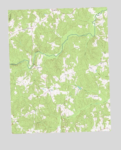
Ballsville, VA USGS Topographic Map
Click on map above to begin viewing in our Map Viewer.

This topographic map contains these locations and features:
Feature Name Type Latitude Longitude GNIS ID View Map
Amelia County Volunteer Fire Department Company 5 PainevilleBuildingN37.3926°W78.1218°2331896View Map
BallsvillePopulated PlaceN37.4985°W78.0669°1462755View Map
Bardens DamDamN37.4185°W78.0364°1489120View Map
Bardens PondReservoirN37.4196°W78.0380°1489121View Map
Bent CreekStreamN37.4407°W78.1006°1463079View Map
Clementown MillsPopulated PlaceN37.4410°W78.0903°1477209View Map
Dolittle CreekStreamN37.4726°W78.0208°1465879View Map
Epworth ChurchChurchN37.4540°W78.0056°1466338View Map
Flower Hill CemeteryCemeteryN37.4243°W78.0164°1497785View Map
Flower Hill ChurchChurchN37.4413°W78.0172°1466737View Map
Haw BranchStreamN37.4046°W78.0047°1467837View Map
Haw BranchPopulated PlaceN37.4104°W78.0206°1493062View Map
Hobsons ChapelChurchN37.4793°W78.1056°1468086View Map
Horsepen CreekStreamN37.3818°W78.0639°1468290View Map
Hunter-Brooks DamDamN37.4818°W78.0681°1490639View Map
Little Bent CreekStreamN37.4402°W78.0992°1469470View Map
Little Union ChurchChurchN37.4204°W78.0778°1484994View Map
Little Union School (historical)SchoolN37.4207°W78.0789°1497794View Map
LodorePopulated PlaceN37.4393°W78.0225°1477496View Map
MorvenPopulated PlaceN37.4182°W78.0756°1477555View Map
PainevillePopulated PlaceN37.3874°W78.1203°1477604View Map
Paineville School (historical)SchoolN37.3860°W78.1239°1497801View Map
Piedmont CemeteryCemeteryN37.4271°W78.0094°1497802View Map
Piedmont ChurchChurchN37.4438°W78.0100°1472276View Map
Powhatan County Fire Department Company 3 - Macon District Volunteer Fire DepartmentBuildingN37.4822°W78.0981°2086089View Map
Powhatan County Volunteer Rescue Squad Substation 2BuildingN37.4985°W78.0639°2086086View Map
Stock CreekStreamN37.4454°W78.1250°1475167View Map
TobaccovillePopulated PlaceN37.4824°W78.0958°1477815View Map
Union ChurchChurchN37.3988°W78.0947°1476050View Map

Note: Coordinates in the location and feature list above are referenced to NAD83 datum.


Copyright (C) 2008-2025 Ryan Niemi / Sunset Dynamics ... All Rights Reserved