TopoQuest Logo
Do you find TopoQuest useful?
Help keep TopoQuest running and adding new maps/features by donating!
Bitcoin:  19c7KJd3qBynnjoSw5npx9KScwjBe4ifkT
Litecoin:  LXs6TkuXGGXo1vDsWCkWVdjQX94eUKd6ui
Home View Maps Find Maps Find Places Resources & Links


Justin, Texas Topographic Map

USGS Map Title: Justin, TX
USGS Map MRC: 33097A3
DRG (GeoTIFF) Download: o33097a3.tif


Neighboring USGS Topographic Map Quads:


  Bluett, TX  
33097B4
 

  Ponder, TX  
33097B3
 

  Denton West, TX  
33097B2
 

  Rhome, TX  
33097A4
 

  Justin, TX  
33097A3
 

  Argyle, TX  
33097A2
 

  Avondale, TX  
32097H4
 

  Keller, TX  
32097H3
 

  Colleyville, TX  
32097H2


Map MRC Location:

N34°
W98°
N34°
W97°
H8 H7 H6 H5 H4 H3 H2 H1
G8 G7 G6 G5 G4 G3 G2 G1
F8 F7 F6 F5 F4 F3 F2 F1
E8 E7 E6 E5 E4 E3 E2 E1
D8 D7 D6 D5 D4 D3 D2 D1
C8 C7 C6 C5 C4 C3 C2 C1
B8 B7 B6 B5 B4 B3 B2 B1
A8 A7 A6 A5 A4 A3 A2 A1
N33°
W98°
N33°
W97°

Justin, TX USGS 1:24K Topographic Map Preview:
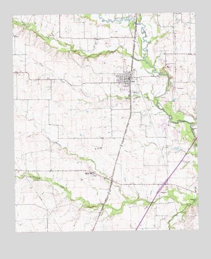
Justin, TX USGS Topographic Map
Click on map above to begin viewing in our Map Viewer.

This topographic map contains these locations and features:
Feature Name Type Latitude Longitude GNIS ID View Map
American Airlines Emergency Response TeamBuildingN33.0057°W97.3164°2655937View Map
Bible Baptist ChurchChurchN33.1118°W97.3242°2018366View Map
Bishop ParkParkN33.0751°W97.2984°1330722View Map
Blue Jay Air Field (historical)AirportN33.0885°W97.2575°1386978View Map
Buchannan LakeReservoirN33.0468°W97.2620°1855453View Map
Buchannan Lake DamDamN33.0468°W97.2620°1855452View Map
City of JustinCivilN33.0862°W97.3009°2410158View Map
City of Justin Wastewater Treatment PlantLocaleN33.0796°W97.2931°2428166View Map
Dooley AirportAirportN33.0901°W97.2683°1386979View Map
ElizabethtownPopulated PlaceN33.0218°W97.2767°1378252View Map
Elizabethtown CemeteryCemeteryN33.0157°W97.2717°1335313View Map
First Baptist ChurchChurchN33.0862°W97.2995°2018319View Map
Flying S Farm AirportAirportN33.0807°W97.3489°1386970View Map
Gene Pike Middle SchoolSchoolN33.0865°W97.2886°2004015View Map
Harriet CreekStreamN33.0168°W97.2984°1337381View Map
Henrietta CreekStreamN33.0140°W97.2581°1337621View Map
Hog BranchStreamN33.1193°W97.2878°1337880View Map
JustinPopulated PlaceN33.0848°W97.2961°1338936View Map
Justin Assembly of God ChurchChurchN33.0862°W97.2997°2018362View Map
Justin Elementary SchoolSchoolN33.0807°W97.3080°2003966View Map
Justin Fire DepartmentBuildingN33.0870°W97.2968°2551762View Map
Justin Methodist ChurchChurchN33.0873°W97.2992°2018212View Map
Justin ParkParkN33.0898°W97.3031°2029092View Map
Justin Police DepartmentBuildingN33.0886°W97.3034°2738902View Map
Justin Post OfficePost OfficeN33.0888°W97.2965°2732008View Map
Justin-Roanoke DivisionCivilN33.0979°W97.2697°1938875View Map
Northwest High SchoolSchoolN33.0332°W97.3231°1342876View Map
Northwest Ninth Grade CenterSchoolN33.0865°W97.2886°2003995View Map
Oliver CreekStreamN33.0979°W97.2853°1343257View Map
Propwash AirportAirportN33.0807°W97.3589°1386972View Map
Sitton FieldAirportN33.1179°W97.3215°1386971View Map
Texan StadiumParkN33.0323°W97.3225°2027676View Map
Texas Motor SpeedwayParkN33.0351°W97.2809°2028129View Map
Texas Motor Speedway Emergency Medical Service Care CenterBuildingN33.0268°W97.2838°2655936View Map
Town of NorthlakeCivilN33.0801°W97.2546°2413055View Map
Trail CreekStreamN33.0704°W97.2764°1348692View Map
W R Hatfield Intermediate SchoolSchoolN33.0862°W97.2886°2003922View Map

Note: Coordinates in the location and feature list above are referenced to NAD83 datum.


Copyright (C) 2008-2024 Ryan Niemi / Sunset Dynamics ... All Rights Reserved