TopoQuest Logo
Do you find TopoQuest useful?
Help keep TopoQuest running and adding new maps/features by donating!
Bitcoin:  19c7KJd3qBynnjoSw5npx9KScwjBe4ifkT
Litecoin:  LXs6TkuXGGXo1vDsWCkWVdjQX94eUKd6ui
Home View Maps Find Maps Find Places Resources & Links


Ponder, Texas Topographic Map

USGS Map Title: Ponder, TX
USGS Map MRC: 33097B3
DRG (GeoTIFF) Download: o33097b3.tif


Neighboring USGS Topographic Map Quads:


  Slidell, TX  
33097C4
 

  Era SE, TX  
33097C3
 

  Sanger, TX  
33097C2
 

  Bluett, TX  
33097B4
 

  Ponder, TX  
33097B3
 

  Denton West, TX  
33097B2
 

  Rhome, TX  
33097A4
 

  Justin, TX  
33097A3
 

  Argyle, TX  
33097A2


Map MRC Location:

N34°
W98°
N34°
W97°
H8 H7 H6 H5 H4 H3 H2 H1
G8 G7 G6 G5 G4 G3 G2 G1
F8 F7 F6 F5 F4 F3 F2 F1
E8 E7 E6 E5 E4 E3 E2 E1
D8 D7 D6 D5 D4 D3 D2 D1
C8 C7 C6 C5 C4 C3 C2 C1
B8 B7 B6 B5 B4 B3 B2 B1
A8 A7 A6 A5 A4 A3 A2 A1
N33°
W98°
N33°
W97°

Ponder, TX USGS 1:24K Topographic Map Preview:
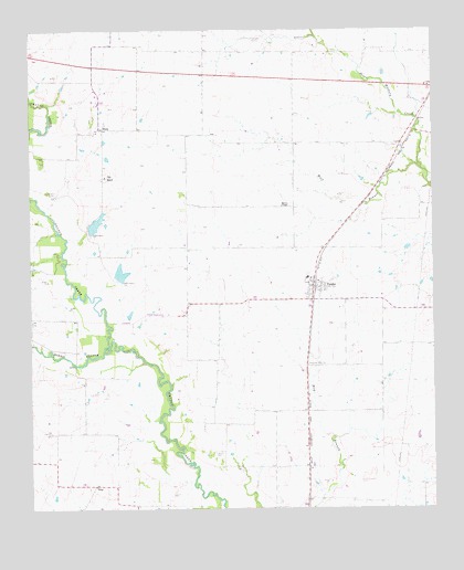
Ponder, TX USGS Topographic Map
Click on map above to begin viewing in our Map Viewer.

This topographic map contains these locations and features:
Feature Name Type Latitude Longitude GNIS ID View Map
Akain CemeteryCemeteryN33.1393°W97.3184°1329287View Map
Brown ChapelChurchN33.2040°W97.2967°1331343View Map
C Hobson Dunn Dam Number 1DamN33.1985°W97.3570°1855456View Map
C Hobson Dunn Dam Number 2DamN33.1851°W97.3486°1855458View Map
C Hobson Dunn Lake Number 1ReservoirN33.1997°W97.3548°1855457View Map
C Hobson Dunn Lake Number 2ReservoirN33.1851°W97.3486°1855459View Map
City of Denton Water Treatment FacilityLocaleN33.1436°W97.2654°2428162View Map
Clark AirportAirportN33.1335°W97.2967°1386974View Map
Crow BranchStreamN33.2485°W97.2861°1333736View Map
Deussen FieldAirportN33.1799°W97.3154°1387336View Map
Dew Drop AirportAirportN33.1296°W97.3609°1386980View Map
DISHPopulated PlaceN33.1329°W97.3014°1926816View Map
DropPopulated PlaceN33.1310°W97.3559°1378230View Map
Drop Field (historical)AirportN33.1251°W97.3464°1386976View Map
Dun RanchLocaleN33.2112°W97.3514°1334761View Map
Flying P AirportAirportN33.1487°W97.3748°2676629View Map
Morris BranchStreamN33.1676°W97.3509°1341932View Map
NorthlakePopulated PlaceN33.1273°W97.2656°1388593View Map
Palmer Field Airport (historical)AirportN33.2035°W97.3145°1387335View Map
PonderPopulated PlaceN33.1829°W97.2872°1344345View Map
Ponder Post OfficePost OfficeN33.1830°W97.2892°2731831View Map
Ponder Volunteer Fire DepartmentBuildingN33.1833°W97.2861°2551489View Map
Prose FieldAirportN33.1464°W97.2802°2676562View Map
Roma AirportAirportN33.1832°W97.2545°2675878View Map
Sagebrush AirportAirportN33.1487°W97.3748°1386975View Map
StonyPopulated PlaceN33.2243°W97.3525°1379120View Map
Stony CemeteryCemeteryN33.2076°W97.3695°1347971View Map
Town of DISHCivilN33.1329°W97.3014°2412433View Map
Town of PonderCivilN33.1776°W97.2909°2412496View Map
Wolf BranchStreamN33.2135°W97.2539°1350455View Map

Note: Coordinates in the location and feature list above are referenced to NAD83 datum.


Copyright (C) 2008-2024 Ryan Niemi / Sunset Dynamics ... All Rights Reserved