TopoQuest Logo
Do you find TopoQuest useful?
Help keep TopoQuest running and adding new maps/features by donating!
Bitcoin:  19c7KJd3qBynnjoSw5npx9KScwjBe4ifkT
Litecoin:  LXs6TkuXGGXo1vDsWCkWVdjQX94eUKd6ui
Home View Maps Find Maps Find Places Resources & Links


Bluett, Texas Topographic Map

USGS Map Title: Bluett, TX
USGS Map MRC: 33097B4
DRG (GeoTIFF) Download: o33097b4.tif


Neighboring USGS Topographic Map Quads:


  Pecan Creek, TX  
33097C5
 

  Slidell, TX  
33097C4
 

  Era SE, TX  
33097C3
 

  Decatur, TX  
33097B5
 

  Bluett, TX  
33097B4
 

  Ponder, TX  
33097B3
 

  Boyd, TX  
33097A5
 

  Rhome, TX  
33097A4
 

  Justin, TX  
33097A3


Map MRC Location:

N34°
W98°
N34°
W97°
H8 H7 H6 H5 H4 H3 H2 H1
G8 G7 G6 G5 G4 G3 G2 G1
F8 F7 F6 F5 F4 F3 F2 F1
E8 E7 E6 E5 E4 E3 E2 E1
D8 D7 D6 D5 D4 D3 D2 D1
C8 C7 C6 C5 C4 C3 C2 C1
B8 B7 B6 B5 B4 B3 B2 B1
A8 A7 A6 A5 A4 A3 A2 A1
N33°
W98°
N33°
W97°

Bluett, TX USGS 1:24K Topographic Map Preview:
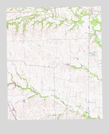
Bluett, TX USGS Topographic Map
Click on map above to begin viewing in our Map Viewer.

This topographic map contains these locations and features:
Feature Name Type Latitude Longitude GNIS ID View Map
Allison Farm AirportAirportN33.2387°W97.4282°2676577View Map
BluettPopulated PlaceN33.1576°W97.4384°1378022View Map
Burns BranchStreamN33.2398°W97.3892°1383049View Map
Catlett CreekStreamN33.2390°W97.4395°1383059View Map
Corinth ChurchChurchN33.1840°W97.4464°1333367View Map
Deussen Reservoir DamDamN33.1968°W97.3853°1855454View Map
Duessen ReservoirReservoirN33.1995°W97.3842°1334726View Map
East Wise Fire and RescueBuildingN33.1578°W97.4395°2551708View Map
Elna ReservoirReservoirN33.1368°W97.4920°1857145View Map
Elna Reservoir DamDamN33.1368°W97.4920°1857144View Map
Hackberry CreekStreamN33.1362°W97.4145°1337190View Map
Heritage Creek AirstripAirportN33.1687°W97.4842°1386524View Map
Long BranchStreamN33.1601°W97.4747°1340440View Map
Phoenix Medical ServiceBuildingN33.1536°W97.4400°2656164View Map
Rhome Meadows AirportAirportN33.1500°W97.4977°1387389View Map
Soil Conservation Service Site 24b DamDamN33.2351°W97.4536°1857148View Map
Soil Conservation Service Site 24b ReservoirReservoirN33.2351°W97.4536°1857149View Map
Soil Conservation Service Site 25a DamDamN33.2251°W97.4136°1857150View Map
Soil Conservation Service Site 25a ReservoirReservoirN33.2251°W97.4136°1857151View Map
Soil Conservation Service Site 26 DamDamN33.1851°W97.4186°1857146View Map
Soil Conservation Service Site 26 ReservoirReservoirN33.1851°W97.4186°1857147View Map
Soil Conservation Service Site 27a DamDamN33.1918°W97.4070°1857152View Map
Soil Conservation Service Site 27a ReservoirReservoirN33.1918°W97.4070°1857153View Map
Soil Conservation Service Site 29 DamDamN33.1635°W97.4886°1857154View Map
Soil Conservation Service Site 29 ReservoirReservoirN33.1635°W97.4886°1857155View Map
Soil Conservation Service Site 30 DamDamN33.1735°W97.4836°1857156View Map
Soil Conservation Service Site 30 ReservoirReservoirN33.1735°W97.4836°1857157View Map
Soil Conservation Service Site 31 DamDamN33.1468°W97.4770°1857158View Map
Soil Conservation Service Site 31 ReservoirReservoirN33.1468°W97.4770°1857159View Map
South Fork Hackberry CreekStreamN33.1307°W97.4325°1347447View Map
Sweetwater ChurchChurchN33.2462°W97.4820°1348141View Map
Sweetwater CreekStreamN33.2398°W97.4028°1348144View Map
Teeter BranchStreamN33.1543°W97.4592°1348327View Map

Note: Coordinates in the location and feature list above are referenced to NAD83 datum.


Copyright (C) 2008-2024 Ryan Niemi / Sunset Dynamics ... All Rights Reserved