TopoQuest Logo
Do you find TopoQuest useful?
Help keep TopoQuest running and adding new maps/features by donating!
Bitcoin:  19c7KJd3qBynnjoSw5npx9KScwjBe4ifkT
Litecoin:  LXs6TkuXGGXo1vDsWCkWVdjQX94eUKd6ui
Home View Maps Find Maps Find Places Resources & Links


Bancos Mesa, New Mexico Topographic Map

USGS Map Title: Bancos Mesa, NM
USGS Map MRC: 36107H3
DRG (GeoTIFF) Download: o36107h3.tif


Neighboring USGS Topographic Map Quads:


  Allison, CO  
37107A4
 

  Carracas, CO  
37107A3
 

  Pagosa Junction, CO  
37107A2
 

  Bancos Mesa NW, NM  
36107H4
 

  Bancos Mesa, NM  
36107H3
 

  Carracas Canyon, NM  
36107H2
 

  Gomez Ranch, NM  
36107G4
 

  Espinosa Ranch, NM  
36107G3
 

  Bixler Ranch, NM  
36107G2


Map MRC Location:

N37°
W108°
N37°
W107°
H8 H7 H6 H5 H4 H3 H2 H1
G8 G7 G6 G5 G4 G3 G2 G1
F8 F7 F6 F5 F4 F3 F2 F1
E8 E7 E6 E5 E4 E3 E2 E1
D8 D7 D6 D5 D4 D3 D2 D1
C8 C7 C6 C5 C4 C3 C2 C1
B8 B7 B6 B5 B4 B3 B2 B1
A8 A7 A6 A5 A4 A3 A2 A1
N36°
W108°
N36°
W107°

Bancos Mesa, NM USGS 1:24K Topographic Map Preview:
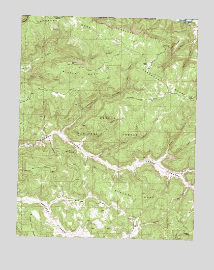
Bancos Mesa, NM USGS Topographic Map
Click on map above to begin viewing in our Map Viewer.

This topographic map contains these locations and features:
Feature Name Type Latitude Longitude GNIS ID View Map
Alamo CanyonValleyN36.9600°W107.3003°903039View Map
Alamo TankReservoirN36.9712°W107.3152°2678812View Map
Anselmo BenchBenchN36.9156°W107.3592°903175View Map
Bancos MesaSummitN36.9006°W107.2870°903533View Map
Box TankReservoirN36.9895°W107.3198°904046View Map
Caņon CedroValleyN36.9231°W107.2706°904634View Map
Caņon PintadoValleyN36.9181°W107.2781°904681View Map
Carracas CemeteryCemeteryN36.9997°W107.2500°904789View Map
Carracas MesaSummitN36.9999°W107.3414°904791View Map
Carracas RimCliffN36.9908°W107.2942°904792View Map
Cedar RockSummitN36.9556°W107.2531°904874View Map
Chavez TankReservoirN36.9739°W107.2862°905062View Map
Cottonwood CanyonValleyN36.9331°W107.3475°905405View Map
Devils CanyonValleyN36.9883°W107.2520°905730View Map
Eul PointCapeN36.9925°W107.3537°906204View Map
Eula CanyonValleyN36.9203°W107.3217°906205View Map
Gurule CanyonValleyN36.9106°W107.2645°906783View Map
Horse TankReservoirN36.9861°W107.3064°907113View Map
Log TankReservoirN36.9986°W107.3478°908121View Map
Martinez CanyonValleyN36.8922°W107.3564°908436View Map
Middle MesaSummitN36.9714°W107.3309°908706View Map
Orcones CanyonValleyN36.9267°W107.3342°909360View Map
Pecho de la DoncellaSummitN36.9233°W107.3403°909529View Map
Peters CanyonValleyN36.9311°W107.3573°909589View Map
Quintana MesaSummitN36.9536°W107.3731°909942View Map
Rincon QuemadoValleyN36.9308°W107.3542°910204View Map
Saltero CanyonValleyN36.9689°W107.3739°910578View Map
Sanchez TankReservoirN36.8828°W107.3189°2678811View Map
Velasquez SpringSpringN36.8783°W107.2539°912090View Map
Wild Horse CanyonValleyN36.9058°W107.2548°912372View Map

Note: Coordinates in the location and feature list above are referenced to NAD83 datum.


Copyright (C) 2008-2025 Ryan Niemi / Sunset Dynamics ... All Rights Reserved