TopoQuest Logo
Do you find TopoQuest useful?
Help keep TopoQuest running and adding new maps/features by donating!
Bitcoin:  19c7KJd3qBynnjoSw5npx9KScwjBe4ifkT
Litecoin:  LXs6TkuXGGXo1vDsWCkWVdjQX94eUKd6ui
Home View Maps Find Maps Find Places Resources & Links


Bixler Ranch, New Mexico Topographic Map

USGS Map Title: Bixler Ranch, NM
USGS Map MRC: 36107G2
DRG (GeoTIFF) Download: o36107g2.tif


Neighboring USGS Topographic Map Quads:


  Bancos Mesa, NM  
36107H3
 

  Carracas Canyon, NM  
36107H2
 

  Wirt Canyon, NM  
36107H1
 

  Espinosa Ranch, NM  
36107G3
 

  Bixler Ranch, NM  
36107G2
 

  John Mills Lake, NM  
36107G1
 

  Gobernador, NM  
36107F3
 

  Leandro Canyon, NM  
36107F2
 

  Cement Lake, NM  
36107F1


Map MRC Location:

N37°
W108°
N37°
W107°
H8 H7 H6 H5 H4 H3 H2 H1
G8 G7 G6 G5 G4 G3 G2 G1
F8 F7 F6 F5 F4 F3 F2 F1
E8 E7 E6 E5 E4 E3 E2 E1
D8 D7 D6 D5 D4 D3 D2 D1
C8 C7 C6 C5 C4 C3 C2 C1
B8 B7 B6 B5 B4 B3 B2 B1
A8 A7 A6 A5 A4 A3 A2 A1
N36°
W108°
N36°
W107°

Bixler Ranch, NM USGS 1:24K Topographic Map Preview:
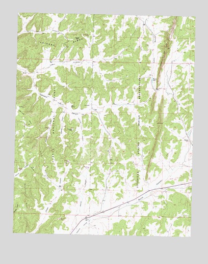
Bixler Ranch, NM USGS Topographic Map
Click on map above to begin viewing in our Map Viewer.

This topographic map contains these locations and features:
Feature Name Type Latitude Longitude GNIS ID View Map
Augustine CanyonValleyN36.8208°W107.2237°903460View Map
Augustine TankReservoirN36.8097°W107.2258°2678794View Map
Bancos LakeReservoirN36.8386°W107.1550°903532View Map
Bixler RanchLocaleN36.7764°W107.2175°903848View Map
Burns CanyonValleyN36.7606°W107.1878°904211View Map
Burns Canyon Water WellWellN36.7614°W107.1762°926503View Map
Caberesto Water WellWellN36.7867°W107.1792°926492View Map
Calvin Veneno Water WellWellN36.8039°W107.1262°926494View Map
Caņon ChicosaValleyN36.8411°W107.2381°904640View Map
Chicosa RidgeRidgeN36.8539°W107.2406°905090View Map
Chicosa TankReservoirN36.8603°W107.2087°912574View Map
Espinosa CanyonValleyN36.8172°W107.2081°906193View Map
Farm C-142 Water WellWellN36.8233°W107.1709°926496View Map
Hole-in-the-Rock-DikeRidgeN36.8567°W107.1448°907025View Map
Lynch RanchLocaleN36.8231°W107.1987°908328View Map
Maestas CanyonValleyN36.8206°W107.2159°908347View Map
Manuel TankReservoirN36.7861°W107.2447°2678792View Map
Marcial CanyonValleyN36.7550°W107.2062°908409View Map
Marcial TankReservoirN36.7882°W107.1986°2678791View Map
Marcial TankReservoirN36.7586°W107.2178°2705899View Map
Mud SpringSpringN36.8225°W107.2117°908949View Map
Preacher TankReservoirN36.8092°W107.2102°909844View Map
Reseeding TankReservoirN36.7913°W107.2122°2678793View Map
Rincon TankReservoirN36.8628°W107.2006°2678795View Map
San Juan BasinBasinN36.8031°W107.2375°913447View Map
San Juan Basin Historical MarkerParkN36.8031°W107.2375°932798View Map
Vanqueras Post Office (historical)Post OfficeN36.7589°W107.1998°938389View Map
Vaqueros (historical)Populated PlaceN36.7589°W107.1998°901530View Map
Vaqueros CabinLocaleN36.7589°W107.1998°912076View Map
Vaqueros Cabin Water WellWellN36.7592°W107.1998°926502View Map

Note: Coordinates in the location and feature list above are referenced to NAD83 datum.


Copyright (C) 2008-2025 Ryan Niemi / Sunset Dynamics ... All Rights Reserved