TopoQuest Logo
Do you find TopoQuest useful?
Help keep TopoQuest running and adding new maps/features by donating!
Bitcoin:  19c7KJd3qBynnjoSw5npx9KScwjBe4ifkT
Litecoin:  LXs6TkuXGGXo1vDsWCkWVdjQX94eUKd6ui
Home View Maps Find Maps Find Places Resources & Links


Bancroft, West Virginia Topographic Map

USGS Map Title: Bancroft, WV
USGS Map MRC: 38081E7
DRG (GeoTIFF) Download: o38081e7.tif


Neighboring USGS Topographic Map Quads:


  Robertsburg, WV  
38081F8
 

  Elmwood, WV  
38081F7
 

  Kenna, WV  
38081F6
 

  Winfield, WV  
38081E8
 

  Bancroft, WV  
38081E7
 

  Sissonville, WV  
38081E6
 

  Scott Depot, WV  
38081D8
 

  Saint Albans, WV  
38081D7
 

  Pocatalico, WV  
38081D6


Map MRC Location:

N39°
W82°
N39°
W81°
H8 H7 H6 H5 H4 H3 H2 H1
G8 G7 G6 G5 G4 G3 G2 G1
F8 F7 F6 F5 F4 F3 F2 F1
E8 E7 E6 E5 E4 E3 E2 E1
D8 D7 D6 D5 D4 D3 D2 D1
C8 C7 C6 C5 C4 C3 C2 C1
B8 B7 B6 B5 B4 B3 B2 B1
A8 A7 A6 A5 A4 A3 A2 A1
N38°
W82°
N38°
W81°

Bancroft, WV USGS 1:24K Topographic Map Preview:
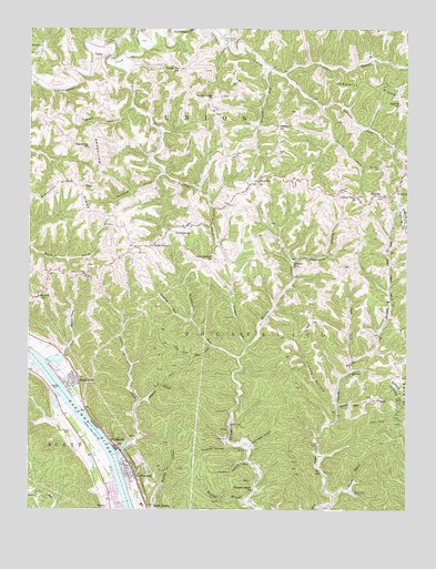
Bancroft, WV USGS Topographic Map
Click on map above to begin viewing in our Map Viewer.

This topographic map contains these locations and features:
Feature Name Type Latitude Longitude GNIS ID View Map
Alcocks HollowValleyN38.5168°W81.8090°1534853View Map
Amherst/Plymouth Wildlife Management AreaParkN38.5376°W81.8232°2043495View Map
Antioch CemeteryCemeteryN38.5657°W81.8141°2586173View Map
Arnie Craigo SpringSpringN38.5523°W81.7937°1678232View Map
Arnold Hoffman SpringSpringN38.5718°W81.8471°1678224View Map
BancroftPopulated PlaceN38.5095°W81.8399°1535197View Map
Bancroft Post OfficePost OfficeN38.5085°W81.8390°1740648View Map
Bancroft Town HallBuildingN38.5087°W81.8424°1740649View Map
Bancroft Volunteer Fire DepartmentBuildingN38.5087°W81.8426°2577644View Map
Beechlick RunStreamN38.5393°W81.8054°1535563View Map
Bigger BranchStreamN38.5037°W81.7737°1535990View Map
Bowles CemeteryCemeteryN38.6215°W81.8082°1536263View Map
Bowles Ridge ChurchChurchN38.6065°W81.8157°1536264View Map
Bowles Ridge Church CemeteryCemeteryN38.6071°W81.8121°2586326View Map
Bowles SpringSpringN38.6023°W81.8126°1678206View Map
Bronco Junction Asthmatic CampLocaleN38.5915°W81.8351°1740656View Map
Bucklick CreekStreamN38.5879°W81.8304°1536609View Map
Cartwright CemeteryCemeteryN38.5017°W81.8024°2586328View Map
Casto SpringSpringN38.5698°W81.8387°1678227View Map
Center Point CemeteryCemeteryN38.5821°W81.7665°2586137View Map
Center Point ChurchChurchN38.5812°W81.7668°1537156View Map
Charles Castro SpringSpringN38.5890°W81.8615°1678208View Map
Charles Castro SpringSpringN38.5840°W81.8596°1678213View Map
Charles Hoffman SpringSpringN38.5756°W81.8451°1678222View Map
Clear ForkStreamN38.5390°W81.7679°1537390View Map
ConfidencePopulated PlaceN38.5726°W81.8287°1554182View Map
Confidence Elementary SchoolSchoolN38.5812°W81.7765°1740673View Map
Crown Hill School (historical)SchoolN38.6140°W81.8249°1537882View Map
ExtraPopulated PlaceN38.6173°W81.8515°1554425View Map
Grandview CemeteryCemeteryN38.5938°W81.8543°2586172View Map
Grandview ChurchChurchN38.5934°W81.8551°1539573View Map
Grandview RidgeRidgeN38.5848°W81.8532°1539576View Map
Guano CreekStreamN38.5145°W81.8457°1539777View Map
Gumlick RunStreamN38.5490°W81.8210°1539791View Map
Hedrick BranchStreamN38.5279°W81.8385°1540123View Map
HeizerPopulated PlaceN38.5359°W81.7685°1554678View Map
Henson SpringSpringN38.6223°W81.8710°1678197View Map
Hoffman SpringSpringN38.5779°W81.8474°1678219View Map
Holiday ParkParkN38.5306°W81.8665°1540383View Map
Homer Bateman SpringSpringN38.5034°W81.8521°1678234View Map
HometownPopulated PlaceN38.5329°W81.8612°1554730View Map
Hometown Census Designated PlaceCensusN38.5288°W81.8552°2586829View Map
Hometown Elementary SchoolSchoolN38.5363°W81.8620°1740705View Map
Hometown Post OfficePost OfficeN38.5335°W81.8592°1740706View Map
Hooten SpringSpringN38.6051°W81.8040°1678203View Map
HugoPopulated PlaceN38.5837°W81.8574°1554757View Map
John Henson SpringSpringN38.6223°W81.8543°1678198View Map
Johnson Shoal LightBuildingN38.5501°W81.8665°1848417View Map
Lincoln School (historical)SchoolN38.5631°W81.7874°1541990View Map
Lindsey BranchStreamN38.5009°W81.7751°1541997View Map
Little Guano CreekStreamN38.5384°W81.8693°1542110View Map
Lone Oak ChurchChurchN38.5559°W81.8701°1542326View Map
Long HollowValleyN38.5276°W81.7737°1542376View Map
Lowgap ForkStreamN38.5426°W81.8026°1542593View Map
Martins BranchStreamN38.5018°W81.8018°1542821View Map
Maxil Fisher SpringSpringN38.5856°W81.7849°1678209View Map
Maxil Fisher SpringSpringN38.5845°W81.7890°1678212View Map
New Antioch ChurchChurchN38.5651°W81.8132°1544105View Map
Oklahoma School (historical)SchoolN38.5998°W81.7924°1544342View Map
Old Antioch CemeteryCemeteryN38.5712°W81.8010°1544345View Map
Painters BranchStreamN38.6131°W81.7907°1544530View Map
ParadisePopulated PlaceN38.5848°W81.7999°1544568View Map
Paul Crago SpringSpringN38.5976°W81.7935°1678207View Map
Pleasant Grove ChurchChurchN38.5051°W81.8010°1544985View Map
PlymouthPopulated PlaceN38.5159°W81.8449°1545078View Map
Pocatalico DistrictCivilN38.5108°W81.7927°1928340View Map
Red House Post OfficePost OfficeN38.5456°W81.8747°1740779View Map
Right Fork Eighteenmile CreekStreamN38.6154°W81.8487°1545638View Map
Robert Parkins SpringSpringN38.5845°W81.7904°1678210View Map
Route 34 Volunteer Fire DepartmentBuildingN38.5685°W81.8401°2577576View Map
Saltlick CreekStreamN38.5879°W81.8304°1546314View Map
Sandhill RidgeRidgeN38.6095°W81.7596°1546385View Map
Sandhill School (historical)SchoolN38.6056°W81.7524°1534774View Map
Scott CemeteryCemeteryN38.5929°W81.7926°1546515View Map
Second BranchStreamN38.5012°W81.8435°1546543View Map
Shank SpringSpringN38.5762°W81.8401°1678220View Map
Shank SpringSpringN38.5695°W81.8418°1678228View Map
Shawnee EstatesPopulated PlaceN38.5043°W81.8465°1740795View Map
Showen CemeteryCemeteryN38.5120°W81.8370°2586320View Map
SigmanPopulated PlaceN38.5818°W81.7590°1546770View Map
Sigman ForkStreamN38.6054°W81.7787°1546772View Map
Slab HollowValleyN38.6045°W81.8415°1546893View Map
Spanish Oak BranchStreamN38.5273°W81.7729°1547102View Map
Spring Valley BranchStreamN38.6204°W81.8387°1547217View Map
Stowers SpringSpringN38.5587°W81.7657°1678229View Map
Stowers SpringSpringN38.5581°W81.7660°1678230View Map
Stowers SpringSpringN38.5568°W81.7696°1678231View Map
Stumpy RunStreamN38.6151°W81.7960°1547602View Map
Sulphur HollowValleyN38.5129°W81.8032°1547713View Map
Sycamore BranchStreamN38.5643°W81.7879°1547819View Map
Thornhill AdditionPopulated PlaceN38.5056°W81.8410°1740815View Map
Tom Lick RunStreamN38.5426°W81.8140°1548119View Map
Town of BancroftCivilN38.5106°W81.8417°2390711View Map
Wade ChapelChurchN38.5684°W81.8340°1548697View Map
Wade Chapel CemeteryCemeteryN38.5682°W81.8334°2586205View Map
Walter Hoffman SpringSpringN38.5806°W81.8240°1678217View Map
Walter Hoffman SpringSpringN38.5801°W81.8168°1678218View Map
Walter Hoffman SpringSpringN38.5762°W81.8171°1678221View Map
Washington HollowValleyN38.5168°W81.8007°1548819View Map
Webb LandingLocaleN38.5168°W81.8499°1848413View Map
Webb Landing Post LightBuildingN38.5167°W81.8500°2702553View Map
Winfield Church of ChristChurchN38.5351°W81.8718°1740828View Map
Winfield WayPopulated PlaceN38.5370°W81.8740°1740834View Map
Witt SpringSpringN38.5812°W81.8390°1678216View Map

Note: Coordinates in the location and feature list above are referenced to NAD83 datum.


Copyright (C) 2008-2024 Ryan Niemi / Sunset Dynamics ... All Rights Reserved