TopoQuest Logo
Do you find TopoQuest useful?
Help keep TopoQuest running and adding new maps/features by donating!
Bitcoin:  19c7KJd3qBynnjoSw5npx9KScwjBe4ifkT
Litecoin:  LXs6TkuXGGXo1vDsWCkWVdjQX94eUKd6ui
Home View Maps Find Maps Find Places Resources & Links


Buffalo, Texas Topographic Map

USGS Map Title: Buffalo, TX
USGS Map MRC: 31096D1
DRG (GeoTIFF) Download: o31096d1.tif


Neighboring USGS Topographic Map Quads:


  Dew, TX  
31096E2
 

  Lanely, TX  
31096E1
 

  Keechi, TX  
31095E8
 

  Donie, TX  
31096D2
 

  Buffalo, TX  
31096D1
 

  Flo, TX  
31095D8
 

  Jewett, TX  
31096C2
 

  Robbins, TX  
31096C1
 

  Centerville, TX  
31095C8


Map MRC Location:

N32°
W97°
N32°
W96°
H8 H7 H6 H5 H4 H3 H2 H1
G8 G7 G6 G5 G4 G3 G2 G1
F8 F7 F6 F5 F4 F3 F2 F1
E8 E7 E6 E5 E4 E3 E2 E1
D8 D7 D6 D5 D4 D3 D2 D1
C8 C7 C6 C5 C4 C3 C2 C1
B8 B7 B6 B5 B4 B3 B2 B1
A8 A7 A6 A5 A4 A3 A2 A1
N31°
W97°
N31°
W96°

Buffalo, TX USGS 1:24K Topographic Map Preview:
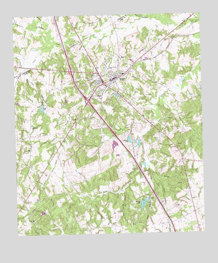
Buffalo, TX USGS Topographic Map
Click on map above to begin viewing in our Map Viewer.

This topographic map contains these locations and features:
Feature Name Type Latitude Longitude GNIS ID View Map
Alligator CreekStreamN31.4835°W96.0961°1351014View Map
Bennett SchoolSchoolN31.4760°W96.0527°1351891View Map
Bow BranchStreamN31.4716°W96.1186°1352729View Map
Browns CreekStreamN31.4991°W96.0380°1372747View Map
BuffaloPopulated PlaceN31.4638°W96.0580°1353185View Map
Buffalo City HallBuildingN31.4648°W96.0578°2753374View Map
Buffalo DivisionCivilN31.4183°W96.0400°1938577View Map
Buffalo Police DepartmentBuildingN31.4645°W96.0584°2739215View Map
Buffalo Post OfficePost OfficeN31.4645°W96.0585°2731872View Map
Buffalo Volunteer Fire DepartmentBuildingN31.4636°W96.0616°2552319View Map
Cain LakeReservoirN31.4545°W96.0572°1864215View Map
Cain Lake DamDamN31.4535°W96.0552°1864214View Map
Cane BranchStreamN31.4863°W96.0683°1353722View Map
Cedar CreekStreamN31.4738°W96.1125°1354059View Map
Cedar Creek ChurchChurchN31.4510°W96.1055°1354083View Map
Cedar Grove ChurchChurchN31.4363°W96.1136°1354097View Map
City of BuffaloCivilN31.4600°W96.0661°2409933View Map
Copper CreekStreamN31.4330°W96.0389°1354969View Map
Davis ChapelChurchN31.4238°W96.1152°1355699View Map
Days LakeLakeN31.4474°W96.1069°1355737View Map
Days LakeReservoirN31.4502°W96.1052°1859081View Map
Graham CemeteryCemeteryN31.4118°W96.0480°1358245View Map
Harcrow Dam Number 1DamN31.4302°W96.0486°1859072View Map
Harcrow LakeReservoirN31.4287°W96.0491°1859073View Map
Harcrow Lake Number 2ReservoirN31.4262°W96.0434°1859075View Map
Harcrow Lake Number 2 DamDamN31.4285°W96.0419°1859074View Map
Haw BranchStreamN31.4157°W96.0389°1358902View Map
Heil LakeReservoirN31.4262°W96.0590°1859079View Map
Heil Lake DamDamN31.4268°W96.0586°1859078View Map
Nettles CemeteryCemeteryN31.4038°W96.0389°1363673View Map
Raines DamDamN31.3952°W96.0369°1859076View Map
Red Oak BranchStreamN31.3996°W96.0544°1366190View Map
Red Oak LakeReservoirN31.3919°W96.0409°1366200View Map
Rena BranchStreamN31.4660°W96.1227°1366340View Map
Right BranchStreamN31.4055°W96.0311°1366459View Map
Russell ChurchChurchN31.3830°W96.1152°1367033View Map
Sand Hill CemeteryCemeteryN31.4413°W96.0752°1367602View Map
Smith BranchStreamN31.4082°W96.0327°1368459View Map
Whitaker DamDamN31.4502°W96.1052°1859080View Map
Whitney BranchStreamN31.4930°W96.1055°1372217View Map

Note: Coordinates in the location and feature list above are referenced to NAD83 datum.


Copyright (C) 2008-2025 Ryan Niemi / Sunset Dynamics ... All Rights Reserved