TopoQuest Logo
Do you find TopoQuest useful?
Help keep TopoQuest running and adding new maps/features by donating!
Bitcoin:  19c7KJd3qBynnjoSw5npx9KScwjBe4ifkT
Litecoin:  LXs6TkuXGGXo1vDsWCkWVdjQX94eUKd6ui
Home View Maps Find Maps Find Places Resources & Links


Nickajack Gap, Georgia Topographic Map

USGS Map Title: Nickajack Gap, GA
USGS Map MRC: 34085G2
DRG (GeoTIFF) Download: o34085g2.tif


Neighboring USGS Topographic Map Quads:


  Fort Oglethorpe, GA  
34085H3
 

  East Ridge, TN  
34085H2
 

  Ringgold, GA  
34085H1
 

  Kensington, GA  
34085G3
 

  Nickajack Gap, GA  
34085G2
 

  Tunnel Hill, GA  
34085G1
 

  LaFayette, GA  
34085F3
 

  Catlett, GA  
34085F2
 

  Villanow, GA  
34085F1


Map MRC Location:

N35°
W86°
N35°
W85°
H8 H7 H6 H5 H4 H3 H2 H1
G8 G7 G6 G5 G4 G3 G2 G1
F8 F7 F6 F5 F4 F3 F2 F1
E8 E7 E6 E5 E4 E3 E2 E1
D8 D7 D6 D5 D4 D3 D2 D1
C8 C7 C6 C5 C4 C3 C2 C1
B8 B7 B6 B5 B4 B3 B2 B1
A8 A7 A6 A5 A4 A3 A2 A1
N34°
W86°
N34°
W85°

Nickajack Gap, GA USGS 1:24K Topographic Map Preview:
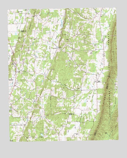
Nickajack Gap, GA USGS Topographic Map
Click on map above to begin viewing in our Map Viewer.

This topographic map contains these locations and features:
Feature Name Type Latitude Longitude GNIS ID View Map
Alice M Daley Adventist SchoolSchoolN34.7812°W85.2142°2545517View Map
Beaumont MountainSummitN34.8445°W85.1880°353211View Map
BeaumountPopulated PlaceN34.8381°W85.1919°331118View Map
Belmont MountainSummitN34.8292°W85.1938°353214View Map
Bethel ChurchChurchN34.7654°W85.2322°354629View Map
Bethel ChurchChurchN34.8051°W85.1497°354631View Map
Bethesda ChurchChurchN34.7590°W85.1577°353958View Map
Blessed Hope MissionChurchN34.8065°W85.2272°353962View Map
Blue Spring Church (historical)ChurchN34.8715°W85.2363°353215View Map
Catoosa County Fire Department Station 2BuildingN34.8052°W85.1485°2604373View Map
Center GrovePopulated PlaceN34.7890°W85.2194°353981View Map
Center Grove ChurchChurchN34.7879°W85.2191°355079View Map
Coulter CreekStreamN34.8026°W85.1586°355330View Map
Dedmon CemeteryCemeteryN34.8348°W85.1272°353242View Map
Freetown (historical)Populated PlaceN34.8134°W85.2416°354049View Map
Gordon SpringSpringN34.7570°W85.1380°356057View Map
Gordon Springs (historical)Populated PlaceN34.7556°W85.1372°353427View Map
Grace ChurchChurchN34.8029°W85.2427°330882View Map
Houston Valley ORV AreaParkN34.7756°W85.1252°330676View Map
Howard Lake DamDamN34.7517°W85.2500°337090View Map
Jackson LakeReservoirN34.8617°W85.1883°337077View Map
Jackson Lake DamDamN34.8617°W85.1883°337076View Map
Lees Mill (historical)LocaleN34.8431°W85.1994°353288View Map
Leet SpringSpringN34.8379°W85.1916°351633View Map
Long HollowValleyN34.8228°W85.2405°328634View Map
McGregor SpringSpringN34.8481°W85.2380°330899View Map
McIntyre CemeteryCemeteryN34.7642°W85.1874°328747View Map
Moon-Jones CemeteryCemeteryN34.7551°W85.1588°328833View Map
Morton Memorial ChurchChurchN34.8723°W85.2380°328847View Map
Mount PisgahPopulated PlaceN34.8459°W85.1791°353292View Map
Mount Pisgah ChurchChurchN34.8448°W85.1797°328886View Map
Mount Pisgah School (historical)SchoolN34.8442°W85.1797°353293View Map
Napier GapGapN34.8687°W85.2180°330900View Map
New Hope ChurchChurchN34.7801°W85.2500°329008View Map
Nickajack GapGapN34.8101°W85.1333°329033View Map
Northwestern Technical CollegeSchoolN34.8093°W85.2463°330140View Map
Pea Vine Academy (historical)SchoolN34.8470°W85.2216°354161View Map
Peavine CemeteryCemeteryN34.8456°W85.2205°354162View Map
Peavine ChurchChurchN34.8465°W85.2208°329156View Map
Peavine RidgeRidgeN34.8045°W85.2047°329158View Map
Red Fox LakeReservoirN34.7558°W85.2126°339618View Map
Red Fox Lake DamDamN34.7542°W85.2113°337092View Map
Rock SpringPopulated PlaceN34.8242°W85.2427°329472View Map
Rock Spring CemeteryCemeteryN34.8159°W85.2355°354181View Map
Rock Spring CreekStreamN34.8112°W85.2180°329474View Map
Rock Spring DivisionCivilN34.8083°W85.2385°1936506View Map
Rock Spring Elementary SchoolSchoolN34.8153°W85.2381°329475View Map
Rock Spring Post OfficePost OfficeN34.8203°W85.2415°354182View Map
Rock Spring United Methodist ChurchChurchN34.8167°W85.2361°354183View Map
Tomlinson ChurchChurchN34.7567°W85.1741°330019View Map
Twin Forks AirportAirportN34.8740°W85.2500°2770507View Map
Walker County Emergency Services Fire Station 1BuildingN34.8095°W85.2421°2603564View Map
Walker County Emergency Services Fire Station 3BuildingN34.7638°W85.1996°2604722View Map
Whaley LakeReservoirN34.7815°W85.2482°354228View Map
Williams Lake DamDamN34.7551°W85.2116°339617View Map
Wilson AirportAirportN34.8692°W85.1998°2717253View Map
Wood StationLocaleN34.8048°W85.1488°330356View Map
Wood Station CemeteryCemeteryN34.7756°W85.1844°330880View Map
Wood Station ValleyValleyN34.8567°W85.1394°330357View Map
Woodstation Elementary SchoolSchoolN34.7776°W85.1610°2545778View Map
Woodstation School (historical)SchoolN34.8048°W85.1494°353354View Map
Yates CemeteryCemeteryN34.8392°W85.1491°330394View Map
Yates SpringSpringN34.8329°W85.1533°330395View Map
Yates Spring ChurchChurchN34.8359°W85.1416°353356View Map
Zion ChurchChurchN34.7992°W85.1875°330881View Map

Note: Coordinates in the location and feature list above are referenced to NAD83 datum.


Copyright (C) 2008-2024 Ryan Niemi / Sunset Dynamics ... All Rights Reserved