TopoQuest Logo
Do you find TopoQuest useful?
Help keep TopoQuest running and adding new maps/features by donating!
Bitcoin:  19c7KJd3qBynnjoSw5npx9KScwjBe4ifkT
Litecoin:  LXs6TkuXGGXo1vDsWCkWVdjQX94eUKd6ui
Home View Maps Find Maps Find Places Resources & Links


Kettle Falls, Washington Topographic Map

USGS Map Title: Kettle Falls, WA
USGS Map MRC: 48118E1
DRG (GeoTIFF) Download: o48118e1.tif


Neighboring USGS Topographic Map Quads:


  Boyds, WA  
48118F2
 

  Marcus, WA  
48118F1
 

  Echo Valley, WA  
48117F8
 

  Bangs Mountain, WA  
48118E2
 

  Kettle Falls, WA  
48118E1
 

  Colville, WA  
48117E8
 

  Rice, WA  
48118D2
 

  Kentry Ridge, WA  
48118D1
 

  Arden, WA  
48117D8


Map MRC Location:

N49°
W119°
N49°
W118°
H8 H7 H6 H5 H4 H3 H2 H1
G8 G7 G6 G5 G4 G3 G2 G1
F8 F7 F6 F5 F4 F3 F2 F1
E8 E7 E6 E5 E4 E3 E2 E1
D8 D7 D6 D5 D4 D3 D2 D1
C8 C7 C6 C5 C4 C3 C2 C1
B8 B7 B6 B5 B4 B3 B2 B1
A8 A7 A6 A5 A4 A3 A2 A1
N48°
W119°
N48°
W118°

Kettle Falls, WA USGS 1:24K Topographic Map Preview:
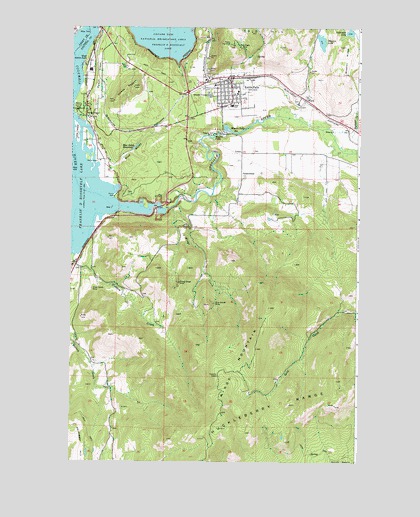
Kettle Falls, WA USGS Topographic Map
Click on map above to begin viewing in our Map Viewer.

This topographic map contains these locations and features:
Feature Name Type Latitude Longitude GNIS ID View Map
Ark MineMineN48.5510°W118.1117°1529554View Map
Avista Ash LandfillLocaleN48.6021°W118.0916°2605588View Map
Blue Grouse MineMineN48.5457°W118.0622°1516681View Map
Blue GulchValleyN48.5849°W118.1058°1516683View Map
Blue Gulch ReservoirReservoirN48.5904°W118.0978°1516684View Map
Blue Gulch Reservoir DamDamN48.5899°W118.0994°1532908View Map
Boise Cascade Mill Waste PondReservoirN48.6145°W118.1168°1532906View Map
Boise Cascade Mill Waste Pond DamDamN48.6149°W118.1178°1532905View Map
Broad Gauge MineMineN48.5516°W118.0778°1516965View Map
City of Kettle FallsCivilN48.6057°W118.0598°2411540View Map
Colville RiverStreamN48.5730°W118.1067°1517986View Map
Cousins CabinLocaleN48.5246°W118.0608°1518207View Map
Fuhrman LakeLakeN48.6236°W118.0048°1519848View Map
Goodwin StationLocaleN48.6038°W118.0242°1530778View Map
GreenwoodPopulated PlaceN48.5824°W118.0497°1520344View Map
Grey Eagle MineMineN48.6191°W118.0519°1520353View Map
Hallam CreekStreamN48.5591°W118.1236°1520471View Map
Hawks NestSummitN48.6074°W118.0980°1520615View Map
Highland CreekStreamN48.5935°W118.0039°1520796View Map
Kettle FallsPopulated PlaceN48.6107°W118.0558°1530955View Map
Kettle Falls Adventist ChurchChurchN48.6032°W118.0575°2609549View Map
Kettle Falls Assembly of God ChurchChurchN48.6091°W118.0577°2609550View Map
Kettle Falls CampgroundLocaleN48.6021°W118.1233°1529556View Map
Kettle Falls Community ChurchChurchN48.6087°W118.0549°2609551View Map
Kettle Falls Elementary SchoolSchoolN48.6061°W118.0536°1530748View Map
Kettle Falls High SchoolSchoolN48.6002°W118.0589°1530746View Map
Kettle Falls Middle SchoolSchoolN48.6025°W118.0557°1530747View Map
Kettle Falls Police DepartmentBuildingN48.6094°W118.0576°2721880View Map
Kettle Falls Post OfficePost OfficeN48.6087°W118.0567°2769185View Map
Kettle Falls Public LibraryBuildingN48.6051°W118.0563°2610162View Map
Kettle Falls Volunteer Fire DepartmentBuildingN48.6096°W118.0576°2619399View Map
Kettle Falls Wastewater Treatment PlantLocaleN48.6069°W118.0661°2610757View Map
Lindseys Mobile Home ParkPopulated PlaceN48.6042°W118.0634°2607308View Map
Lions IslandIslandN48.5943°W118.1228°1522145View Map
Meyers FallsFallsN48.5941°W118.0604°1523038View Map
Meyers Falls CemeteryCemeteryN48.6066°W118.0628°1523039View Map
Meyers Falls DamDamN48.5949°W118.0578°1531963View Map
Meyers Falls ReservoirReservoirN48.5947°W118.0546°1523040View Map
Mingo CreekStreamN48.5738°W118.0792°1523236View Map
Mingo MountainSummitN48.5324°W118.0442°1523237View Map
Mission LakeLakeN48.6210°W118.0170°1523275View Map
Mission RidgeRidgeN48.6157°W118.0061°1523279View Map
Mountain View Mobile Home ParkPopulated PlaceN48.5972°W118.0836°2607309View Map
New Life Apostolic ChurchChurchN48.6109°W118.0604°2609552View Map
Old Kettle Falls Recreation SiteParkN48.5863°W118.1133°1529555View Map
Peach CrestRidgeN48.6107°W118.1130°1524266View Map
Pentecostal ChurchChurchN48.6118°W118.0502°2609554View Map
Silver Queen MineMineN48.5493°W118.1155°1525791View Map
Stevens County Sanitary LandfillLocaleN48.5811°W118.0880°2605567View Map
WardPopulated PlaceN48.6043°W118.0233°1531531View Map
West Kettle FallsLocaleN48.6146°W118.1192°1527989View Map
Yellow Pine Mobile Home ParkPopulated PlaceN48.6095°W118.0722°2607310View Map

Note: Coordinates in the location and feature list above are referenced to NAD83 datum.


Copyright (C) 2008-2024 Ryan Niemi / Sunset Dynamics ... All Rights Reserved