TopoQuest Logo
Do you find TopoQuest useful?
Help keep TopoQuest running and adding new maps/features by donating!
Bitcoin:  19c7KJd3qBynnjoSw5npx9KScwjBe4ifkT
Litecoin:  LXs6TkuXGGXo1vDsWCkWVdjQX94eUKd6ui
Home View Maps Find Maps Find Places Resources & Links


Kinde East, Michigan Topographic Map

USGS Map Title: Kinde East, MI
USGS Map MRC: 43082H8
DRG (GeoTIFF) Download: o43082h8.tif


Neighboring USGS Topographic Map Quads:


  Port Austin West, MI  
44083A1
 

  Port Austin East, MI  
44082A8
 

  Huron City, MI  
44082A7
 

  Kinde West, MI  
43083H1
 

  Kinde East, MI  
43082H8
 

  Redman, MI  
43082H7
 

  Bad Axe West, MI  
43083G1
 

  Bad Axe East, MI  
43082G8
 

  Bad Axe SE, MI  
43082G7


Map MRC Location:

N44°
W83°
N44°
W82°
H8 H7 H6 H5 H4 H3 H2 H1
G8 G7 G6 G5 G4 G3 G2 G1
F8 F7 F6 F5 F4 F3 F2 F1
E8 E7 E6 E5 E4 E3 E2 E1
D8 D7 D6 D5 D4 D3 D2 D1
C8 C7 C6 C5 C4 C3 C2 C1
B8 B7 B6 B5 B4 B3 B2 B1
A8 A7 A6 A5 A4 A3 A2 A1
N43°
W83°
N43°
W82°

Kinde East, MI USGS 1:24K Topographic Map Preview:
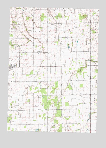
Kinde East, MI USGS Topographic Map
Click on map above to begin viewing in our Map Viewer.

This topographic map contains these locations and features:
Feature Name Type Latitude Longitude GNIS ID View Map
Carr DrainCanalN43.9042°W82.8930°622773View Map
Church SchoolSchoolN43.8814°W82.9833°623304View Map
Cramp DrainCanalN43.9870°W82.9336°623957View Map
Filion DrainCanalN43.8783°W82.9927°625948View Map
Filion StationLocaleN43.8958°W82.9950°2548446View Map
GlencoePopulated PlaceN43.9642°W82.8858°1617586View Map
Glencoe Post Office (historical)Post OfficeN43.9642°W82.8858°2548598View Map
KindePopulated PlaceN43.9395°W82.9969°629684View Map
Kinde Area Fire DepartmentBuildingN43.9395°W82.9971°2548423View Map
Kinde Police DepartmentBuildingN43.9395°W82.9935°2737576View Map
Kinde Presbyterian ChurchChurchN43.9386°W82.9975°2548422View Map
Kinde StationLocaleN43.9378°W82.9953°2548418View Map
Kinde Village HallBuildingN43.9392°W82.9972°2548421View Map
Lincoln DrainCanalN43.9097°W82.9277°630446View Map
Marsa DrainCanalN43.8836°W82.9166°631610View Map
Pitcher DrainCanalN43.9033°W82.9797°635049View Map
Rice DrainCanalN43.9400°W82.9499°635838View Map
Saint Edward's ChurchChurchN43.9417°W82.9936°2548420View Map
Saint Mary of Czestochowa Roman Catholic Church Historical MarkerParkN43.9550°W82.9569°2548592View Map
Saint Mary's Polish Catholic CemeteryCemeteryN43.9555°W82.9561°2548550View Map
Saint Marys ChurchChurchN43.9553°W82.9561°636905View Map
Saint Peters Lutheran ChurchChurchN43.9414°W82.9969°2548419View Map
Township of DwightCivilN43.9843°W82.9469°1626199View Map
Township of LincolnCivilN43.8974°W82.9437°1626621View Map
Varney Post Office (historical)Post OfficeN43.9972°W82.9972°2548500View Map
Varney Station (historical)LocaleN43.9975°W82.9972°2548452View Map
Village of KindeCivilN43.9404°W82.9963°2398348View Map
Weber DrainCanalN43.9261°W82.9636°1615941View Map
WFMM-FM (Harbor Beach)TowerN43.9850°W82.9736°1625406View Map
Zion CemeteryCemeteryN43.9464°W82.8827°1616945View Map

Note: Coordinates in the location and feature list above are referenced to NAD83 datum.


Copyright (C) 2008-2024 Ryan Niemi / Sunset Dynamics ... All Rights Reserved