TopoQuest Logo
Do you find TopoQuest useful?
Help keep TopoQuest running and adding new maps/features by donating!
Bitcoin:  19c7KJd3qBynnjoSw5npx9KScwjBe4ifkT
Litecoin:  LXs6TkuXGGXo1vDsWCkWVdjQX94eUKd6ui
Home View Maps Find Maps Find Places Resources & Links


Aetna Springs, California Topographic Map

USGS Map Title: Aetna Springs, CA
USGS Map MRC: 38122F4
DRG (GeoTIFF) Download: o38122f4.tif


Neighboring USGS Topographic Map Quads:


  Middletown, CA  
38122G5
 

  Jericho Valley, CA  
38122G4
 

  Knoxville, CA  
38122G3
 

  Detert Reservoir, CA  
38122F5
 

  Aetna Springs, CA  
38122F4
 

  Walter Springs, CA  
38122F3
 

  Calistoga, CA  
38122E5
 

  Saint Helena, CA  
38122E4
 

  Chiles Valley, CA  
38122E3


Map MRC Location:

N39°
W123°
N39°
W122°
H8 H7 H6 H5 H4 H3 H2 H1
G8 G7 G6 G5 G4 G3 G2 G1
F8 F7 F6 F5 F4 F3 F2 F1
E8 E7 E6 E5 E4 E3 E2 E1
D8 D7 D6 D5 D4 D3 D2 D1
C8 C7 C6 C5 C4 C3 C2 C1
B8 B7 B6 B5 B4 B3 B2 B1
A8 A7 A6 A5 A4 A3 A2 A1
N38°
W123°
N38°
W122°

Aetna Springs, CA USGS 1:24K Topographic Map Preview:
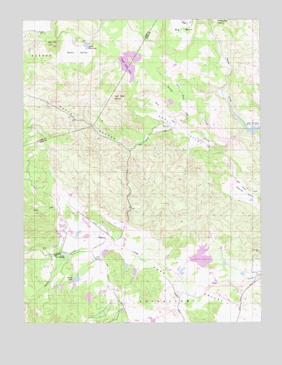
Aetna Springs, CA USGS Topographic Map
Click on map above to begin viewing in our Map Viewer.

This topographic map contains these locations and features:
Feature Name Type Latitude Longitude GNIS ID View Map
Aetna MineMineN38.6560°W122.4950°1657251View Map
Aetna SpringsPopulated PlaceN38.6535°W122.4828°1659686View Map
Aetna Springs Golf CourseLocaleN38.6585°W122.4811°1800192View Map
Aetna Springs Post Office (historical)Post OfficeN38.6535°W122.4828°2026835View Map
Big BasinBasinN38.7466°W122.4164°233496View Map
Black Oak VillaLocaleN38.7143°W122.4872°233511View Map
Blanchard-Offner 2416 DamDamN38.6366°W122.4678°1664362View Map
Bohn ValleyValleyN38.7403°W122.4664°233530View Map
Burns 1419 DamDamN38.6482°W122.4894°1664315View Map
Butts CanyonValleyN38.7054°W122.4259°233589View Map
Butts CreekStreamN38.7041°W122.3816°233590View Map
Davis 1416 DamDamN38.6482°W122.4461°1664313View Map
Deer Creek 3414 DamDamN38.6482°W122.4261°1664506View Map
Devils Head PeakSummitN38.7482°W122.3950°233781View Map
Dick Week 418 DamDamN38.6482°W122.4061°1663878View Map
Duvall 414 DamDamN38.6432°W122.4711°1663874View Map
Duvall LakeReservoirN38.6432°W122.4733°233812View Map
Goat HillSummitN38.7393°W122.4850°233935View Map
James CreekStreamN38.6724°W122.4778°234079View Map
Lower Bohn LakeReservoirN38.7392°W122.4674°234206View Map
Routan CreekStreamN38.6996°W122.3928°234593View Map
Snell CreekStreamN38.7035°W122.4114°234752View Map
Snell PeakSummitN38.7171°W122.4511°234753View Map
Snell ValleyValleyN38.6985°W122.4033°234755View Map
Swartz CreekStreamN38.6591°W122.4578°235879View Map
Upper Bohn 3410 DamDamN38.7332°W122.4378°1664379View Map
Upper Bohn LakeReservoirN38.7322°W122.4448°253239View Map
Weeks LakeReservoirN38.6517°W122.4072°1657248View Map
White Rock MineMineN38.6543°W122.3769°237673View Map

Note: Coordinates in the location and feature list above are referenced to NAD83 datum.


Copyright (C) 2008-2025 Ryan Niemi / Sunset Dynamics ... All Rights Reserved