TopoQuest Logo
Do you find TopoQuest useful?
Help keep TopoQuest running and adding new maps/features by donating!
Bitcoin:  19c7KJd3qBynnjoSw5npx9KScwjBe4ifkT
Litecoin:  LXs6TkuXGGXo1vDsWCkWVdjQX94eUKd6ui
Home View Maps Find Maps Find Places Resources & Links


Kiomatia, Texas Topographic Map

USGS Map Title: Kiomatia, TX
USGS Map MRC: 33095H2
DRG (GeoTIFF) Download: o33095h2.tif


Neighboring USGS Topographic Map Quads:


  Fort Towson, OK  
34095A3
 

  Swink, OK  
34095A2
 

  Wright City, OK  
34095A1
 

  Frogville, OK  
33095H3
 

  Kiomatia, TX  
33095H2
 

  Millerton, OK  
33095H1
 

  Woodland, TX  
33095G3
 

  Manchester, TX  
33095G2
 

  Negley, TX  
33095G1


Map MRC Location:

N34°
W96°
N34°
W95°
H8 H7 H6 H5 H4 H3 H2 H1
G8 G7 G6 G5 G4 G3 G2 G1
F8 F7 F6 F5 F4 F3 F2 F1
E8 E7 E6 E5 E4 E3 E2 E1
D8 D7 D6 D5 D4 D3 D2 D1
C8 C7 C6 C5 C4 C3 C2 C1
B8 B7 B6 B5 B4 B3 B2 B1
A8 A7 A6 A5 A4 A3 A2 A1
N33°
W96°
N33°
W95°

Kiomatia, TX USGS 1:24K Topographic Map Preview:
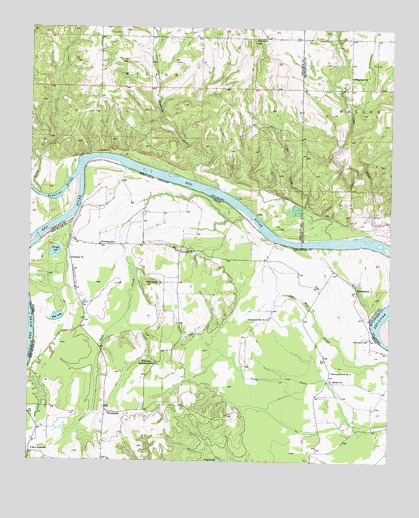
Kiomatia, TX USGS Topographic Map
Click on map above to begin viewing in our Map Viewer.

This topographic map contains these locations and features:
Feature Name Type Latitude Longitude GNIS ID View Map
Bartonville ChurchChurchN33.9268°W95.2094°1351565View Map
Cedar CreekStreamN33.9393°W95.1455°1091067View Map
DavenportPopulated PlaceN33.9251°W95.1366°1355666View Map
Davenport SchoolSchoolN33.9107°W95.1325°1355668View Map
Davenport School Number 1SchoolN33.9012°W95.1452°1355669View Map
Davenport School Number 2SchoolN33.9162°W95.1669°1355670View Map
Doaksville CreekStreamN33.9554°W95.1919°1092108View Map
Ford CreekStreamN33.9451°W95.1727°1357544View Map
Gates CreekStreamN33.9518°W95.2463°1093149View Map
Kiamichi RiverStreamN33.9611°W95.2294°77399View Map
KiomatiaPopulated PlaceN33.8893°W95.2230°1360685View Map
Kiomatia Agricultural SchoolSchoolN33.9037°W95.2058°1360686View Map
Kiomatia ChurchChurchN33.9332°W95.2363°1360687View Map
Kiomatia SchoolSchoolN33.9376°W95.2252°1360688View Map
Mud LakeLakeN33.9163°W95.2398°1363411View Map
New Hope SchoolSchoolN33.8782°W95.2486°1363746View Map
Pilot KnobSummitN33.9959°W95.1719°1096642View Map
Riverside ChurchChurchN33.9357°W95.1977°1366535View Map
Siloam ChurchChurchN33.8987°W95.1447°1368270View Map
Watermill ChurchChurchN33.9859°W95.1388°1099423View Map
Wright LakeLakeN33.9354°W95.2414°1371977View Map

Note: Coordinates in the location and feature list above are referenced to NAD83 datum.


Copyright (C) 2008-2025 Ryan Niemi / Sunset Dynamics ... All Rights Reserved