TopoQuest Logo
Do you find TopoQuest useful?
Help keep TopoQuest running and adding new maps/features by donating!
Bitcoin:  19c7KJd3qBynnjoSw5npx9KScwjBe4ifkT
Litecoin:  LXs6TkuXGGXo1vDsWCkWVdjQX94eUKd6ui
Home View Maps Find Maps Find Places Resources & Links


Frogville, Oklahoma Topographic Map

USGS Map Title: Frogville, OK
USGS Map MRC: 33095H3
DRG (GeoTIFF) Download: o33095h3.tif


Neighboring USGS Topographic Map Quads:


  Hugo Dam, OK  
34095A4
 

  Fort Towson, OK  
34095A3
 

  Swink, OK  
34095A2
 

  Shoals, OK  
33095H4
 

  Frogville, OK  
33095H3
 

  Kiomatia, TX  
33095H2
 

  Slate Shoals, TX  
33095G4
 

  Woodland, TX  
33095G3
 

  Manchester, TX  
33095G2


Map MRC Location:

N34°
W96°
N34°
W95°
H8 H7 H6 H5 H4 H3 H2 H1
G8 G7 G6 G5 G4 G3 G2 G1
F8 F7 F6 F5 F4 F3 F2 F1
E8 E7 E6 E5 E4 E3 E2 E1
D8 D7 D6 D5 D4 D3 D2 D1
C8 C7 C6 C5 C4 C3 C2 C1
B8 B7 B6 B5 B4 B3 B2 B1
A8 A7 A6 A5 A4 A3 A2 A1
N33°
W96°
N33°
W95°

Frogville, OK USGS 1:24K Topographic Map Preview:
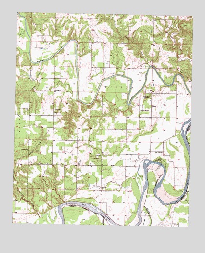
Frogville, OK USGS Topographic Map
Click on map above to begin viewing in our Map Viewer.

This topographic map contains these locations and features:
Feature Name Type Latitude Longitude GNIS ID View Map
Bird CreekStreamN33.9698°W95.2794°1090153View Map
Bowman IslandIslandN33.8798°W95.2813°1090429View Map
Cedar CreekStreamN33.9932°W95.2602°1091084View Map
Eastern Star SchoolSchoolN33.9434°W95.2858°1092459View Map
Everidge CemeteryCemeteryN33.9433°W95.3663°1092673View Map
Everidge Lake Cut-offBendN33.9082°W95.2722°1357133View Map
FrogvillePopulated PlaceN33.8976°W95.3127°1100435View Map
Frogville CemeteryCemeteryN33.9141°W95.3142°1093072View Map
Frogville Creek Site 1 DamDamN33.9068°W95.3236°1751896View Map
Frogville Creek Site 1 ReservoirReservoirN33.9068°W95.3236°1751897View Map
Frogville Creek Site 2 DamDamN33.9201°W95.3152°1751898View Map
Frogville Creek Site 2 ReservoirReservoirN33.9201°W95.3165°1751899View Map
Garvin SchoolSchoolN33.9826°W95.3561°1093143View Map
Goodwater CreekStreamN33.8826°W95.3430°1093258View Map
HuskeyPopulated PlaceN33.9459°W95.2783°1100517View Map
Lake Raymond GaryReservoirN33.9932°W95.2632°1757536View Map
Lake Raymond Gary DamDamN33.9818°W95.2636°1757535View Map
Lake View SchoolSchoolN33.9193°W95.2700°1094480View Map
Missionary CemeteryCemeteryN33.9191°W95.3652°1095453View Map
North Sandy BranchStreamN33.9529°W95.3727°1096001View Map
Oakes CemeteryCemeteryN33.9184°W95.3591°1096161View Map
Oma SchoolSchoolN33.9165°W95.3130°1096268View Map
Plainview SchoolSchoolN33.9409°W95.3469°1096706View Map
Raymond Gary State ParkParkN33.9940°W95.2661°1763574View Map
Rock CreekStreamN33.9895°W95.3686°1097296View Map
Rock CreekStreamN33.9979°W95.3713°1097330View Map
Rosemound SchoolLocaleN33.9518°W95.2788°1097457View Map
Saint Johns ChurchChurchN33.9543°W95.3472°1097601View Map
Sandy BranchStreamN33.9707°W95.3569°1097795View Map
South Sandy BranchStreamN33.9529°W95.3727°1098276View Map
Spring Hill CemeteryCemeteryN33.9430°W95.3468°1098437View Map

Note: Coordinates in the location and feature list above are referenced to NAD83 datum.


Copyright (C) 2008-2024 Ryan Niemi / Sunset Dynamics ... All Rights Reserved