TopoQuest Logo
Do you find TopoQuest useful?
Help keep TopoQuest running and adding new maps/features by donating!
Bitcoin:  19c7KJd3qBynnjoSw5npx9KScwjBe4ifkT
Litecoin:  LXs6TkuXGGXo1vDsWCkWVdjQX94eUKd6ui
Home View Maps Find Maps Find Places Resources & Links


Woodland, Texas Topographic Map

USGS Map Title: Woodland, TX
USGS Map MRC: 33095G3
DRG (GeoTIFF) Download: o33095g3.tif


Neighboring USGS Topographic Map Quads:


  Shoals, OK  
33095H4
 

  Frogville, OK  
33095H3
 

  Kiomatia, TX  
33095H2
 

  Slate Shoals, TX  
33095G4
 

  Woodland, TX  
33095G3
 

  Manchester, TX  
33095G2
 

  Blossom, TX  
33095F4
 

  Detroit, TX  
33095F3
 

  Bagwell, TX  
33095F2


Map MRC Location:

N34°
W96°
N34°
W95°
H8 H7 H6 H5 H4 H3 H2 H1
G8 G7 G6 G5 G4 G3 G2 G1
F8 F7 F6 F5 F4 F3 F2 F1
E8 E7 E6 E5 E4 E3 E2 E1
D8 D7 D6 D5 D4 D3 D2 D1
C8 C7 C6 C5 C4 C3 C2 C1
B8 B7 B6 B5 B4 B3 B2 B1
A8 A7 A6 A5 A4 A3 A2 A1
N33°
W96°
N33°
W95°

Woodland, TX USGS 1:24K Topographic Map Preview:
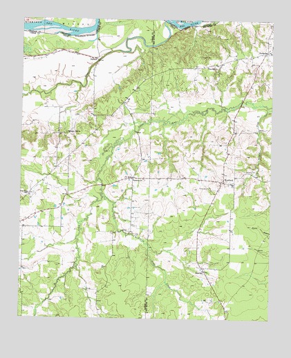
Woodland, TX USGS Topographic Map
Click on map above to begin viewing in our Map Viewer.

This topographic map contains these locations and features:
Feature Name Type Latitude Longitude GNIS ID View Map
FaulknerPopulated PlaceN33.8590°W95.3402°1379758View Map
Faulkner ChurchChurchN33.8090°W95.3191°1357266View Map
Fought CreekStreamN33.7740°W95.3741°1967716View Map
Hall LakeReservoirN33.8701°W95.2702°1860384View Map
Hall Lake DamDamN33.8701°W95.2702°1860383View Map
Hickory Hill ChurchChurchN33.8279°W95.3516°1359128View Map
KanawhaPopulated PlaceN33.8615°W95.2530°1360492View Map
Lone Star SchoolSchoolN33.8023°W95.3713°1361673View Map
Nolan CreekStreamN33.8015°W95.3350°1363956View Map
Pin HookPopulated PlaceN33.8096°W95.3194°1380356View Map
Pine CreekStreamN33.8732°W95.2997°1365274View Map
Pine Hill CemeteryCemeteryN33.8601°W95.2858°1365285View Map
Pine Hill ChurchChurchN33.8554°W95.2827°1365290View Map
Rogers LakeReservoirN33.8285°W95.2804°1860382View Map
Rogers Lake DamDamN33.8284°W95.2819°1860381View Map
S David Ramsey LakeReservoirN33.8168°W95.3269°1857891View Map
S David Ramsey Lake DamDamN33.8168°W95.3269°1857890View Map
Tinsley CemeteryCemeteryN33.8051°W95.2822°1369967View Map
Ward SchoolSchoolN33.7696°W95.2827°1370854View Map
WoodlandPopulated PlaceN33.8071°W95.2738°1371913View Map
Woodland CemeteryCemeteryN33.8121°W95.2630°1371915View Map

Note: Coordinates in the location and feature list above are referenced to NAD83 datum.


Copyright (C) 2008-2025 Ryan Niemi / Sunset Dynamics ... All Rights Reserved