TopoQuest Logo
Do you find TopoQuest useful?
Help keep TopoQuest running and adding new maps/features by donating!
Bitcoin:  19c7KJd3qBynnjoSw5npx9KScwjBe4ifkT
Litecoin:  LXs6TkuXGGXo1vDsWCkWVdjQX94eUKd6ui
Home View Maps Find Maps Find Places Resources & Links


Kipton, Ohio Topographic Map

USGS Map Title: Kipton, OH
USGS Map MRC: 41082C3
DRG (GeoTIFF) Download: o41082c3.tif


Neighboring USGS Topographic Map Quads:


  Vermilion West, OH  
41082D4
 

  Vermilion East, OH  
41082D3
 

  Lorain, OH  
41082D2
 

  Berlin Heights, OH  
41082C4
 

  Kipton, OH  
41082C3
 

  Oberlin, OH  
41082C2
 

  Clarksfield, OH  
41082B4
 

  Brighton, OH  
41082B3
 

  Wellington, OH  
41082B2


Map MRC Location:

N42°
W83°
N42°
W82°
H8 H7 H6 H5 H4 H3 H2 H1
G8 G7 G6 G5 G4 G3 G2 G1
F8 F7 F6 F5 F4 F3 F2 F1
E8 E7 E6 E5 E4 E3 E2 E1
D8 D7 D6 D5 D4 D3 D2 D1
C8 C7 C6 C5 C4 C3 C2 C1
B8 B7 B6 B5 B4 B3 B2 B1
A8 A7 A6 A5 A4 A3 A2 A1
N41°
W83°
N41°
W82°

Kipton, OH USGS 1:24K Topographic Map Preview:
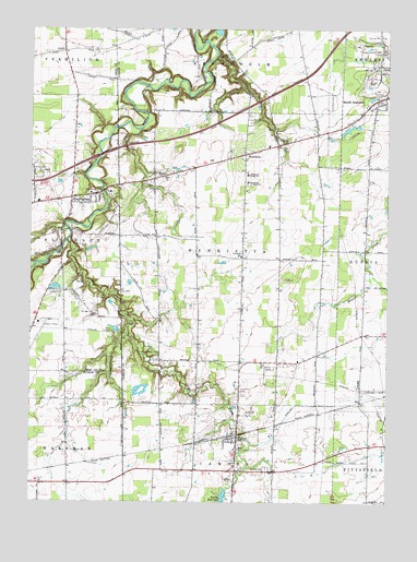
Kipton, OH USGS Topographic Map
Click on map above to begin viewing in our Map Viewer.

This topographic map contains these locations and features:
Feature Name Type Latitude Longitude GNIS ID View Map
Andress CemeteryCemeteryN41.3367°W82.3315°1963552View Map
AxtelPopulated PlaceN41.3687°W82.3638°1064367View Map
Axtel Post Office (historical)Post OfficeN41.3681°W82.3638°1984058View Map
BirminghamPopulated PlaceN41.3300°W82.3607°1038057View Map
Birmingham CemeteryCemeteryN41.3275°W82.3568°1049991View Map
Birmingham Methodist ChurchChurchN41.3287°W82.3574°1062062View Map
Birmingham Post OfficePost OfficeN41.3306°W82.3610°1984068View Map
Camden CemeteryCemeteryN41.2589°W82.2921°1038652View Map
Camden Township Fire DepartmentBuildingN41.2668°W82.3032°2549783View Map
Camp TimberlineLocaleN41.2953°W82.3454°1038757View Map
Dean Road BridgeBridgeN41.3489°W82.3449°1069176View Map
East Fork Vermilion RiverStreamN41.3195°W82.3616°1039956View Map
Firelands Boy Scout LakeReservoirN41.2787°W82.3358°1077792View Map
Firelands Boy Scout Lake DamDamN41.2784°W82.3382°1077791View Map
Firelands Community ParkParkN41.3312°W82.3504°1040450View Map
Firelands Elementary SchoolSchoolN41.3148°W82.3013°1081310View Map
Firelands High SchoolSchoolN41.3364°W82.2990°1040451View Map
Firelands Junior High SchoolSchoolN41.3342°W82.2996°1040452View Map
Firelands ReservationParkN41.2889°W82.3338°1040453View Map
Florence Township Fire DepartmentBuildingN41.3299°W82.3546°2549704View Map
Florence Township SchoolSchoolN41.3314°W82.3541°1049992View Map
Frankenburg CreekStreamN41.2937°W82.3404°1040645View Map
Harrison CemeteryCemeteryN41.3378°W82.3743°1041363View Map
HenriettaPopulated PlaceN41.3417°W82.3007°1064825View Map
Henrietta CemeteryCemeteryN41.2795°W82.3013°1041491View Map
Henrietta ChurchChurchN41.3362°W82.3299°1061422View Map
Henrietta Methodist CemeteryCemeteryN41.3363°W82.3288°1963553View Map
Henrietta Post Office (historical)Post OfficeN41.3417°W82.3013°2026357View Map
Henrietta United Church of ChristChurchN41.3200°W82.3418°1062141View Map
Hillcrest OrchardsLocaleN41.3392°W82.3022°2515673View Map
KiptonPopulated PlaceN41.2681°W82.3021°1064946View Map
Kipton Post OfficePost OfficeN41.2681°W82.3027°2026551View Map
Kipton QuarryMineN41.2739°W82.2967°2514403View Map
McDowell OrchardsLocaleN41.3425°W82.3136°2515680View Map
Miller OrchardsLocaleN41.3633°W82.2978°2515681View Map
Oberlin Airport (historical)AirportN41.2848°W82.2929°1082246View Map
Ortner AirportAirportN41.2974°W82.3720°1083087View Map
Sanders Hill CemeteryCemeteryN41.3456°W82.2852°1047117View Map
Schoepfle ArboretumLocaleN41.3287°W82.3466°1806272View Map
South AmherstPopulated PlaceN41.3559°W82.2538°1065346View Map
Township of HenriettaCivilN41.3149°W82.3054°1086511View Map
Union ChurchChurchN41.2631°W82.3041°1071636View Map
Village of KiptonCivilN41.2665°W82.3039°2398357View Map
Wolf RunStreamN41.3476°W82.3468°2680825View Map

Note: Coordinates in the location and feature list above are referenced to NAD83 datum.


Copyright (C) 2008-2024 Ryan Niemi / Sunset Dynamics ... All Rights Reserved