TopoQuest Logo
Do you find TopoQuest useful?
Help keep TopoQuest running and adding new maps/features by donating!
Bitcoin:  19c7KJd3qBynnjoSw5npx9KScwjBe4ifkT
Litecoin:  LXs6TkuXGGXo1vDsWCkWVdjQX94eUKd6ui
Home View Maps Find Maps Find Places Resources & Links


Knoxville, Arkansas Topographic Map

USGS Map Title: Knoxville, AR
USGS Map MRC: 35093D3
DRG (GeoTIFF) Download: o35093d3.tif


Neighboring USGS Topographic Map Quads:


  Ludwig, AR  
35093E4
 

  Hagarville, AR  
35093E3
 

  Treat, AR  
35093E2
 

  Clarksville, AR  
35093D4
 

  Knoxville, AR  
35093D3
 

  Lee Mountain, AR  
35093D2
 

  New Blaine, AR  
35093C4
 

  Delaware, AR  
35093C3
 

  Russellville West, AR  
35093C2


Map MRC Location:

N36°
W94°
N36°
W93°
H8 H7 H6 H5 H4 H3 H2 H1
G8 G7 G6 G5 G4 G3 G2 G1
F8 F7 F6 F5 F4 F3 F2 F1
E8 E7 E6 E5 E4 E3 E2 E1
D8 D7 D6 D5 D4 D3 D2 D1
C8 C7 C6 C5 C4 C3 C2 C1
B8 B7 B6 B5 B4 B3 B2 B1
A8 A7 A6 A5 A4 A3 A2 A1
N35°
W94°
N35°
W93°

Knoxville, AR USGS 1:24K Topographic Map Preview:
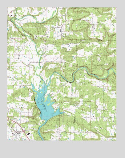
Knoxville, AR USGS Topographic Map
Click on map above to begin viewing in our Map Viewer.

This topographic map contains these locations and features:
Feature Name Type Latitude Longitude GNIS ID View Map
Bee BluffCliffN35.4037°W93.3382°46291View Map
Brown CemeteryCemeteryN35.4490°W93.3474°46997View Map
Burgess CemeteryCemeteryN35.4012°W93.2518°47191View Map
Cazort CemeteryCemeteryN35.4317°W93.3677°47556View Map
Cedar CreekStreamN35.3940°W93.3293°47593View Map
Colony MountainSummitN35.4967°W93.2941°71204View Map
Denny Church (historical)ChurchN35.4840°W93.2541°79132View Map
Faith Full Gospel ChurchChurchN35.4054°W93.3688°79220View Map
First Baptist Church of KnoxvilleChurchN35.3793°W93.3641°65143View Map
GarrettPopulated PlaceN35.4056°W93.3596°57797View Map
Hickey CemeteryCemeteryN35.4104°W93.3118°50041View Map
Hickey CemeteryCemeteryN35.4859°W93.3627°50042View Map
HickeytownPopulated PlaceN35.4048°W93.3107°57910View Map
HolmanPopulated PlaceN35.4845°W93.3110°57935View Map
Holman CemeteryCemeteryN35.4784°W93.3249°50256View Map
Holman-Lutherville Community CenterBuildingN35.4837°W93.2796°79218View Map
Horton MountainSummitN35.3781°W93.2802°62015View Map
Interchange 67CrossingN35.3840°W93.3574°58989View Map
Jackson BluffCliffN35.4759°W93.3513°50553View Map
Johnson County Rural Fire Department Station 7 LuthervilleBuildingN35.4845°W93.2773°2116647View Map
KnoxvillePopulated PlaceN35.3820°W93.3643°58027View Map
Knoxville CemeteryCemeteryN35.3756°W93.3682°50909View Map
Knoxville Fire SubstationBuildingN35.3873°W93.3505°2116669View Map
Knoxville Gas FieldOilfieldN35.3834°W93.3099°65154View Map
Knoxville Post OfficePost OfficeN35.3827°W93.3633°2781875View Map
Knoxville Volunteer Fire DepartmentBuildingN35.3795°W93.3661°2116670View Map
Lewis Johnson Family CemeteryCemeteryN35.4123°W93.3588°49350View Map
Little Piney CreekStreamN35.4256°W93.3302°72415View Map
Love CemeteryCemeteryN35.4148°W93.3691°51481View Map
LuthervillePopulated PlaceN35.4840°W93.2780°57100View Map
Lutherville MountainSummitN35.4790°W93.2991°58106View Map
Maddin CemeteryCemeteryN35.4212°W93.3171°77576View Map
Maddin ChapelChurchN35.4123°W93.3205°51597View Map
Minnow CreekStreamN35.4901°W93.3680°72694View Map
Mount Carmel CemeteryCemeteryN35.3979°W93.2652°64926View Map
Mount Carmel Cumberland Presbyterian ChurchChurchN35.3973°W93.2652°77706View Map
Nordin CemeteryCemeteryN35.4012°W93.2916°52793View Map
Opossum BranchStreamN35.4401°W93.3427°53059View Map
Perry BluffCliffN35.4109°W93.3432°53288View Map
Piney Bay Recreation AreaParkN35.3995°W93.3146°79177View Map
Pless (historical)Populated PlaceN35.4042°W93.2652°79153View Map
Pless Community CenterBuildingN35.4040°W93.2660°79219View Map
Pless School (historical)SchoolN35.4040°W93.2655°62016View Map
Price CemeteryCemeteryN35.4929°W93.3332°53791View Map
Reynolds CemeteryCemeteryN35.4420°W93.3085°53996View Map
RossPopulated PlaceN35.4551°W93.2532°78218View Map
Ross Gas FieldOilfieldN35.4287°W93.2693°62017View Map
Ross MountainSummitN35.4467°W93.2693°58525View Map
Round MountainSummitN35.4590°W93.3110°58535View Map
Saint Pauls CemeteryCemeteryN35.4773°W93.2774°79155View Map
Saint Pauls Lutheran School (historical)SchoolN35.4787°W93.2766°79217View Map
Sand Spring School (historical)SchoolN35.4462°W93.2602°62018View Map
Slover CreekStreamN35.4545°W93.3366°54916View Map
Spring SloughStreamN35.4331°W93.3371°55126View Map
Thompson MountainSummitN35.4745°W93.3355°58741View Map
Town of KnoxvilleCivilN35.3777°W93.3631°2405959View Map
Township of McKennonCivilN35.4035°W93.3147°66761View Map
Township of Sand Spring (historical)CivilN35.4515°W93.2571°70147View Map

Note: Coordinates in the location and feature list above are referenced to NAD83 datum.


Copyright (C) 2008-2024 Ryan Niemi / Sunset Dynamics ... All Rights Reserved