TopoQuest Logo
Do you find TopoQuest useful?
Help keep TopoQuest running and adding new maps/features by donating!
Bitcoin:  19c7KJd3qBynnjoSw5npx9KScwjBe4ifkT
Litecoin:  LXs6TkuXGGXo1vDsWCkWVdjQX94eUKd6ui
Home View Maps Find Maps Find Places Resources & Links


Clarksville, Arkansas Topographic Map

USGS Map Title: Clarksville, AR
USGS Map MRC: 35093D4
DRG (GeoTIFF) Download: o35093d4.tif


Neighboring USGS Topographic Map Quads:


  Harmony, AR  
35093E5
 

  Ludwig, AR  
35093E4
 

  Hagarville, AR  
35093E3
 

  Hartman, AR  
35093D5
 

  Clarksville, AR  
35093D4
 

  Knoxville, AR  
35093D3
 

  Scranton, AR  
35093C5
 

  New Blaine, AR  
35093C4
 

  Delaware, AR  
35093C3


Map MRC Location:

N36°
W94°
N36°
W93°
H8 H7 H6 H5 H4 H3 H2 H1
G8 G7 G6 G5 G4 G3 G2 G1
F8 F7 F6 F5 F4 F3 F2 F1
E8 E7 E6 E5 E4 E3 E2 E1
D8 D7 D6 D5 D4 D3 D2 D1
C8 C7 C6 C5 C4 C3 C2 C1
B8 B7 B6 B5 B4 B3 B2 B1
A8 A7 A6 A5 A4 A3 A2 A1
N35°
W94°
N35°
W93°

Clarksville, AR USGS 1:24K Topographic Map Preview:
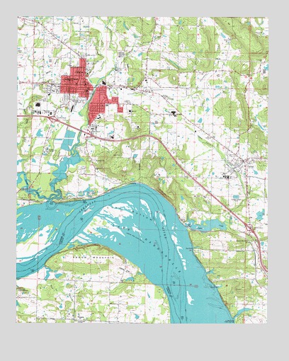
Clarksville, AR USGS Topographic Map
Click on map above to begin viewing in our Map Viewer.

This topographic map contains these locations and features:
Feature Name Type Latitude Longitude GNIS ID View Map
Blakeley CemeteryCemeteryN35.4440°W93.3949°46704View Map
Cabin Creek Baptist ChurchChurchN35.4343°W93.4052°79249View Map
Cabin Creek Public Use AreaParkN35.3770°W93.3896°79251View Map
Canter CemeteryCemeteryN35.4412°W93.4399°47452View Map
City of ClarksvilleCivilN35.4567°W93.4808°2404060View Map
City of LamarCivilN35.4439°W93.3950°2404879View Map
ClarksvillePopulated PlaceN35.4715°W93.4666°76626View Map
Clarksville Adult Education CenterSchoolN35.4801°W93.4735°79244View Map
Clarksville City ParkParkN35.4709°W93.4824°79245View Map
Clarksville Elementary SchoolSchoolN35.4612°W93.4830°65134View Map
Clarksville Fire Department Central StationBuildingN35.4705°W93.4683°2116279View Map
Clarksville High SchoolSchoolN35.4606°W93.4835°65136View Map
Clarksville Junior High SchoolSchoolN35.4612°W93.4888°65137View Map
Clarksville Municipal AirportAirportN35.4703°W93.4331°83658View Map
Clarksville Police DepartmentBuildingN35.4718°W93.4729°2118866View Map
Clarksville Post OfficePost OfficeN35.4704°W93.4652°84293View Map
Craven BranchStreamN35.4712°W93.4621°76702View Map
Cuba BottomBendN35.4215°W93.4410°48248View Map
First Baptist ChurchChurchN35.4726°W93.4707°65141View Map
First Freewill Baptist ChurchChurchN35.4662°W93.4255°79248View Map
First Presbyterian ChurchChurchN35.4726°W93.4660°65144View Map
Grace James School (historical)SchoolN35.4784°W93.4641°79135View Map
Greenbrier CreekStreamN35.4756°W93.4569°71836View Map
Harris PondReservoirN35.4195°W93.3789°80014View Map
Harris Pond DamDamN35.4184°W93.3785°80013View Map
Holly Redeemer CemeteryCemeteryN35.4729°W93.4457°50234View Map
Hospital HeliportAirportN35.4676°W93.4191°83661View Map
Hurie School (historical)SchoolN35.4720°W93.4738°79138View Map
Interchange 57CrossingN35.4584°W93.4819°58986View Map
Interchange 58CrossingN35.4531°W93.4655°58987View Map
Interchange 64CrossingN35.4148°W93.3841°58988View Map
JamestownPopulated PlaceN35.4420°W93.4627°50585View Map
Jamestown Assembly of God ChurchChurchN35.4379°W93.4607°65151View Map
Johnson County CourthouseBuildingN35.4706°W93.4652°65152View Map
Johnson County Regional Hospital HeliportAirportN35.4448°W93.4449°83659View Map
Johnson County Sheriff's OfficeBuildingN35.4559°W93.4586°2118867View Map
Johnson Regional Medical CenterHospitalN35.4619°W93.4450°65153View Map
KLYR-AM (Clarksville)TowerN35.4726°W93.4913°85291View Map
Knoxville JunctionPopulated PlaceN35.4090°W93.3846°57081View Map
Kraus Middle SchoolSchoolN35.4610°W93.4898°2039094View Map
Kraus SchoolSchoolN35.4609°W93.4896°79246View Map
LamarPopulated PlaceN35.4406°W93.3880°77440View Map
Lamar Baptist ChurchChurchN35.4376°W93.3857°65155View Map
Lamar Elementary SchoolSchoolN35.4352°W93.3972°65156View Map
Lamar High SchoolSchoolN35.4346°W93.3950°65157View Map
Lamar Middle SchoolSchoolN35.4364°W93.3974°79250View Map
Lamar Police DepartmentBuildingN35.4451°W93.3937°2118870View Map
Lamar Volunteer Fire StationBuildingN35.4451°W93.3937°2116697View Map
Lee CemeteryCemeteryN35.4845°W93.4605°79243View Map
Little Spadra CreekStreamN35.4287°W93.4799°72423View Map
Little Willett BranchStreamN35.4634°W93.4971°72428View Map
Macedonia CemeteryCemeteryN35.4931°W93.3802°51550View Map
Michie SchoolSchoolN35.4801°W93.4738°79141View Map
Mount Olive United Methodist ChurchChurchN35.4720°W93.4199°77728View Map
Mud BranchStreamN35.3993°W93.4863°72799View Map
Oakland ChurchChurchN35.4548°W93.4249°52960View Map
Oakland Memorial CemeteryCemeteryN35.4670°W93.4757°77891View Map
Pittsburgh Baptist ChurchChurchN35.4048°W93.3868°78025View Map
Pryor CemeteryCemeteryN35.4881°W93.4805°53835View Map
Pyron Elementary SchoolSchoolN35.4614°W93.4910°79247View Map
Ragon MountainSummitN35.3998°W93.4596°53875View Map
Second Baptist ChurchChurchN35.4637°W93.4577°65172View Map
Sherwood Shopping CenterLocaleN35.4556°W93.4632°65173View Map
SpadraPopulated PlaceN35.4251°W93.4938°58665View Map
Spadra BranchStreamN35.4804°W93.4519°78422View Map
Spadra CreekStreamN35.4248°W93.4649°73658View Map
Spadra Gas FieldOilfieldN35.4043°W93.4607°64172View Map
TokalonPopulated PlaceN35.3765°W93.4713°55588View Map
Township of PittsburgCivilN35.4339°W93.3761°66766View Map
Township of SpadraCivilN35.4734°W93.4760°66770View Map
Tritt LakeReservoirN35.3953°W93.4845°81102View Map
Tritt Lake DamDamN35.3968°W93.4852°81101View Map
University of the OzarksSchoolN35.4776°W93.4680°76651View Map
Walton CemeteryCemeteryN35.4854°W93.4985°56028View Map
Ware Chapel CemeteryCemeteryN35.3753°W93.4704°79162View Map

Note: Coordinates in the location and feature list above are referenced to NAD83 datum.


Copyright (C) 2008-2024 Ryan Niemi / Sunset Dynamics ... All Rights Reserved