TopoQuest Logo
Do you find TopoQuest useful?
Help keep TopoQuest running and adding new maps/features by donating!
Bitcoin:  19c7KJd3qBynnjoSw5npx9KScwjBe4ifkT
Litecoin:  LXs6TkuXGGXo1vDsWCkWVdjQX94eUKd6ui
Home View Maps Find Maps Find Places Resources & Links


Clifton House, New Mexico Topographic Map

USGS Map Title: Clifton House, NM
USGS Map MRC: 36104G4
DRG (GeoTIFF) Download: o36104g4.tif


Neighboring USGS Topographic Map Quads:


  Tin Pan Canyon, NM  
36104H5
 

  Raton, NM  
36104H4
 

  Yankee, NM  
36104H3
 

  Red River Peak, NM  
36104G5
 

  Clifton House, NM  
36104G4
 

  Hunter Mesa, NM  
36104G3
 

  Koehler, NM  
36104F5
 

  Eagle Tail Mountain, NM  
36104F4
 

  Tinaja Mountain, NM  
36104F3


Map MRC Location:

N37°
W105°
N37°
W104°
H8 H7 H6 H5 H4 H3 H2 H1
G8 G7 G6 G5 G4 G3 G2 G1
F8 F7 F6 F5 F4 F3 F2 F1
E8 E7 E6 E5 E4 E3 E2 E1
D8 D7 D6 D5 D4 D3 D2 D1
C8 C7 C6 C5 C4 C3 C2 C1
B8 B7 B6 B5 B4 B3 B2 B1
A8 A7 A6 A5 A4 A3 A2 A1
N36°
W105°
N36°
W104°

Clifton House, NM USGS 1:24K Topographic Map Preview:
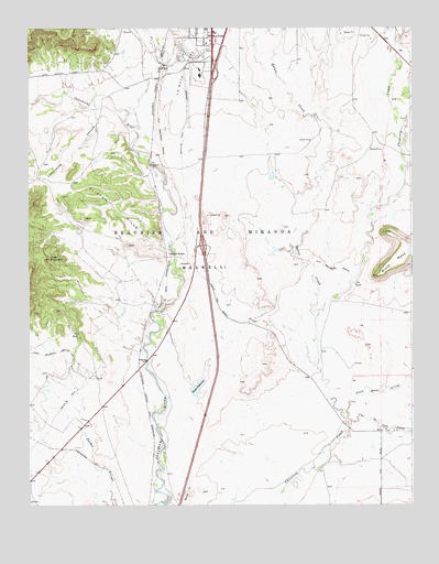
Clifton House, NM USGS Topographic Map
Click on map above to begin viewing in our Map Viewer.

This topographic map contains these locations and features:
Feature Name Type Latitude Longitude GNIS ID View Map
Black Mesa ArroyoStreamN36.7725°W104.3964°886425View Map
Clifton HillsSummitN36.8309°W104.4886°887689View Map
Clifton HouseLocaleN36.8159°W104.4544°902217View Map
Clifton House Site Historical MarkerParkN36.8159°W104.4544°932236View Map
Cottonwood CanyonValleyN36.8534°W104.4780°887903View Map
Davis ReservoirReservoirN36.7808°W104.4455°923966View Map
Davis Reservoir DamDamN36.7800°W104.4472°923965View Map
DillonPopulated PlaceN36.8656°W104.4564°898541View Map
Green MountainSummitN36.8145°W104.4933°889586View Map
La Mesa ParkParkN36.8639°W104.4497°890824View Map
La Mesa Park Airport (historical)AirportN36.8642°W104.4491°937006View Map
Miners' Colfax Medical CenterHospitalN36.8627°W104.4421°901286View Map
MooreLocaleN36.7609°W104.4055°924778View Map
Moore PitMineN36.7922°W104.4194°917894View Map
New Mexico State Police District 2 RatonBuildingN36.8705°W104.4328°2722625View Map
Raton CreekStreamN36.8003°W104.4080°893672View Map
Raton DivisionCivilN36.7962°W104.4459°1937573View Map
StocktonLocaleN36.7922°W104.4483°902748View Map
Una de Gato CreekStreamN36.7720°W104.3961°897503View Map

Note: Coordinates in the location and feature list above are referenced to NAD83 datum.


Copyright (C) 2008-2025 Ryan Niemi / Sunset Dynamics ... All Rights Reserved