TopoQuest Logo
Do you find TopoQuest useful?
Help keep TopoQuest running and adding new maps/features by donating!
Bitcoin:  19c7KJd3qBynnjoSw5npx9KScwjBe4ifkT
Litecoin:  LXs6TkuXGGXo1vDsWCkWVdjQX94eUKd6ui
Home View Maps Find Maps Find Places Resources & Links


Koleen, Indiana Topographic Map

USGS Map Title: Koleen, IN
USGS Map MRC: 38086H7
DRG (GeoTIFF) Download: o38086h7.tif


Neighboring USGS Topographic Map Quads:


  Bloomfield, IN  
39086A8
 

  Solsberry, IN  
39086A7
 

  Stanford, IN  
39086A6
 

  Scotland, IN  
38086H8
 

  Koleen, IN  
38086H7
 

  Owensburg, IN  
38086H6
 

  Odon, IN  
38086G8
 

  Indian Springs, IN  
38086G7
 

  Williams, IN  
38086G6


Map MRC Location:

N39°
W87°
N39°
W86°
H8 H7 H6 H5 H4 H3 H2 H1
G8 G7 G6 G5 G4 G3 G2 G1
F8 F7 F6 F5 F4 F3 F2 F1
E8 E7 E6 E5 E4 E3 E2 E1
D8 D7 D6 D5 D4 D3 D2 D1
C8 C7 C6 C5 C4 C3 C2 C1
B8 B7 B6 B5 B4 B3 B2 B1
A8 A7 A6 A5 A4 A3 A2 A1
N38°
W87°
N38°
W86°

Koleen, IN USGS 1:24K Topographic Map Preview:
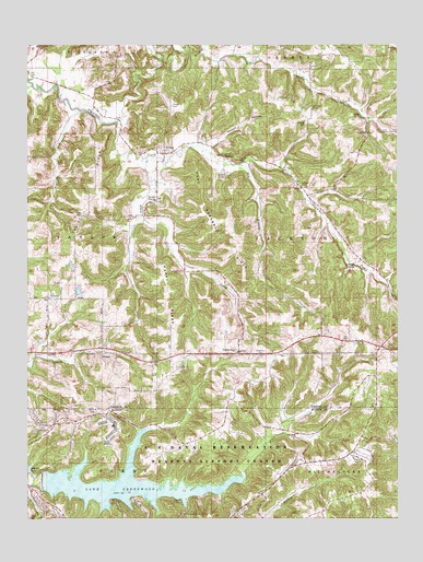
Koleen, IN USGS Topographic Map
Click on map above to begin viewing in our Map Viewer.

This topographic map contains these locations and features:
Feature Name Type Latitude Longitude GNIS ID View Map
Ashcraft ChapelChurchN38.9625°W86.7822°430305View Map
Black Ankle CreekStreamN38.9706°W86.8347°431116View Map
Clifty BranchStreamN38.9800°W86.8444°432656View Map
Clifty ChapelChurchN38.9770°W86.7611°432657View Map
Cooper CemeteryCemeteryN38.9656°W86.8083°432943View Map
DoansPopulated PlaceN38.9192°W86.8494°433586View Map
Dry BranchStreamN38.9689°W86.8022°433699View Map
Duke CemeteryCemeteryN38.9809°W86.7636°433760View Map
Flyblow BranchStreamN38.9853°W86.8628°434621View Map
Gingerich Lake DamDamN38.9334°W86.8583°447747View Map
Greenwood LakeReservoirN38.8841°W86.8423°435473View Map
Greenwood Lake DamDamN38.8848°W86.8703°448697View Map
Haney RidgeRidgeN38.9384°W86.8283°435673View Map
Happy HollowValleyN38.9734°W86.8139°435708View Map
Hard Scrabble RidgeRidgeN38.9462°W86.8044°435725View Map
Howell CemeteryCemeteryN38.9842°W86.8264°436552View Map
Kentucky Ridge ChurchChurchN38.9192°W86.8039°437258View Map
KoleenPopulated PlaceN38.9714°W86.8289°437432View Map
Little Clifty BranchStreamN38.9981°W86.8167°451154View Map
Oberlin LakeReservoirN38.8883°W86.8744°452472View Map
Osborne SpringSpringN38.9420°W86.7643°440719View Map
Pleasant Ridge Post Office (historical)Post OfficeN38.9173°W86.8256°453015View Map
Rankin SpringSpringN38.9588°W86.8321°441770View Map
Robison CemeteryCemeteryN38.9837°W86.7789°442184View Map
Rock SpringsSpringN38.9708°W86.8081°442213View Map
Stalcup BranchStreamN38.9973°W86.8317°444052View Map
Taylor RidgeRidgeN38.9600°W86.8519°444602View Map
Taylor Ridge CemeteryCemeteryN38.9553°W86.8564°444604View Map
Township of JacksonCivilN38.9489°W86.7571°453445View Map
Wagoner CemeteryCemeteryN38.9184°W86.7958°445356View Map

Note: Coordinates in the location and feature list above are referenced to NAD83 datum.


Copyright (C) 2008-2025 Ryan Niemi / Sunset Dynamics ... All Rights Reserved