TopoQuest Logo
Do you find TopoQuest useful?
Help keep TopoQuest running and adding new maps/features by donating!
Bitcoin:  19c7KJd3qBynnjoSw5npx9KScwjBe4ifkT
Litecoin:  LXs6TkuXGGXo1vDsWCkWVdjQX94eUKd6ui
Home View Maps Find Maps Find Places Resources & Links


Williams, Indiana Topographic Map

USGS Map Title: Williams, IN
USGS Map MRC: 38086G6
DRG (GeoTIFF) Download: o38086g6.tif


Neighboring USGS Topographic Map Quads:


  Koleen, IN  
38086H7
 

  Owensburg, IN  
38086H6
 

  Oolitic, IN  
38086H5
 

  Indian Springs, IN  
38086G7
 

  Williams, IN  
38086G6
 

  Bedford West, IN  
38086G5
 

  Shoals, IN  
38086F7
 

  Huron, IN  
38086F6
 

  Georgia, IN  
38086F5


Map MRC Location:

N39°
W87°
N39°
W86°
H8 H7 H6 H5 H4 H3 H2 H1
G8 G7 G6 G5 G4 G3 G2 G1
F8 F7 F6 F5 F4 F3 F2 F1
E8 E7 E6 E5 E4 E3 E2 E1
D8 D7 D6 D5 D4 D3 D2 D1
C8 C7 C6 C5 C4 C3 C2 C1
B8 B7 B6 B5 B4 B3 B2 B1
A8 A7 A6 A5 A4 A3 A2 A1
N38°
W87°
N38°
W86°

Williams, IN USGS 1:24K Topographic Map Preview:
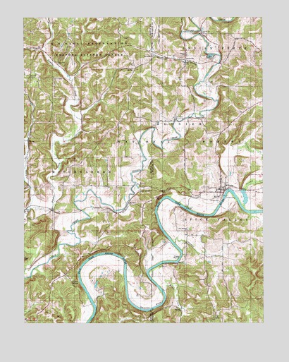
Williams, IN USGS Topographic Map
Click on map above to begin viewing in our Map Viewer.

This topographic map contains these locations and features:
Feature Name Type Latitude Longitude GNIS ID View Map
Chandler CemeteryCemeteryN38.8498°W86.7464°450764View Map
Chapman CreekStreamN38.7826°W86.6717°450767View Map
Chase RippleRapidsN38.7767°W86.6683°450768View Map
Crooked CreekStreamN38.7976°W86.6353°450816View Map
Fairview ChurchChurchN38.7526°W86.6500°451707View Map
Fort Williams ChurchChurchN38.7878°W86.6647°450924View Map
Haystack RocksSummitN38.8631°W86.6353°451775View Map
Henshaw BendBendN38.7578°W86.6836°451029View Map
Hooper CreekStreamN38.7631°W86.6772°451059View Map
Indian Creek ChurchChurchN38.8334°W86.6714°451084View Map
LaSalle SpringsSpringN38.7669°W86.7216°451127View Map
Little Sulphur CreekStreamN38.7973°W86.7475°451164View Map
Mount OlivePopulated PlaceN38.7987°W86.6942°451249View Map
Mount Olive ChurchChurchN38.8012°W86.6808°451250View Map
Mount Pleasant ChurchChurchN38.8595°W86.6817°451253View Map
Mountain Spring CemeteryCemeteryN38.8623°W86.7428°451260View Map
Mountain Spring Post Office (historical)Post OfficeN38.8620°W86.7411°453021View Map
Pleasant Hill CemeteryCemeteryN38.8689°W86.6575°451342View Map
Pleasant View ChurchChurchN38.7523°W86.6494°451349View Map
SilvervillePopulated PlaceN38.8575°W86.6653°451464View Map
Silverville BranchStreamN38.8489°W86.6572°451465View Map
Township of MitcheltreeCivilN38.8183°W86.7380°452421View Map
Uno-Paton CemeteryCemeteryN38.8517°W86.7314°452527View Map
Waggner CemeteryCemeteryN38.8600°W86.6653°451602View Map
Wagner CemeteryCemeteryN38.8556°W86.6922°451604View Map
WilliamsPopulated PlaceN38.8045°W86.6472°451629View Map
Williams BridgeBridgeN38.7967°W86.6653°451630View Map
Williams Census Designated PlaceCensusN38.8150°W86.6445°2583476View Map
Williams DamDamN38.8020°W86.6450°451762View Map
Williams Dam Public Fishing AreaParkN38.8017°W86.6456°451761View Map
Williams Volunteer Fire DepartmentBuildingN38.8063°W86.6476°2626418View Map

Note: Coordinates in the location and feature list above are referenced to NAD83 datum.


Copyright (C) 2008-2025 Ryan Niemi / Sunset Dynamics ... All Rights Reserved